Permian Reef Trail, Guadalupe Mountains National Park
Texas > Guadalupe Mountains National Park > Hiking > Permian Reef Trail
Permian Reef Trail
Steep route up the exposed limestone slopes on the northeast side of the lower end of McKittrick Canyon, to a lightly wooded plateau. The trail, now mostly level, continues into the adjacent Lincoln National Forest
Length: 3.2 miles to the edge of the ridge, 4.8 miles, to the national forest boundary
Elevation change: 2,000 feet
Difficulty: Moderate to strenuous
Type: One way
Usage: Low
Season: All year
Trailhead: End of a paved side road off US 62/180
Rating (1-5): ★★★★★
Elevation change: 2,000 feet
Difficulty: Moderate to strenuous
Type: One way
Usage: Low
Season: All year
Trailhead: End of a paved side road off US 62/180
Rating (1-5): ★★★★★

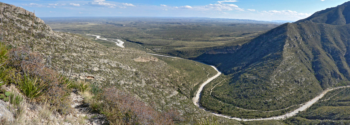
On the east side of Guadalupe Mountains National Park, McKittrick Canyon is a major ravine containing a year-round stream flowing through flourishing vegetation, and it provides a course for a wide, relatively easy trail, which follows the canyon for 3.4 miles, before winding very steeply up the valley sides. The walk to the base of the climb is one of the most popular in the park, but far fewer people hike the Permian Reef Trail, which starts from the same point.
In contrast to the cool, shady conditions alongside most of the stream, the reef trail ascends steadily up the exposed, barren limestone slopes on the northeast side of the hills at the mouth of the canyon, gaining 2,000 feet over 3.2 miles before levelling out abruptly on top of a sparsely wooded plateau (Camp Wilderness Ridge). Beyond, the route continues northwards close to the rim above the canyon, reaching the boundary of the Lincoln National Forest after 4.8 miles, and an alternative trailhead along a forest track after 5.8 miles. A primitive campground is available on the ridge, though the hike can easily be completed in one day, or half a day if just hiking to the edge of the plateau.
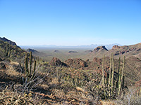
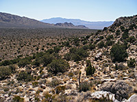
The trail is primarily promoted as a geological hike going to the variety of easily viewed rock formations on route, and a detailed guide is available describing 30 numbered features. Even more information is provided in a guidebook from the Texas Bureau of Economic Geology, and if studying the rocks and fossils in detail, two days are recommended. For non-geologists, attractions are the spectacular, if relatively little changing views on the ascent, a selection of interesting Chihuahuan Desert plants, and the abrupt transition to forested terrain once on the ridge.
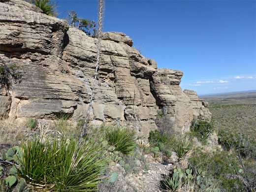
The slopes above the canyon face south so receive full sun all day, hence the hike is best avoided during hot periods in summer. The path was constructed in the early 1980s, and is named after the dominant geological formation, dating from the Permian period - the Capitan Reef, which forms all of the Guadalupe Mountains, the ridge enclosing the Carlsbad Caverns, and several other west Texas ranges.
Permian Reef Trail topographic map, Guadalupe Mountains location map.
14 views of the trail.
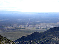
The McKittrick Canyon and Permian Reef trails start at the end of a 4.2 mile paved road forking off US 62/180. A fee of $5 is charged, per person. The road is open between 8 am and 6 pm, closed by a gate (at the south end) at other times, so it is not possible to watch sunsets from the trail, or get an early start on a hot summer's day. The visitor building at road's end is usually unstaffed; it has rest rooms, a few exhibits, trail maps, instructions about the procedure to follow if missing the gate closure, and a clock, useful since the park is close to the Mountain/Central time zone boundary, so some people are out by one hour.
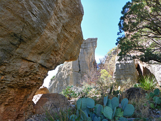
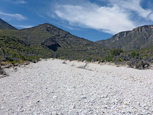
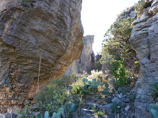
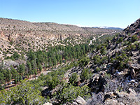
One path starts on the far side of the visitor building, immediately reaching a three-way junction; left is the 0.9 mile (loop) McKittrick Nature Trail, straight on the busy McKittrick Canyon Trail, and right is the lightly used Permian Reef Trail. The latter descends slightly and joins a gravel track - once the main route up the canyon, this crosses the wide, white, stony wash running down the ravine then bends left, soon rejoining the current trail, while Permian Reef route forks off to the north, along a minor tributary drainage and up a bushy hillside to the crest of a low ridge, and to the first of two junctions with a short geological spur trail. The main path veers west and is quite straight for 1,000 feet, across flat, gently inclined limestone bedrock, flanked by such plants as agave parryi ssp neomexicana, dasylirion leiophyllum and opuntia. The trail approaches a line of cliffs about 20 feet tall, and for a short distance passes behind some detached, thin-layered rocks, passing along shady corridors ('the Grottos') receiving subtle reflections and shadows, then moves back into the open, beneath more exposed, grey brown rock (wackestone, from the Lamar limestone member). The slopes nearby are home to specimens of two types of echinocereus cacti, coccineus and viridiflorus.
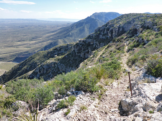
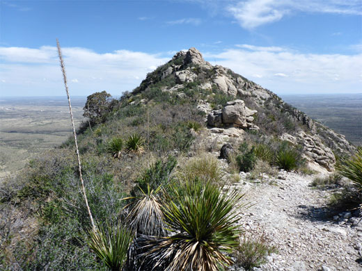
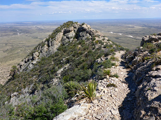
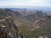
Two short switchbacks are followed by a long, quite steep section, curving slightly in and out of a few wide bowls, while traversing below a much bigger series of sheer cliffs - the main component of the Capitan Reef - several hundred feet above. The trail cuts back eastwards, becoming temporarily less steep, having by now climbed about half way to the ridge. It arrives at a saddle, just in front of a small hill, as the views become more extensive, now incorporating mountains and canyons to the north for the first time. Next is a similar, shorter traverse that leads to another, higher saddle and similar rocky knoll, before the final ascent, back westwards across a series of low, limestone steps and terraces of the Yates Formation, and up to the rim of Camp Wilderness Ridge.
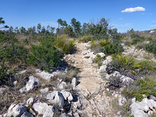
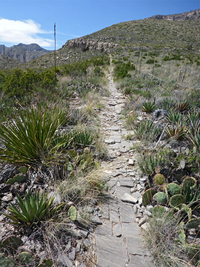
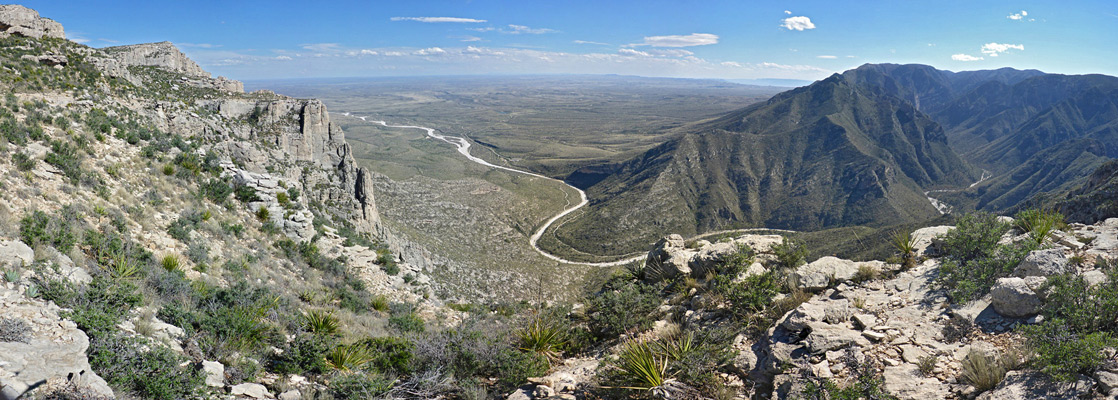
The land ahead is flat, lightly covered by trees, and a few summer wildflowers, most numerous being annual Townsend daisy. The path moves perpendicularly away from the rim, winds in and out of a little gully, curves round a treeless limestone hill and returns to the rim, giving the first good views of all of the lower section of McKittrick Canyon. The views extends southwest towards Hunter Peak, and south across many miles of the Chihuahuan Desert. The primitive campsite is a few hundred feet beyond, while the fence marking the national park boundary is reached after one mile, then after here, the path (now the Camp Wilderness Ridge Trail) reaches the Lincoln National Forest trailhead along FR 3008 after 2.1 miles.
In contrast to the cool, shady conditions alongside most of the stream, the reef trail ascends steadily up the exposed, barren limestone slopes on the northeast side of the hills at the mouth of the canyon, gaining 2,000 feet over 3.2 miles before levelling out abruptly on top of a sparsely wooded plateau (Camp Wilderness Ridge). Beyond, the route continues northwards close to the rim above the canyon, reaching the boundary of the Lincoln National Forest after 4.8 miles, and an alternative trailhead along a forest track after 5.8 miles. A primitive campground is available on the ridge, though the hike can easily be completed in one day, or half a day if just hiking to the edge of the plateau.
The trail is primarily promoted as a geological hike going to the variety of easily viewed rock formations on route, and a detailed guide is available describing 30 numbered features. Even more information is provided in a guidebook from the Texas Bureau of Economic Geology, and if studying the rocks and fossils in detail, two days are recommended. For non-geologists, attractions are the spectacular, if relatively little changing views on the ascent, a selection of interesting Chihuahuan Desert plants, and the abrupt transition to forested terrain once on the ridge.
The slopes above the canyon face south so receive full sun all day, hence the hike is best avoided during hot periods in summer. The path was constructed in the early 1980s, and is named after the dominant geological formation, dating from the Permian period - the Capitan Reef, which forms all of the Guadalupe Mountains, the ridge enclosing the Carlsbad Caverns, and several other west Texas ranges.
Maps
Permian Reef Trail topographic map, Guadalupe Mountains location map.
Photographs
14 views of the trail.
Trailhead
The McKittrick Canyon and Permian Reef trails start at the end of a 4.2 mile paved road forking off US 62/180. A fee of $5 is charged, per person. The road is open between 8 am and 6 pm, closed by a gate (at the south end) at other times, so it is not possible to watch sunsets from the trail, or get an early start on a hot summer's day. The visitor building at road's end is usually unstaffed; it has rest rooms, a few exhibits, trail maps, instructions about the procedure to follow if missing the gate closure, and a clock, useful since the park is close to the Mountain/Central time zone boundary, so some people are out by one hour.
Start of the Trail
One path starts on the far side of the visitor building, immediately reaching a three-way junction; left is the 0.9 mile (loop) McKittrick Nature Trail, straight on the busy McKittrick Canyon Trail, and right is the lightly used Permian Reef Trail. The latter descends slightly and joins a gravel track - once the main route up the canyon, this crosses the wide, white, stony wash running down the ravine then bends left, soon rejoining the current trail, while Permian Reef route forks off to the north, along a minor tributary drainage and up a bushy hillside to the crest of a low ridge, and to the first of two junctions with a short geological spur trail. The main path veers west and is quite straight for 1,000 feet, across flat, gently inclined limestone bedrock, flanked by such plants as agave parryi ssp neomexicana, dasylirion leiophyllum and opuntia. The trail approaches a line of cliffs about 20 feet tall, and for a short distance passes behind some detached, thin-layered rocks, passing along shady corridors ('the Grottos') receiving subtle reflections and shadows, then moves back into the open, beneath more exposed, grey brown rock (wackestone, from the Lamar limestone member). The slopes nearby are home to specimens of two types of echinocereus cacti, coccineus and viridiflorus.
Climb to the Plateau
Two short switchbacks are followed by a long, quite steep section, curving slightly in and out of a few wide bowls, while traversing below a much bigger series of sheer cliffs - the main component of the Capitan Reef - several hundred feet above. The trail cuts back eastwards, becoming temporarily less steep, having by now climbed about half way to the ridge. It arrives at a saddle, just in front of a small hill, as the views become more extensive, now incorporating mountains and canyons to the north for the first time. Next is a similar, shorter traverse that leads to another, higher saddle and similar rocky knoll, before the final ascent, back westwards across a series of low, limestone steps and terraces of the Yates Formation, and up to the rim of Camp Wilderness Ridge.
The Ridge
The land ahead is flat, lightly covered by trees, and a few summer wildflowers, most numerous being annual Townsend daisy. The path moves perpendicularly away from the rim, winds in and out of a little gully, curves round a treeless limestone hill and returns to the rim, giving the first good views of all of the lower section of McKittrick Canyon. The views extends southwest towards Hunter Peak, and south across many miles of the Chihuahuan Desert. The primitive campsite is a few hundred feet beyond, while the fence marking the national park boundary is reached after one mile, then after here, the path (now the Camp Wilderness Ridge Trail) reaches the Lincoln National Forest trailhead along FR 3008 after 2.1 miles.
Permian Reef Wildflowers
More plants along the trail
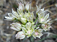 Largeflower onion |
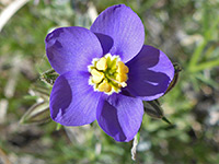 Bluebowls |
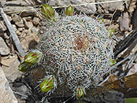 Nylon hedgehog cactus |
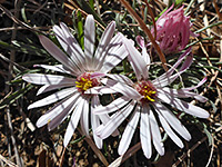 Annual Townsend daisy |
More plants along the trail
Permian Reef Trail - Similar Hikes
All Contents © Copyright The American Southwest | Comments and Questions | Contribute | Affiliate Marketing Disclosure | Site Map