Bull Pasture/Estes Canyon Trail, Organ Pipe Cactus National Monument
Arizona > Organ Pipe Cactus National Monument > Bull Pasture/Estes Canyon
Bull Pasture/Estes Canyon Trail
Interesting loop path that climbs into the Ajo Mountain foothills, up a ridge and down a valley, passing many types of cacti and giving excellent views
Length: 3.5 miles
Elevation change: 1,050 feet
Difficulty: Somewhat strenuous due to elevation change, but relatively short
Type: Loop
Usage: Light
Season: Any, though conditions are very hot in summer
Trailhead: Estes Canyon, half way along Ajo Mountain Drive
Rating (1-5): ★★★★★
Elevation change: 1,050 feet
Difficulty: Somewhat strenuous due to elevation change, but relatively short
Type: Loop
Usage: Light
Season: Any, though conditions are very hot in summer
Trailhead: Estes Canyon, half way along Ajo Mountain Drive
Rating (1-5): ★★★★★

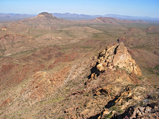
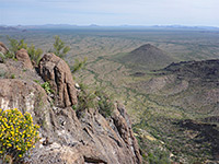
The 3.5 mile loop to Estes Canyon and Bull Pasture (an elevated plateau) is probably the most interesting of the small number of maintained paths in Organ Pipe Cactus National Monument - the route climbs high into the Ajo Mountains, passing numerous species of cacti and other desert plants, and a variety of landscapes. Views from the end point extend for over 20 miles across the flat Sonoyta Valley into Mexico, and for a similar distance west to the Puerto Blanco Mountains.
With an elevation gain of 1,050 feet, the path is somewhat strenuous, particularly in midsummer when the temperature may exceed 110°F, though it can be done in a couple of hours or so hence an early morning start on even the hottest day should see relatively pleasant conditions.
Organ Pipe Cactus map, topographic map of Bull Pasture and Estes Canyon.
11 views of the Bull Pasture and Estes Canyon Trail.
The path starts at the Estes Canyon picnic area, half way along the unpaved Ajo Mountain Drive, an 11 mile (ca. 45 minute) journey from AZ 85. The loop is best hiked in the counter-clockwise direction since the elevation gain is more gradual, and the views are better at the start. This path ascends steadily, first to a ridge overlooking Estes Canyon and then to the final viewpoint at Bull Pasture. The return is via another path that descends into the canyon and follows a dry wash back to the trailhead.
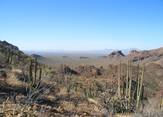
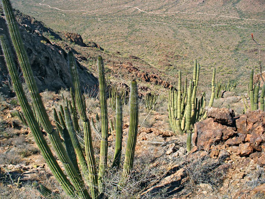
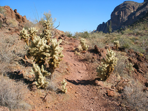
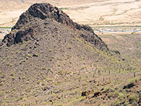
The first section of the route climbs the north side of a small ravine, winding past a few eroded rocky outcrops, and quite soon has fine views southwards across Sonoyta Valley to the Mexican border. The Ajo Range rises high above to the east, providing partial shade for several hours in the morning. The trail bends back to the north, still not ascending too steeply, up to a saddle above the upper end of Estes Canyon, then soon after arrives at the junction with the path down. Ahead are tall cliffs at the head of the valley, dotted with a few saguaro and organ pipes, clinging to crevices in the rhyolite rock face.
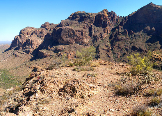
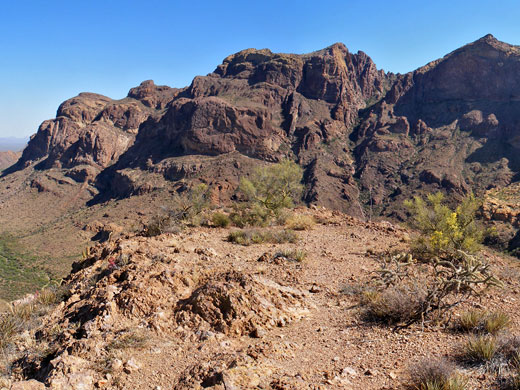
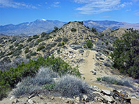
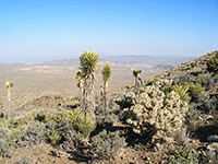
The final half mile to Bull Pasture zig-zags up a slope to a higher ridge and ends with a straighter section up to a flat area with a trail register and sign. Although high above the valley, the plateau is still over 1,400 feet below the summit of the mountains (4,808 foot Mount Ajo), a point which can be reached by a rather more difficult hike along a fainter continuation trail. Another short path leads south from the trail register to the top of a small summit that gives better views of the surroundings; from here about half of the Ajo Mountain Drive can be seen, as well as many distant hills, extending well south into Mexico.
Back at the junction above Estes Canyon, the return part of the loop (1.5 miles) descends steeply to the valley floor through many switchbacks then runs alongside the dry wash, mostly on the north side though crossing back to the south near the end. The land around the streambed is dusty, quite overgrown by cacti and bushes, and is sheltered from the wind owing to high hills at either side, so the path feels especially hot in summer. Views are restricted but the trail passes a good range of plants, both desert and riparian, and has a better chance of encountering wildlife than the alternative path.
With an elevation gain of 1,050 feet, the path is somewhat strenuous, particularly in midsummer when the temperature may exceed 110°F, though it can be done in a couple of hours or so hence an early morning start on even the hottest day should see relatively pleasant conditions.
Maps
Organ Pipe Cactus map, topographic map of Bull Pasture and Estes Canyon.
Photographs
11 views of the Bull Pasture and Estes Canyon Trail.
Estes Canyon Trailhead
The path starts at the Estes Canyon picnic area, half way along the unpaved Ajo Mountain Drive, an 11 mile (ca. 45 minute) journey from AZ 85. The loop is best hiked in the counter-clockwise direction since the elevation gain is more gradual, and the views are better at the start. This path ascends steadily, first to a ridge overlooking Estes Canyon and then to the final viewpoint at Bull Pasture. The return is via another path that descends into the canyon and follows a dry wash back to the trailhead.
Start of the Trail
The first section of the route climbs the north side of a small ravine, winding past a few eroded rocky outcrops, and quite soon has fine views southwards across Sonoyta Valley to the Mexican border. The Ajo Range rises high above to the east, providing partial shade for several hours in the morning. The trail bends back to the north, still not ascending too steeply, up to a saddle above the upper end of Estes Canyon, then soon after arrives at the junction with the path down. Ahead are tall cliffs at the head of the valley, dotted with a few saguaro and organ pipes, clinging to crevices in the rhyolite rock face.
Bull Pasture
The final half mile to Bull Pasture zig-zags up a slope to a higher ridge and ends with a straighter section up to a flat area with a trail register and sign. Although high above the valley, the plateau is still over 1,400 feet below the summit of the mountains (4,808 foot Mount Ajo), a point which can be reached by a rather more difficult hike along a fainter continuation trail. Another short path leads south from the trail register to the top of a small summit that gives better views of the surroundings; from here about half of the Ajo Mountain Drive can be seen, as well as many distant hills, extending well south into Mexico.
Estes Canyon
Back at the junction above Estes Canyon, the return part of the loop (1.5 miles) descends steeply to the valley floor through many switchbacks then runs alongside the dry wash, mostly on the north side though crossing back to the south near the end. The land around the streambed is dusty, quite overgrown by cacti and bushes, and is sheltered from the wind owing to high hills at either side, so the path feels especially hot in summer. Views are restricted but the trail passes a good range of plants, both desert and riparian, and has a better chance of encountering wildlife than the alternative path.
Bull Pasture and Estes Canyon - Similar Hikes
All Contents © Copyright The American Southwest | Comments and Questions | Contribute | Affiliate Marketing Disclosure | Site Map