Pinkley Peak, Organ Pipe Cactus National Monument
Arizona > Organ Pipe Cactus National Monument > Pinkley Peak
Pinkley Peak
Highest peak in the Puerto Blanco Mountains, reachable by an off-trail hike - along a shallow drainage to a rocky bowl, then up steepening slopes to the jagged summit. Many cacti and spring wildflowers; fantastic views from the summit
Length: 1.3 miles
Elevation change: 1,220 feet
Difficulty: Moderate
Type: One way, off trail
Usage: Low
Season: Fall, winter, spring; very hot in summer
Trailhead: 5.2 miles along Puerto Blanco Drive
Rating (1-5): ★★★★★
Elevation change: 1,220 feet
Difficulty: Moderate
Type: One way, off trail
Usage: Low
Season: Fall, winter, spring; very hot in summer
Trailhead: 5.2 miles along Puerto Blanco Drive
Rating (1-5): ★★★★★

There are relatively few trails in Organ Pipe Cactus National Monument, but cross-country hiking is easy enough in many places, and is promoted by the NPS - the desert vegetation is well spaced, navigation is helped by the lack of trees and the presence of several prominent mountains to act as landmarks, and the land is fairly level. Such hiking is not without risk, however, because of the dangers of poisonous wildlife (snakes, scorpions and spiders), the spiky cacti, activities associated with illegal immigration and smuggling, plus the intense heat that prevails for much of the year.
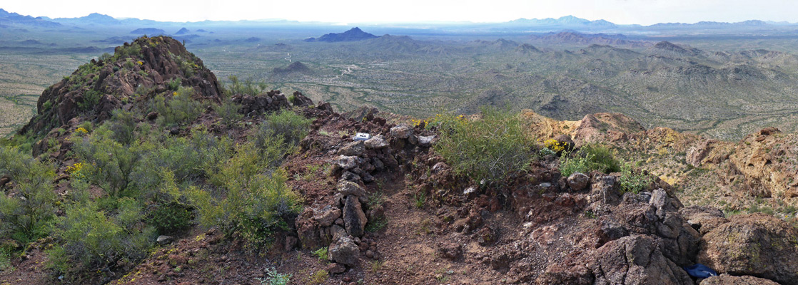
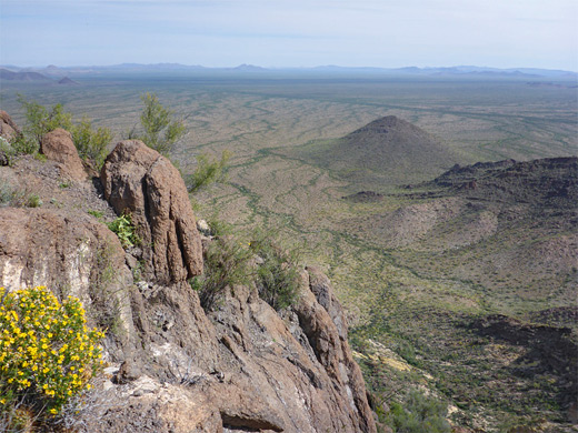
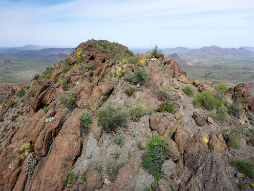
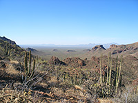
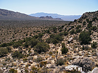
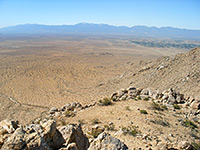
One such off-trail route is the 1.3 mile hike to the summit of Pinkley Peak, which is the highest point in the Puerto Blanco Mountains, a conspicuous range in the south central portion of the park, rather smaller than the Ajo Range to the east but equally dramatic. As there are no higher places nearby, the summit affords fantastic, unobscured, panoramic views over the whole national monument, and south into Mexico.
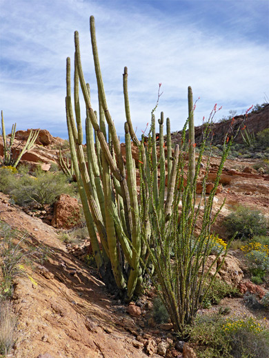
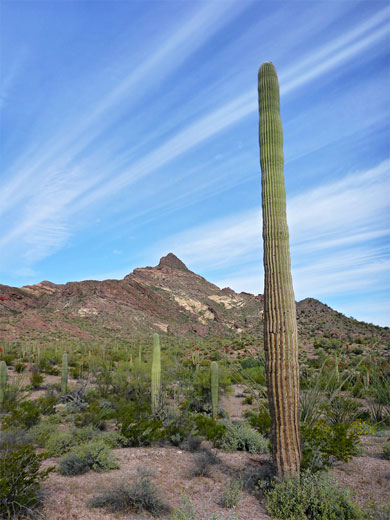
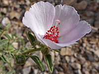
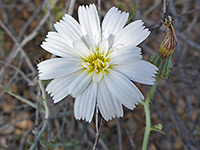
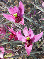
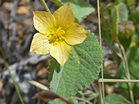
Starting from a picnic/parking area along Puerto Blanco Drive, the suggested route is half along a wide valley, containing plenty of saguaro and organ pipe cacti, then up the increasingly steep slopes below the east face of the peak. Most is straightforward, but some parts of the hillside are covered by loose gravel, while other sections have bands of vertical cliffs, where some effort is needed to identify a suitable route. Apart from the grand views, one other highlight is the varied vegetation - many species of wildflowers mingle with the cacti and bushes, contrasting with the jagged, richly colored volcanic rocks, which are mainly red but crossed by bands of pale yellow.
Organ Pipe Cactus National Monument map.
27 views of Pinkley Peak.
Parking for the hike is at the end of the wide, 2WD section of Puerto Blanco Drive, at a picnic area with restrooms and shaded seating - beyond, the road is narrower, rougher and much less traveled, partly because some sections require a 4WD vehicle. This location is 5.2 miles from Highway 85.
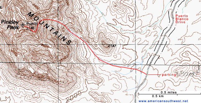
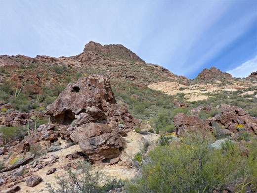
This stretch of Puerto Blanco Drive passes close to the eastern edge of the northern half of the Puerto Blanco Mountains, which is separated by a wide valley from the lower but slightly larger southern half, where several trails lead to such sites as Baker Mine and Senita Basin. This northerly component of the mountains is narrow but relatively long, extending 7 miles westwards, with the highest point - Pinkley Peak - at the east end, and so clearly visible from the parking area, its sides covered mostly by red brown, volcanic rocks. From a distance the uppermost part, just below the summit, looks very steep-sided, while the lower reaches slope much more gently.
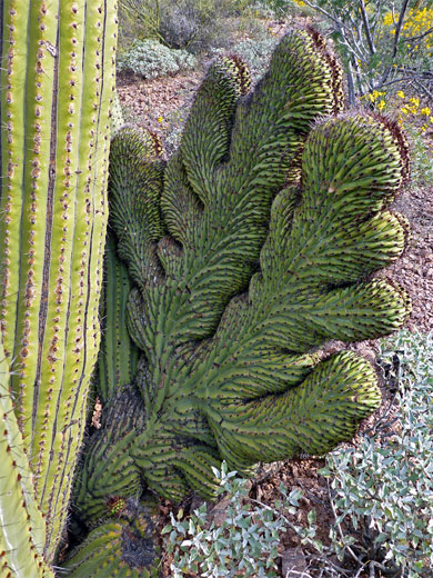
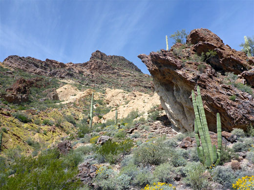
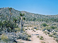
The route to the peak starts due east, past the picnic ramadas, over two shallow washes and alongside a slightly larger drainage, which is quite bushy and overgrown along the streambed but bordered on both sides by flat, gravelly, sparsely vegetated land that provides easy walking conditions. There are still plenty of plants around, ranging from tiny yellow suncups to big saguaro and ocotillo. Organ pipe cacti do not grow on the flats but they start to appear not far ahead, as the land gradually rises. The drainage originates from a rocky bowl a little way beyond a subsidiary peak on the north side; it splits near the upper end and the easiest route seems to be up the sloping ridge between the two branches. Just before the junction, on the north side of the streambed, is a large organ pipe cactus with two cristate growths at the base. The upper sections of the drainage are steep, overgrown and contain boulders and dryfalls, but the intervening ridge is largely free of obstructions, and gives way to a broader slope, steadily steepening; again without any great problems apart from the loose gravel in some places, which is more of an issue when descending.
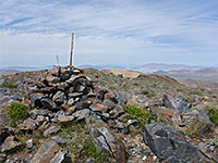
The hillside becomes briefly more level at a bench about 400 feet below the peak, where the land to the north becomes properly visible for the first time. The last section of the route is up a slanted slope to the base of the final outcrop, then along a rocky ridge to the summit, which is narrow and about 200 feet long, marked with two USGS points. Perhaps surprisingly for this remote, trailless location, the summit and parts of the upper slopes are covered with much litter, left by people moving northwards across the desert from Mexico; the peak is an extremely good lookout place, and several alcoves provide cool, sheltered places to rest or hide during the daylight hours. Clothes, shoes, bags, food wrappers, black water containers and various other items can be found in many places, most densely in and around a small cave on the summit.
One such off-trail route is the 1.3 mile hike to the summit of Pinkley Peak, which is the highest point in the Puerto Blanco Mountains, a conspicuous range in the south central portion of the park, rather smaller than the Ajo Range to the east but equally dramatic. As there are no higher places nearby, the summit affords fantastic, unobscured, panoramic views over the whole national monument, and south into Mexico.
Starting from a picnic/parking area along Puerto Blanco Drive, the suggested route is half along a wide valley, containing plenty of saguaro and organ pipe cacti, then up the increasingly steep slopes below the east face of the peak. Most is straightforward, but some parts of the hillside are covered by loose gravel, while other sections have bands of vertical cliffs, where some effort is needed to identify a suitable route. Apart from the grand views, one other highlight is the varied vegetation - many species of wildflowers mingle with the cacti and bushes, contrasting with the jagged, richly colored volcanic rocks, which are mainly red but crossed by bands of pale yellow.
Location
Organ Pipe Cactus National Monument map.
Photographs
27 views of Pinkley Peak.
Pinkley Peak Trailhead
Parking for the hike is at the end of the wide, 2WD section of Puerto Blanco Drive, at a picnic area with restrooms and shaded seating - beyond, the road is narrower, rougher and much less traveled, partly because some sections require a 4WD vehicle. This location is 5.2 miles from Highway 85.
The Mountains
This stretch of Puerto Blanco Drive passes close to the eastern edge of the northern half of the Puerto Blanco Mountains, which is separated by a wide valley from the lower but slightly larger southern half, where several trails lead to such sites as Baker Mine and Senita Basin. This northerly component of the mountains is narrow but relatively long, extending 7 miles westwards, with the highest point - Pinkley Peak - at the east end, and so clearly visible from the parking area, its sides covered mostly by red brown, volcanic rocks. From a distance the uppermost part, just below the summit, looks very steep-sided, while the lower reaches slope much more gently.

The Route
The route to the peak starts due east, past the picnic ramadas, over two shallow washes and alongside a slightly larger drainage, which is quite bushy and overgrown along the streambed but bordered on both sides by flat, gravelly, sparsely vegetated land that provides easy walking conditions. There are still plenty of plants around, ranging from tiny yellow suncups to big saguaro and ocotillo. Organ pipe cacti do not grow on the flats but they start to appear not far ahead, as the land gradually rises. The drainage originates from a rocky bowl a little way beyond a subsidiary peak on the north side; it splits near the upper end and the easiest route seems to be up the sloping ridge between the two branches. Just before the junction, on the north side of the streambed, is a large organ pipe cactus with two cristate growths at the base. The upper sections of the drainage are steep, overgrown and contain boulders and dryfalls, but the intervening ridge is largely free of obstructions, and gives way to a broader slope, steadily steepening; again without any great problems apart from the loose gravel in some places, which is more of an issue when descending.
The Pinkley Peak Summit
The hillside becomes briefly more level at a bench about 400 feet below the peak, where the land to the north becomes properly visible for the first time. The last section of the route is up a slanted slope to the base of the final outcrop, then along a rocky ridge to the summit, which is narrow and about 200 feet long, marked with two USGS points. Perhaps surprisingly for this remote, trailless location, the summit and parts of the upper slopes are covered with much litter, left by people moving northwards across the desert from Mexico; the peak is an extremely good lookout place, and several alcoves provide cool, sheltered places to rest or hide during the daylight hours. Clothes, shoes, bags, food wrappers, black water containers and various other items can be found in many places, most densely in and around a small cave on the summit.
Topo Map of the Route
Pinkley Peak - Similar Hikes
All Contents © Copyright The American Southwest | Comments and Questions | Contribute | Affiliate Marketing Disclosure | Site Map