Baker Mine Trail, Organ Pipe Cactus National Monument
Arizona > Organ Pipe Cactus National Monument > Baker Mine Trail
Baker Mine Trail
Seldom hiked route along an old vehicle track, across fairly level terrain of small hills and stony dry washes, all densely covered with cacti and other Sonoran Desert plants, to the site of an abandoned gold mine
Length: 2.6 miles; trail continues 1.4 miles to another mine (Milton)
Elevation change: 100 feet
Difficulty: Easy, at cooler times of the year
Type: One way, or part of a 10 mile loop
Usage: Low
Season: Fall to spring; hot in summer
Trailhead: 4 miles along Puerto Blanco Drive
Rating (1-5): ★★★★★
Elevation change: 100 feet
Difficulty: Easy, at cooler times of the year
Type: One way, or part of a 10 mile loop
Usage: Low
Season: Fall to spring; hot in summer
Trailhead: 4 miles along Puerto Blanco Drive
Rating (1-5): ★★★★★

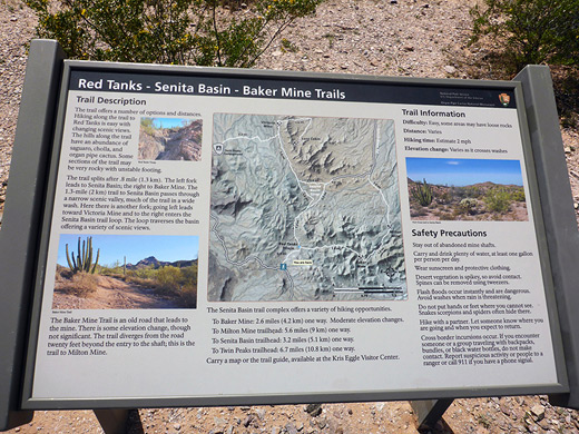
Most of the limited number of trails in Organ Pipe Cactus National Monument cross the Puerto Blanco Mountains, on the west side of Hwy 85; destinations include Victoria Mine, Senita Basin, Red Tanks Tinaja, Milton Mine and Baker Mine, which like many of the mining sites scattered over this part of far south Arizona produced small amounts of gold and silver in the early twentieth century.
The trail to Baker Mine is 2.6 miles long and fairly level, with just a few gentle climbs and descents, across undulating land of dry washes, desert flats and low ridges; by a short distance this is the furthest from a road of at least seven mines in this part of the monument, most of which are accessed from Puerto Blanco Drive. Relics at Baker Mine are somewhat limited, to a shaft, an adit and several small tailings piles, but the views on the hike are varied, and plant life is abundant, especially the organ pipe cactus. Past the mine, the path continues to other destinations (Milton Mine, Senita Basin, Red Tanks Tinaja) to make a ten mile loop, though these places can also be visited on shorter, one-way hikes.
Organ Pipe Cactus National Monument map, Baker Mine topographic map.
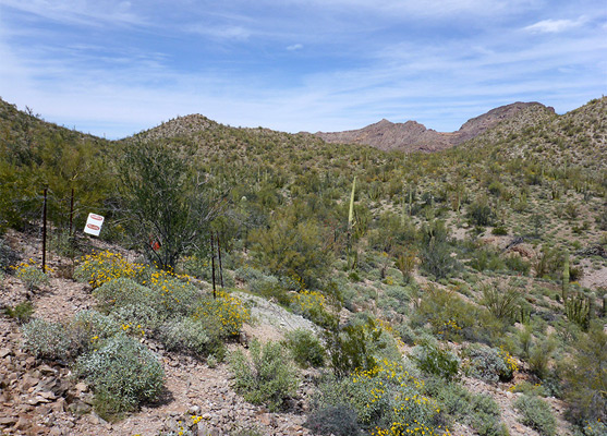
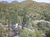
The trailhead is four miles along the northern section of Puerto Blanco Drive, one mile before the start of the rough, one-way section, which was reopened in 2014 after being closed for over ten years. Vehicles are parked at a small pull-out just north of the intersection with the disused mining track that leads to the mine, which forms most of the route for the trail. A map and informative notice describe the various hiking destinations, the closest and hence most visited being Red Tanks Tinaja.
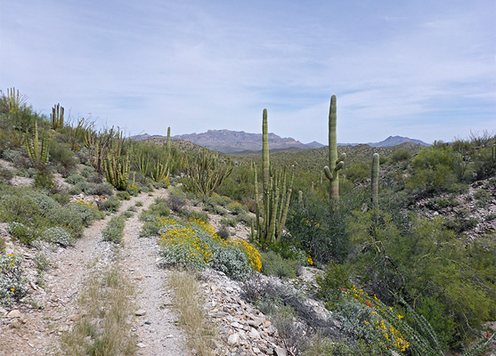
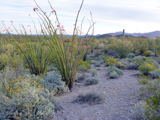
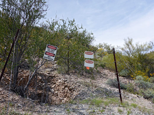
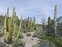
The start of the path is flat, across whitish earth which accentuates the summer heat. The surrounding land is covered with healthy specimens of the two largest cacti species, saguaro and organ pipes, while tiny, contrasting wildflowers appear in spring, most numerous being yellow suncups. The path soon joins the disused track, marked by another sign advising of the dangers relating to smuggling, then the track crosses a small wash and follows a similar sized tributary southwards, later rising slightly over a low ridge and dropping back down into a larger, bushier drainage. A junction is reached on the far side, where the left fork leads to Red Tanks Tinaja and Senita Basin, the former a nearby section of the streamway which harbors several permanent pools enclosed by reddish rocks, while right is the lesser-used path to Baker Mine.
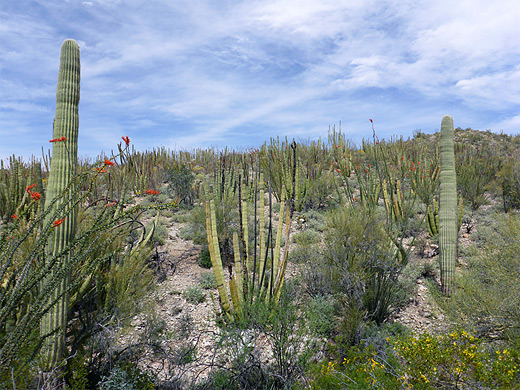
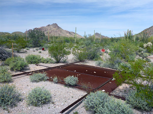
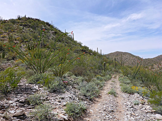
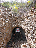
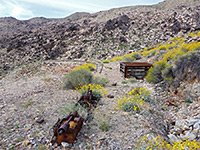
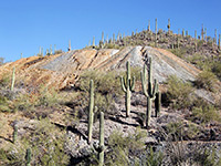
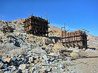
From the junction, the track to the mine runs for a short distance close to the rim of the shallow ravine enclosing the streamway, before crossing back to the north side and climbing gradually, aiming for a saddle between small, rounded hills. The land on the far side is similar - sloping gently down, crossed by small, dry stony washes. Cacti grow especially densely hereabouts, particularly on a hill to the north, where organ pipes mix with similarly shaped ocotillo - both have narrow stems, branch from the ground, and reach about the same height. The path traverses the hillside on the north side of a deepening valley, up to a second saddle, then gradually moves down across more open slopes to the floor of the next valley, over a streambed a couple of times to Baker Mine, its position marked with a sign, which also gives the mileage to the next destination, Milton Mine (1.4 miles). The most noticeable remnant at Baker Mine is a fenced-off shaft with multilingual warning notices, while just to the south is an adit, enclosed with vertical iron bars and barbed wire, leaving enough space for its resident bat colony to enter and exit. Some test excavations and tailings piles are the only other relics; there are no pieces of iron equipment or remains of buildings. Colorful rocks are scattered about, including greenish blue chalcedony.
The trail to Baker Mine is 2.6 miles long and fairly level, with just a few gentle climbs and descents, across undulating land of dry washes, desert flats and low ridges; by a short distance this is the furthest from a road of at least seven mines in this part of the monument, most of which are accessed from Puerto Blanco Drive. Relics at Baker Mine are somewhat limited, to a shaft, an adit and several small tailings piles, but the views on the hike are varied, and plant life is abundant, especially the organ pipe cactus. Past the mine, the path continues to other destinations (Milton Mine, Senita Basin, Red Tanks Tinaja) to make a ten mile loop, though these places can also be visited on shorter, one-way hikes.
Maps
Organ Pipe Cactus National Monument map, Baker Mine topographic map.
Baker Mine Trailhead
The trailhead is four miles along the northern section of Puerto Blanco Drive, one mile before the start of the rough, one-way section, which was reopened in 2014 after being closed for over ten years. Vehicles are parked at a small pull-out just north of the intersection with the disused mining track that leads to the mine, which forms most of the route for the trail. A map and informative notice describe the various hiking destinations, the closest and hence most visited being Red Tanks Tinaja.
Trail to Red Tanks Tinaja Junction
The start of the path is flat, across whitish earth which accentuates the summer heat. The surrounding land is covered with healthy specimens of the two largest cacti species, saguaro and organ pipes, while tiny, contrasting wildflowers appear in spring, most numerous being yellow suncups. The path soon joins the disused track, marked by another sign advising of the dangers relating to smuggling, then the track crosses a small wash and follows a similar sized tributary southwards, later rising slightly over a low ridge and dropping back down into a larger, bushier drainage. A junction is reached on the far side, where the left fork leads to Red Tanks Tinaja and Senita Basin, the former a nearby section of the streamway which harbors several permanent pools enclosed by reddish rocks, while right is the lesser-used path to Baker Mine.
Trail to Baker Mine
From the junction, the track to the mine runs for a short distance close to the rim of the shallow ravine enclosing the streamway, before crossing back to the north side and climbing gradually, aiming for a saddle between small, rounded hills. The land on the far side is similar - sloping gently down, crossed by small, dry stony washes. Cacti grow especially densely hereabouts, particularly on a hill to the north, where organ pipes mix with similarly shaped ocotillo - both have narrow stems, branch from the ground, and reach about the same height. The path traverses the hillside on the north side of a deepening valley, up to a second saddle, then gradually moves down across more open slopes to the floor of the next valley, over a streambed a couple of times to Baker Mine, its position marked with a sign, which also gives the mileage to the next destination, Milton Mine (1.4 miles). The most noticeable remnant at Baker Mine is a fenced-off shaft with multilingual warning notices, while just to the south is an adit, enclosed with vertical iron bars and barbed wire, leaving enough space for its resident bat colony to enter and exit. Some test excavations and tailings piles are the only other relics; there are no pieces of iron equipment or remains of buildings. Colorful rocks are scattered about, including greenish blue chalcedony.
Baker Mine Wildflower
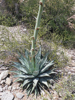 Desert agave |
Baker Mine Trail - Similar Hikes

All Contents © Copyright The American Southwest | Comments and Questions | Contribute | Affiliate Marketing Disclosure | Site Map