Gould Mine Trail, Saguaro National Park
Arizona > Saguaro National Park > West > Hiking > Gould Mine Trail
Gould Mine Trail
Short path up a ravine past many flourishing cacti to some colorful old mine workings; usually combined with parts of the Sendero Esperanza and King Canyon trails to make a loop hike
Length: 1.1 miles; 2.5 miles for the loop
Elevation change: 300 feet
Difficulty: Easy
Type: One way, or loop
Usage: Medium
Season: Best from fall to spring
Trailhead: Along Kinney Road, near Arizona-Sonora Desert Museum
Rating (1-5): ★★★★★
Elevation change: 300 feet
Difficulty: Easy
Type: One way, or loop
Usage: Medium
Season: Best from fall to spring
Trailhead: Along Kinney Road, near Arizona-Sonora Desert Museum
Rating (1-5): ★★★★★

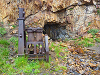
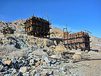
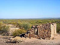
The smaller west section of Saguaro National Park has a good selection of footpaths, longest being the Hugh Norris Trail to Wasson Peak, but most are shorter and less steep, crossing flat land or mountain foothills, giving both long distance vistas and close-up views of the varied Sonoran Desert plantlife. One route with an added attraction is the 1.1 mile Gould Mine Trail, which climbs gently up a ravine to the site of a long-disused copper mine, where relics include colorful tailings piles, two shafts and a stone cabin, plus scattered pieces of wood and ironwork.
The path to the mine is often combined with part of the King Canyon and Sendero Esperanza trails to create a 2.5 mile loop; an easy hike that can be completed in not much more than an hour. Also en route is the Mam-A-Gah picnic area, scenically situated on a small hill, looking west down King Canyon to Avra Valley, and east across the upper reaches of the Tucson Mountains.
The unsignposted trailhead for Gould Mine and King Canyon lies just outside the national park boundary along Kinney Road - within the adjacent Tucson Mountain Park, and nearly opposite the entrance to the popular Arizona-Sonora Desert Museum. Parking is on a gravel hill bordering the east side of the highway, and for long vehicles is easiest entered when approaching from the south, as the northern turning is rather tight.
The suggested first part of the Gould Mine loop is along the King Canyon Trail, a wide route, once a vehicle track, which follows the north side of a sizeable dry wash, staying some way above the streambed. The surface underfoot is stony or rocky but walking is straightforward, across bushy slopes up to a flat area followed by a short descent to the wash, where the King Canyon Trail continues upstream, while the Sendero Esperanza Trail joins from the north, climbing the far side of the ravine to the Mam-A-Gah picnic area. This has shaded tables, benches and bbq grills, all sturdily built from the local stone. A less used path branches off (to another old mine), while the main route crosses a smaller wash, climbs to a saddle and drops down into the neighboring valley, where the reddish tailings piles from Gould Mine come into view, a little way up the hillside to the north.
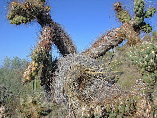
The mine site comprises one main shaft, fenced-off and covered by an iron grille, plus a second shaft downhill and a small stone cabin beside the path. Plant life in the vicinity, and along the trails, includes four types of cholla cactus (teddy bear, jumping, buckhorn, pencil), the pink flowered hedgehog cactus (echinocereus fasciculatus), ocotillo, ferocactus, mammillaria and of course the ever-present saguaro. The path back to the trailhead - the Gould Mine Trail - runs along the dry streambed of the ravine below the mine, through groups of mesquite and ironwood trees, rounds the edge of a ridge, crosses Kings Canyon and meets the entry path. Most parts of the loop allow distant views southwest, across Avra Valley to the far-away mountains of the Tohono O'Odham Reservation. Besides the maintained paths, disused mine tracks branch off in several places.
The path to the mine is often combined with part of the King Canyon and Sendero Esperanza trails to create a 2.5 mile loop; an easy hike that can be completed in not much more than an hour. Also en route is the Mam-A-Gah picnic area, scenically situated on a small hill, looking west down King Canyon to Avra Valley, and east across the upper reaches of the Tucson Mountains.
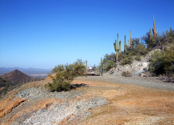
Gould Mine Trailhead
The unsignposted trailhead for Gould Mine and King Canyon lies just outside the national park boundary along Kinney Road - within the adjacent Tucson Mountain Park, and nearly opposite the entrance to the popular Arizona-Sonora Desert Museum. Parking is on a gravel hill bordering the east side of the highway, and for long vehicles is easiest entered when approaching from the south, as the northern turning is rather tight.
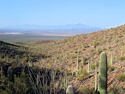
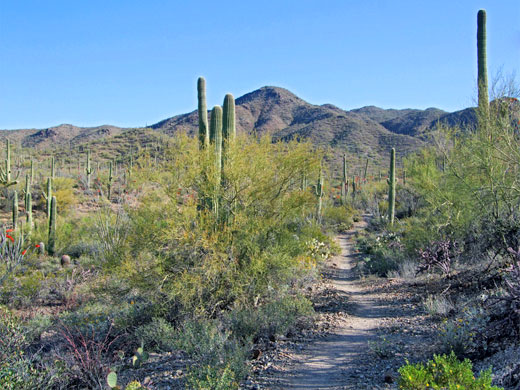
Start of the Trail
The suggested first part of the Gould Mine loop is along the King Canyon Trail, a wide route, once a vehicle track, which follows the north side of a sizeable dry wash, staying some way above the streambed. The surface underfoot is stony or rocky but walking is straightforward, across bushy slopes up to a flat area followed by a short descent to the wash, where the King Canyon Trail continues upstream, while the Sendero Esperanza Trail joins from the north, climbing the far side of the ravine to the Mam-A-Gah picnic area. This has shaded tables, benches and bbq grills, all sturdily built from the local stone. A less used path branches off (to another old mine), while the main route crosses a smaller wash, climbs to a saddle and drops down into the neighboring valley, where the reddish tailings piles from Gould Mine come into view, a little way up the hillside to the north.
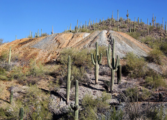
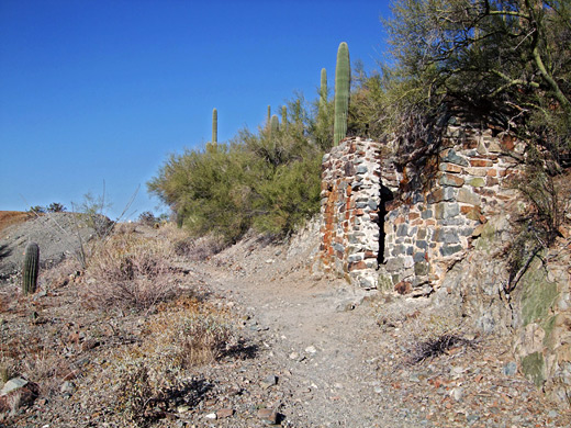
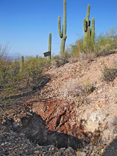
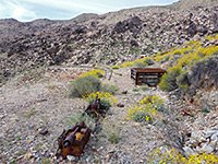
Gould Mine
The mine site comprises one main shaft, fenced-off and covered by an iron grille, plus a second shaft downhill and a small stone cabin beside the path. Plant life in the vicinity, and along the trails, includes four types of cholla cactus (teddy bear, jumping, buckhorn, pencil), the pink flowered hedgehog cactus (echinocereus fasciculatus), ocotillo, ferocactus, mammillaria and of course the ever-present saguaro. The path back to the trailhead - the Gould Mine Trail - runs along the dry streambed of the ravine below the mine, through groups of mesquite and ironwood trees, rounds the edge of a ridge, crosses Kings Canyon and meets the entry path. Most parts of the loop allow distant views southwest, across Avra Valley to the far-away mountains of the Tohono O'Odham Reservation. Besides the maintained paths, disused mine tracks branch off in several places.
Gould Mine Trail - Similar Hikes

All Contents © Copyright The American Southwest | Comments and Questions | Contribute | Affiliate Marketing Disclosure | Site Map