Lost Horse Mine Trail, Joshua Tree National Park
California > Joshua Tree National Park > Hiking > Lost Horse Mine
Lost Horse Mine Trail
Well preserved ten stamp mill and other mining relics, reached by an enjoyable trail that also has far reaching views over the surrounding desert and mountains
Length: 2 miles
Elevation change: 480 feet
Difficulty: Easy to moderate
Type: One way, or part of an optional 6 mile loop that climbs a little further into the hills
Usage: Medium
Season: All year
Trailhead: End of a short track forking off the road to Keys View
Rating (1-5): ★★★★★
Elevation change: 480 feet
Difficulty: Easy to moderate
Type: One way, or part of an optional 6 mile loop that climbs a little further into the hills
Usage: Medium
Season: All year
Trailhead: End of a short track forking off the road to Keys View
Rating (1-5): ★★★★★

Assorted mining relics including one of the best preserved ten stamp mills in California are the main points of interest along the Lost Horse Mine Trail, an easy route that like most others in Joshua Tree National Park also passes an assortment of colorful desert plants and has long distance views over desert plains and distant mountains. The hike can be done either as an out-and-back trip over the old vehicle track leading to the mine (total 4 miles), or as a 6 mile loop, since after the mine a narrower trail climbs higher into the hills and returns via an alternative route along a bushy ravine.
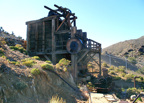
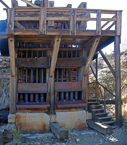
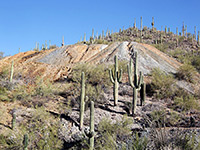
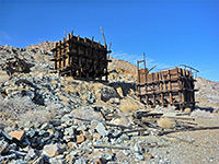
The ten stamp mill is enclosed by a metal fence for protection, spoiling its appearance somewhat but still the site is evocative, and not at all busy - the walk might be quite gentle but 4 miles is far enough to discourage the casual visitor. Lost Horse Mine opened in 1894, producing good amounts of gold and silver for just over ten years, then lesser quantities up until 1931 when the site was abandoned.
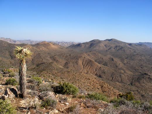
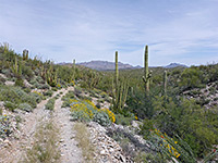
The Lost Horse Mine trailhead is reached by an unpaved, mile long side track forking off the road through Lost Horse Valley to Keys View. The track crosses flat, sandy land sprinkled with Joshua trees, ending at a small parking area from where the path begins, heading due east over undulating land bearing scattered cacti, yucca, nolina and wildflowers, though no more Joshua trees. The upwards gradient is never very steep, and the trail gains a moderate 480 feet in the 2 miles to the mine. Views open up after a while, as distant lands to the north and east become visible.
The mine can be seen from about half a mile away, perched on sloping ground just below the top of a hill, near the head of a rocky ravine. The trail climbs up the ravine, past a junction with a short spur to the mine, then continues southeastwards to the top of a ridge, for even better views of the surroundings. From here the route descends a little, turns back west and rises to cross a saddle quite close to the summit of Lost Horse Mountain (5,313 feet). There is another old mine site near the saddle, and a third reached by a side trail a little further on, as the main path drops down into a Joshua tree-studded valley on the west side of the mountain, a drainage that is followed for 2 miles back to the trailhead.
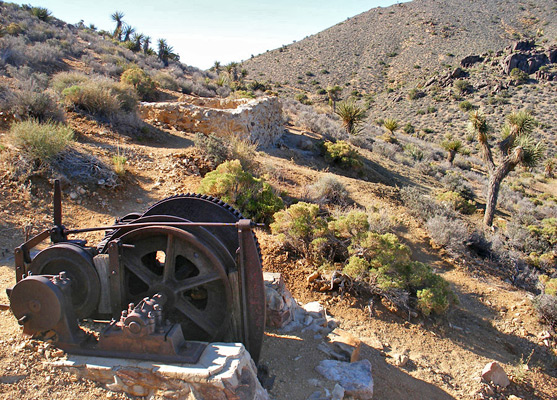
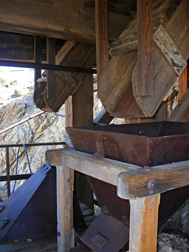
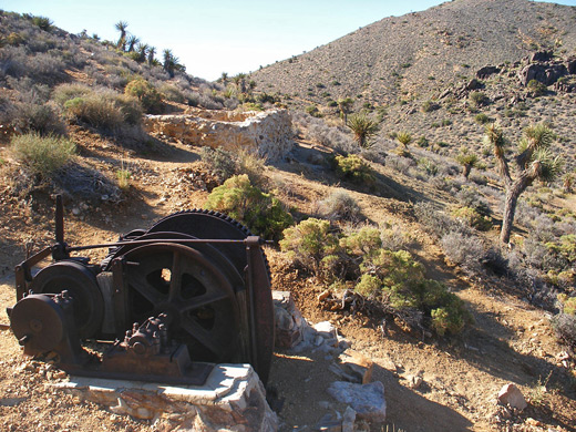
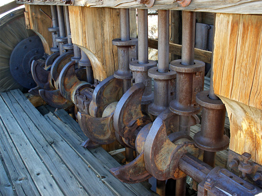
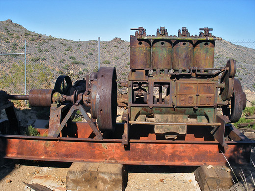
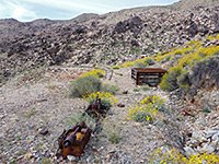
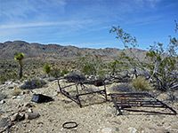
Relics at Lost Horse Mine include wall remnants from several stone cabins, spoil heaps, sealed-off shafts, concrete emplacements, water tanks, old machinery and iron cables, spread out over a few hundred feet of the hillside, which is crossed by various disused tracks. A faint path climbs to the summit above the mine - not quite the highest peak around though good enough for panoramic views over Queen Valley, Pleasant Valley, Wonderland of Rocks and many far off mountain ranges. The ten stamp mill and its foundations have become somewhat unstable so are enclosed by an 8 foot high chain link fence, to protect both the structure and the public, though inevitably several gaps have appeared where people can crawl under and gain access. The mill is built on three levels linked by wooden staircases, and is nearly complete, missing only a higher section at the back (the headframe) that once covered the crushing mechanism. Inside, the thick timbers and heavy ironwork look strong enough to last for many years to come; equipment includes the ten stamps with their associated cams and crankshafts, chutes and hoppers where the ore was channelled, and the recovery table where the precious metals were extracted from the powdered rock.
The ten stamp mill is enclosed by a metal fence for protection, spoiling its appearance somewhat but still the site is evocative, and not at all busy - the walk might be quite gentle but 4 miles is far enough to discourage the casual visitor. Lost Horse Mine opened in 1894, producing good amounts of gold and silver for just over ten years, then lesser quantities up until 1931 when the site was abandoned.
The Trail
The Lost Horse Mine trailhead is reached by an unpaved, mile long side track forking off the road through Lost Horse Valley to Keys View. The track crosses flat, sandy land sprinkled with Joshua trees, ending at a small parking area from where the path begins, heading due east over undulating land bearing scattered cacti, yucca, nolina and wildflowers, though no more Joshua trees. The upwards gradient is never very steep, and the trail gains a moderate 480 feet in the 2 miles to the mine. Views open up after a while, as distant lands to the north and east become visible.
Views
The mine can be seen from about half a mile away, perched on sloping ground just below the top of a hill, near the head of a rocky ravine. The trail climbs up the ravine, past a junction with a short spur to the mine, then continues southeastwards to the top of a ridge, for even better views of the surroundings. From here the route descends a little, turns back west and rises to cross a saddle quite close to the summit of Lost Horse Mountain (5,313 feet). There is another old mine site near the saddle, and a third reached by a side trail a little further on, as the main path drops down into a Joshua tree-studded valley on the west side of the mountain, a drainage that is followed for 2 miles back to the trailhead.
The Mine
Relics at Lost Horse Mine include wall remnants from several stone cabins, spoil heaps, sealed-off shafts, concrete emplacements, water tanks, old machinery and iron cables, spread out over a few hundred feet of the hillside, which is crossed by various disused tracks. A faint path climbs to the summit above the mine - not quite the highest peak around though good enough for panoramic views over Queen Valley, Pleasant Valley, Wonderland of Rocks and many far off mountain ranges. The ten stamp mill and its foundations have become somewhat unstable so are enclosed by an 8 foot high chain link fence, to protect both the structure and the public, though inevitably several gaps have appeared where people can crawl under and gain access. The mill is built on three levels linked by wooden staircases, and is nearly complete, missing only a higher section at the back (the headframe) that once covered the crushing mechanism. Inside, the thick timbers and heavy ironwork look strong enough to last for many years to come; equipment includes the ten stamps with their associated cams and crankshafts, chutes and hoppers where the ore was channelled, and the recovery table where the precious metals were extracted from the powdered rock.
Lost Horse Mine - Similar Hikes
All Contents © Copyright The American Southwest | Comments and Questions | Contribute | Affiliate Marketing Disclosure | Site Map