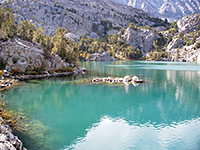
California Hiking Trails
 For details of all California trails featured on this website, see the listings pages:
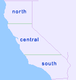
North (41), including Lassen Volcanic National Park, and Redwood National and State Parks
Central (102), including Death Valley National Park, Kings Canyon National Park, Lake Tahoe, Muir Woods National Monument, Sequoia National Park and Yosemite National Park
South (46), including Anza Borrego State Park, Joshua Tree National Park and Mojave National Preserve
Top Ten Trails
Below are suggestions for the top ten hikes in California, in alphabetical order, though there are many similar trails, especially to summits and mountain lakes, that are equally spectacular. Three are from Yosemite, two from Death Valley, two from the Eastern Sierra and the remainder from Lassen Volcanic, Lake Tahoe and the Lost Coast.
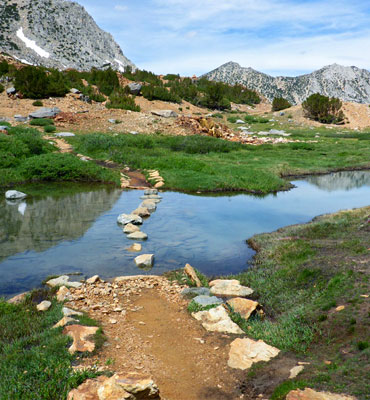
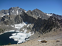
 Length 11 miles (17.7 km), elevation change 3400 feet (1036 meters); for the basic loop Difficulty Strenuous Rating 1-5) ★★★★★ Nine beautiful glacial lakes high up the eastern slopes of the Sierra Nevada, nestled beneath 14,000 foot peaks. Reached by a trail that climbs along the North Fork of Pine Creek, past a waterfall, then starts a loop round six of the lakes. Spur paths lead to the other lakes, and to the base of Palisade Glacier. |
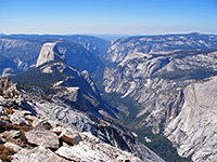 Length 2 miles (3.2 km), elevation change 850 feet (259 meters); from the north Difficulty Moderate Rating 1-5) ★★★★★ Clouds Rest is a rounded granite summit, 1,090 feet higher than the more well known Half Dome but offering similar, if not better, views of Yosemite Valley and countless square miles of the backcountry. The peak can be approached either from the south, starting in the valley, or from the north beginning along the Tioga Road - the southern end of the 5 mile Clouds Rest Trail, which leads to the summit, branches off the John Muir Trail, while the northern terminus is at a junction with the Forsyth Trail. |
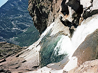
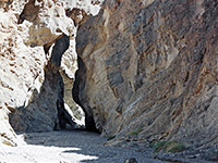 Length 3 miles (4.8 km), elevation change 1200 feet (366 meters); or longer Difficulty Moderate to strenuous - frequent high dryfalls which may either be free-climbed, or bypassed by retreating a way and scaling the steep slopes at either side Rating 1-5) ★★★★★ Perhaps the most beautiful narrows in Death Valley - a long succession of enchanting passages through light-colored rocks, often polished smooth by floodwaters. Many enclosed chambers, dryfalls and chokestones. |
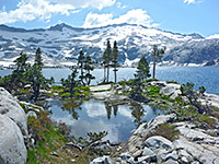 Length 5.1 miles (8.2 km), elevation change 1600 feet (488 meters) Difficulty Strenuous Rating 1-5) ★★★★★ Popular path leading to several beautiful lakes in the Desolation Wilderness, most spectacular being Lake Aloha - a large, shallow, high elevation lake dotted with tiny islands and surrounded on all sides by stark white granite, with very few trees. En route the path passes Susie Lake and Heather Lake. |
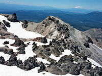 Length 2.4 miles (3.9 km), elevation change 1957 feet (596 meters) Difficulty Strenuous Rating 1-5) ★★★★★ Beginning at an already high elevation of 8,500 feet, the well defined trail up the south face of Lassen Peak gains another 2,000 feet as it switchbacks across a steep slope of stones and lava blocks to the wind-swept summit, from where the 360-degree views extend for 80 miles in some directions. Because of snowfall, the trail is only open for several months each year. |
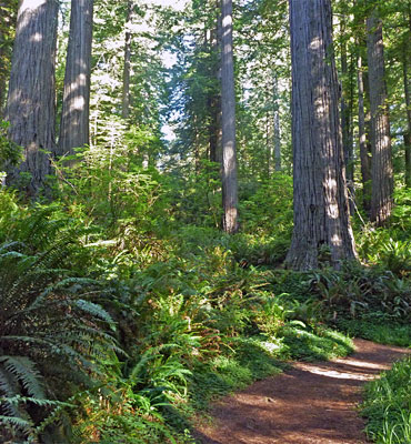
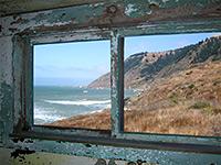 Length 5 miles (8 km), elevation change 100 feet (30 meters) Difficulty Easy to moderate Rating 1-5) ★★★★★ Long distance (25 mile) path between Mattole Beach and Shelter Cove. The northernmost 5 miles pass a good variety of sites including an old lighthouse, abandoned cabins, extensive tidepools and several ravines into the adjacent mountains. |
 Length 3 miles (4.8 km), elevation change 3100 feet (945 meters) Difficulty Strenuous Rating 1-5) ★★★★★ The steep trail to the summit of Mount Dana, Yosemite's second highest peak, is unofficial but well used and easy to follow, at least as far as the start of the scree and boulders that cover the upper 1,000 feet. From the top stretches a stupendous view right across the Sierras, from California's Central Valley to distant mountain ranges in Nevada. The hike begins right next to the national park entrance station along the Tioga Road. |
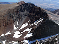
 Length 8.5 miles (13.7 km), elevation change 3800 feet (1158 meters); for the full loop Difficulty Strenuous Rating 1-5) ★★★★★ Spectacular loop hike starting at Onion Valley high up in the eastern Sierra Nevada; climbing steadily past four pretty lakes to 11,760 foot Kearsarge Pass, ascending another 1,240 feet to the summit of Mt Gould then returning via an adjacent canyon containing another large lake. |
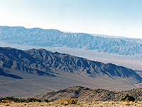 Length 4.2 miles (6.8 km), elevation change 2100 feet (640 meters) Difficulty Easy to moderate Rating 1-5) ★★★★★ High summit in the Panamint Mountains, rising over 9,000 feet on the west side of Death Valley; reached by a steep but straightforward trail, a relatively popular hike in summer. |
 Length 3.6 miles (5.8 km), elevation change 2600 feet (792 meters) Difficulty Strenuous Rating 1-5) ★★★★★ Beginning at the Sunnyside Campground/Camp 4 (shuttle stop 7), this strenuous but well used path climbs the cliffs at the north side of Yosemite Valley, passing over 100 switchbacks, to the top of the highest waterfall in North America. Above the falls is a junction; right is the North Dome Trail, left is the Eagle Peak Trail. |
Location of the Top Ten Hikes
All Contents © Copyright The American Southwest | Comments and Questions | Contribute | Affiliate Marketing Disclosure | Site Map