Alamo Canyon, Organ Pipe Cactus National Monument
Arizona > Organ Pipe Cactus National Monument > Alamo Canyon
Alamo Canyon Trail
Well used path alongside a seasonal wash, passing cottonwood trees and plenty of cacti, to the remains of an old ranch building
Length: 1.3 miles
Elevation change: 130 feet
Difficulty: Easy
Type: One way; continuation, off trail hikes possible further up the valley or the enclosing cliffs
Usage: Medium
Season: All year; short enough to be hiked even in the extreme heat of summer
Trailhead: At the end of the 4 mile Alamo Wash Road
Rating (1-5): ★★★★★

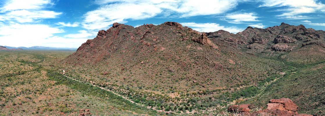
Apart from the Ajo Mountain Drive and the Puerto Blanco Drive, the only other maintained road into the superb backcountry of Organ Pipe Cactus National Monument is to the head of Alamo Canyon; this is one of the larger ravines in the Ajo Range, the jagged mountains that form the eastern boundary of the preserve.
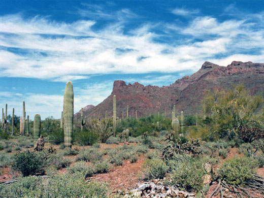
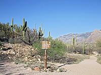
The road is a wide, somewhat bumpy gravel track that leaves AZ 85 between mileposts 65 and 66, and for 4 miles climbs gently to 2,320 feet, crossing desert filled with cacti as varied and densely-growing as any other place in the monument. Organ pipes are plentiful, as are saguaro, opuntia and echinocerei. The track ends at a parking area and a small primitive campground - together with the main site near the visitor center, these are the only two places in the national monument where vehicle-based camping is permitted.
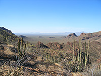
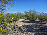
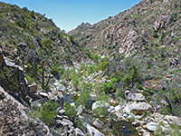
Running parallel to the track just to the south, Alamo Wash is a seasonal stream that only flows after recent rainfall from the nearby canyon, which can be explored by a short footpath. This starts off wide and level - it was once a jeep track, leading through the relatively open land of the lower canyon, past the ruins of an old stone building and a disused well; the walk is easy but has no shade. After about one mile the trail becomes less clearly defined, and merges with the rather overgrown dry streambed. Not far upstream, the main canyon narrows and divides several times. A good vantage point can be obtained by climbing the hillside to the south; this is not too difficult and after ascending a few hundred feet one obtains excellent views over the desert to the west. The cacti on the hillside seem especially pristine and there is also a good selection of wildflowers, but not much sign of wildlife.
The road is a wide, somewhat bumpy gravel track that leaves AZ 85 between mileposts 65 and 66, and for 4 miles climbs gently to 2,320 feet, crossing desert filled with cacti as varied and densely-growing as any other place in the monument. Organ pipes are plentiful, as are saguaro, opuntia and echinocerei. The track ends at a parking area and a small primitive campground - together with the main site near the visitor center, these are the only two places in the national monument where vehicle-based camping is permitted.


Alamo Canyon Trail
Running parallel to the track just to the south, Alamo Wash is a seasonal stream that only flows after recent rainfall from the nearby canyon, which can be explored by a short footpath. This starts off wide and level - it was once a jeep track, leading through the relatively open land of the lower canyon, past the ruins of an old stone building and a disused well; the walk is easy but has no shade. After about one mile the trail becomes less clearly defined, and merges with the rather overgrown dry streambed. Not far upstream, the main canyon narrows and divides several times. A good vantage point can be obtained by climbing the hillside to the south; this is not too difficult and after ascending a few hundred feet one obtains excellent views over the desert to the west. The cacti on the hillside seem especially pristine and there is also a good selection of wildflowers, but not much sign of wildlife.

Alamo Canyon - Similar Hikes
All Contents © Copyright The American Southwest | Comments and Questions | Contribute | Affiliate Marketing Disclosure | Site Map