Red Tanks Tinaja and Senita Basin, Organ Pipe Cactus National Monument
Arizona > Organ Pipe Cactus National Monument > Red Tanks Tinaja and Senita Basin
Red Tanks Tinaja and Senita Basin
Trail from Puerto Blanco Drive, south over flattish land to the seasonal pools of Red Tanks Tinaja, then along a wash into Senita Basin, home to the rare pachycereus schottii cactus
Length: 0.8 miles to the Tanks, 3.2 miles to Senita Basin picnic area
Elevation change: 260 feet
Difficulty: Easy, at cooler times of the year
Type: One way; connects with other trails, including to Baker Mine and Victoria Mine
Usage: Low to medium
Season: Fall to spring; hot in summer
Trailhead: 4 miles along Puerto Blanco Drive. Also accessible from Senita Basin
Rating (1-5): ★★★★★

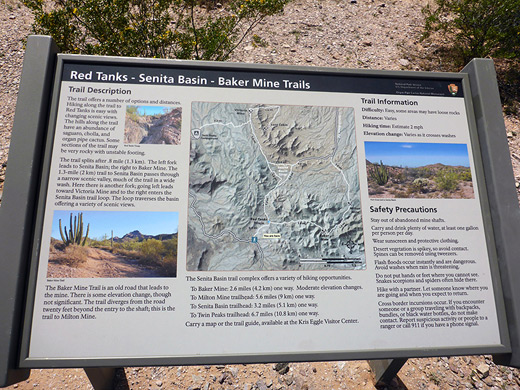
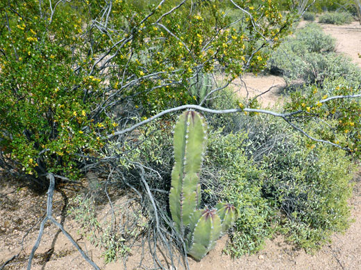
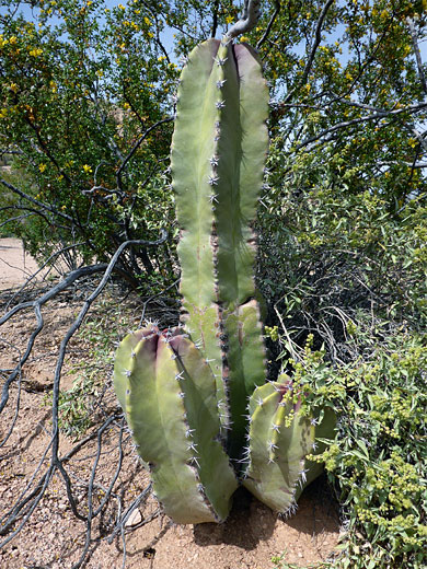
Senita Basin is a sheltered, low elevation area on the south side of the Puerto Blanco Mountains in Organ Pipe Cactus National Monument, home to the rare senita (pachycereus schottii) cactus, while Red Tanks Tinaja is a natural cavity along a small wash on the north side, where water remains for a long time after rainfall. These two locations are linked by a 3.2 mile trail, running between Senita Basin picnic area, at the end of a short spur off the southern section of Puerto Blanco Drive, and a pull-out along the northern section of the drive.
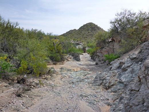
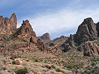
The elevation change is minimal, and the scenery somewhat varied, changing from an open plain in the north, over a low ridge to the enclosed wash downstream of the Tinaja - beneath low summits of the mountains, and the more densely vegetated land of the basin. Even here, senita are not so common, but saguaro are plentiful, and a few organ pipes grow in the rockier areas either side of the wash. Three other paths branch off, allowing for longer hikes - Baker Mine to the west, and two parts of the Senita Basin loop to the east, which lead to other sites, including Victoria Mine. Red Tanks Tinaja is the most popular destination, though none of the trails receive very much use.
Organ Pipe Cactus National Monument map, Red Tanks Tinaja and Senita Basin topographic map.
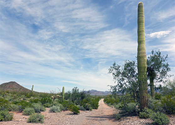
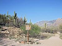
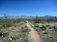
The hike has a well signed trailhead 4 miles along Puerto Blanco Drive, the section which is paved and two-way; the rougher, unpaved, one-way part begins in another mile. Most of the first 0.8 miles (to Red Tanks Tinaja) follows a disused vehicle track that leads eventually to Baker Mine.
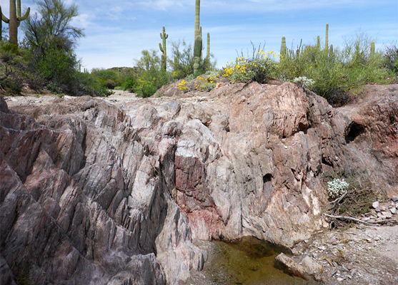
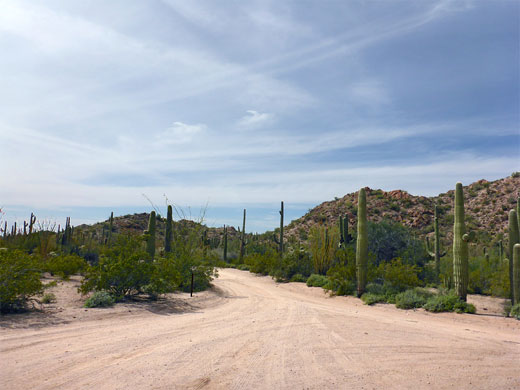
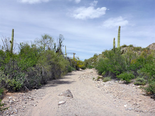
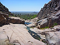
The wide, flat path heads south, past a scattering of saguaro and a few organ pipes, separated by open, sandy patches. It soon meets the old mine road, next to a sign warning of smuggling activity and other desert hazards. The track crosses a small wash while rising gradually to a high point of 1,870 feet, followed by a similarly gentle descent to a larger wash, just above Red Tanks Tinaja, and then a junction on the far side, after 0.8 miles. The Baker Mine Trail is right (west), while the other path returns to the streambed, just below the tanks, where the creek bed falls about eight feet over a bi-colored granitic rock layer, reddish above, grey below. The largest pool is at the base, but other areas are usually wet or at least moist, attracting wildlife including numerous butterflies. The creek at this point is shaded by large trees, and enclosed by flat rocks; ideal places to sit and rest for a while.
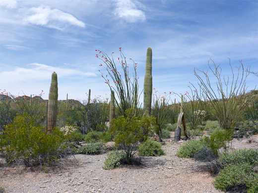
The wash below the tinaja has a gravel or sandy floor, quite firm, so walking downstream remains easy. The streambed curves round a little bend, bordered to one side by an earthen cliff, then is fairly straight, running beneath low ridges and peaks of the Puerto Blanco Mountains. A concrete barrier partially blocks the creekbed at one point, soon after which the trail leaves the wash by climbing up the east side to a flat, white sand plateau, continuing south across a couple of minor tributaries and onto the edge of Senita Basin. 0.3 miles after leaving the wash, the path reaches a junction with the north section of the Senita Basin loop trail, signed 1.1 miles (right fork) to the parking area. This path is nearly level, crossing the middle of the basin while heading generally southwest, initially still close to the wash then over flatter ground, past two more small drainages to a second junction with the loop trail, 0.2 miles before the parking/picnic area. Tailings piles from Martinez Mine are visible part of the way up the hills to the southeast, reachable by walking 0.6 miles on the eastwards section of the loop path, and 0.3 miles cross-country. The final 0.2 miles to the parking area are through bushier ground, where plants include the elephant tree, and a few senita, most often found nestled beside trees and bushes for protection.
The elevation change is minimal, and the scenery somewhat varied, changing from an open plain in the north, over a low ridge to the enclosed wash downstream of the Tinaja - beneath low summits of the mountains, and the more densely vegetated land of the basin. Even here, senita are not so common, but saguaro are plentiful, and a few organ pipes grow in the rockier areas either side of the wash. Three other paths branch off, allowing for longer hikes - Baker Mine to the west, and two parts of the Senita Basin loop to the east, which lead to other sites, including Victoria Mine. Red Tanks Tinaja is the most popular destination, though none of the trails receive very much use.
Maps
Organ Pipe Cactus National Monument map, Red Tanks Tinaja and Senita Basin topographic map.
Red Tanks Tinaja Trailhead
The hike has a well signed trailhead 4 miles along Puerto Blanco Drive, the section which is paved and two-way; the rougher, unpaved, one-way part begins in another mile. Most of the first 0.8 miles (to Red Tanks Tinaja) follows a disused vehicle track that leads eventually to Baker Mine.
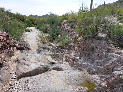
Red Tanks Tinaja
The wide, flat path heads south, past a scattering of saguaro and a few organ pipes, separated by open, sandy patches. It soon meets the old mine road, next to a sign warning of smuggling activity and other desert hazards. The track crosses a small wash while rising gradually to a high point of 1,870 feet, followed by a similarly gentle descent to a larger wash, just above Red Tanks Tinaja, and then a junction on the far side, after 0.8 miles. The Baker Mine Trail is right (west), while the other path returns to the streambed, just below the tanks, where the creek bed falls about eight feet over a bi-colored granitic rock layer, reddish above, grey below. The largest pool is at the base, but other areas are usually wet or at least moist, attracting wildlife including numerous butterflies. The creek at this point is shaded by large trees, and enclosed by flat rocks; ideal places to sit and rest for a while.
Senita Basin
The wash below the tinaja has a gravel or sandy floor, quite firm, so walking downstream remains easy. The streambed curves round a little bend, bordered to one side by an earthen cliff, then is fairly straight, running beneath low ridges and peaks of the Puerto Blanco Mountains. A concrete barrier partially blocks the creekbed at one point, soon after which the trail leaves the wash by climbing up the east side to a flat, white sand plateau, continuing south across a couple of minor tributaries and onto the edge of Senita Basin. 0.3 miles after leaving the wash, the path reaches a junction with the north section of the Senita Basin loop trail, signed 1.1 miles (right fork) to the parking area. This path is nearly level, crossing the middle of the basin while heading generally southwest, initially still close to the wash then over flatter ground, past two more small drainages to a second junction with the loop trail, 0.2 miles before the parking/picnic area. Tailings piles from Martinez Mine are visible part of the way up the hills to the southeast, reachable by walking 0.6 miles on the eastwards section of the loop path, and 0.3 miles cross-country. The final 0.2 miles to the parking area are through bushier ground, where plants include the elephant tree, and a few senita, most often found nestled beside trees and bushes for protection.
Red Tanks Tinaja and Senita Basin - Similar Hikes
All Contents © Copyright The American Southwest | Comments and Questions | Contribute | Affiliate Marketing Disclosure | Site Map