McKittrick Canyon Trail, Guadalupe Mountains National Park
Texas > Guadalupe Mountains National Park > Hiking > McKittrick Canyon Trail
McKittrick Canyon Trail
Popular path along the most scenic canyon in Guadalupe Mountains National Park, where a stream flows year-round, sustaining abundant vegetation and wildlife. Other highlights are two historic cabins and a limestone grotto
Length: 3.4 miles, to the grotto
Elevation change: 400 feet
Difficulty: Easy
Type: One way. Trail continues by climbing steeply at the upper end of the canyon, eventually joining the Tejas Trail
Usage: Medium
Season: All year; best in spring when the water is flowing most strongly
Trailhead: End of a paved side road off US 62/180
Rating (1-5): ★★★★★

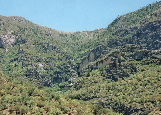
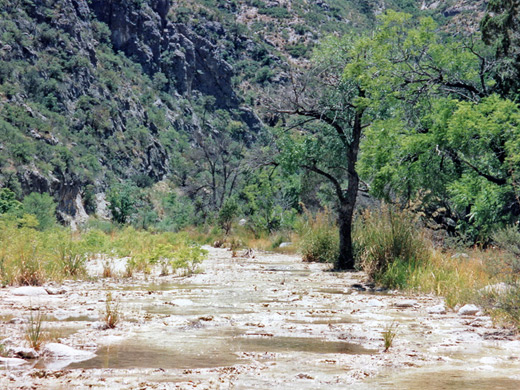
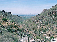
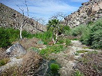
The hike up McKittrick Canyon, near the eastern edge of Guadalupe Mountains National Park, offers something for everyone; the drainage has a varied mixture of vegetation, quite plentiful wildlife and several historic sites. The path is at first shaded, level and easy, then after four miles becomes exposed and more challenging, linking with other back-country routes suitable for overnight back-packing trips. The first part of the path follows McKittrick Creek, which is unusual in that it flows all year but often partially underground so only short, separated sections have permanent water.
McKittrick Canyon Trail topographic map, Guadalupe Mountains location map.
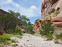
McKittrick Canyon is separate from the main park area, and is reached by a short side road off US 62/180. The road ends at an unstaffed visitor center, parking area and picnic site. The creek bed runs past and continues westwards away from the mountains, eventually joining the Pecos River, but is usually dry at this point. The trail is initially along the streamway, then winds along the sandy banks at either side, crossing the creek several times. At first the plants are typical of the Chihuahuan Desert with yucca, agaves and opuntia cacti, but with some pine/juniper trees that become quickly more abundant in the moister, cooler environment up the canyon and are joined by ash, oak and bigtooth maple, leafs of which show beautiful red-orange leaf colors during fall. A more unusual tree is the Texas madrone, a distinctive species with red-colored bark and evergreen leaves.
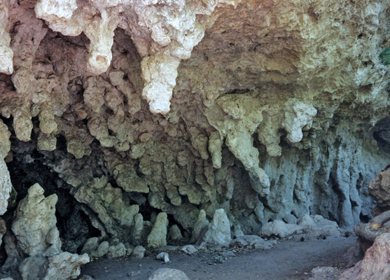
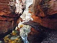
After 2.4 miles the path reaches the first of two historic cabins (Pratt Lodge, built in the 1930s), part of a small group of wooden buildings beneath shady trees, intermittently open to the public. Drinking water is available. Upstream of this location the creek flows even in summer, rising above ground at several points between rock layers, then returning below ground a several hundred feet further. Shortly beyond the cabin, the path crosses into the official wilderness region, becomes a little more rocky and passes several features of interest such as various pools with medium-sized fish, a grotto in a cavity beneath a limestone cliff with stalagmite-like formations, and the second old dwelling (Hunter Line Cabin, reached by a short spur trail). This is boarded up and not occupied, except by groups of bats that hang upside down from the ceiling during the day.
The Hunter cabin is the usual point visited on a day hike, and is 3.4 miles from the start of the trail. Ahead, the canyon becomes quite steep and the path climbs nearly 2,000 feet over the next 2 miles to McKittrick Ridge at 7,716 feet, then continues through the forest, eventually joining the long Tejas Trail, four miles from the northern entrance to Guadalupe Mountains National Park at Dog Canyon.
Maps
McKittrick Canyon Trail topographic map, Guadalupe Mountains location map.
Start of the Trail
McKittrick Canyon is separate from the main park area, and is reached by a short side road off US 62/180. The road ends at an unstaffed visitor center, parking area and picnic site. The creek bed runs past and continues westwards away from the mountains, eventually joining the Pecos River, but is usually dry at this point. The trail is initially along the streamway, then winds along the sandy banks at either side, crossing the creek several times. At first the plants are typical of the Chihuahuan Desert with yucca, agaves and opuntia cacti, but with some pine/juniper trees that become quickly more abundant in the moister, cooler environment up the canyon and are joined by ash, oak and bigtooth maple, leafs of which show beautiful red-orange leaf colors during fall. A more unusual tree is the Texas madrone, a distinctive species with red-colored bark and evergreen leaves.
Cabins and a Grotto
After 2.4 miles the path reaches the first of two historic cabins (Pratt Lodge, built in the 1930s), part of a small group of wooden buildings beneath shady trees, intermittently open to the public. Drinking water is available. Upstream of this location the creek flows even in summer, rising above ground at several points between rock layers, then returning below ground a several hundred feet further. Shortly beyond the cabin, the path crosses into the official wilderness region, becomes a little more rocky and passes several features of interest such as various pools with medium-sized fish, a grotto in a cavity beneath a limestone cliff with stalagmite-like formations, and the second old dwelling (Hunter Line Cabin, reached by a short spur trail). This is boarded up and not occupied, except by groups of bats that hang upside down from the ceiling during the day.
McKittrick Ridge
The Hunter cabin is the usual point visited on a day hike, and is 3.4 miles from the start of the trail. Ahead, the canyon becomes quite steep and the path climbs nearly 2,000 feet over the next 2 miles to McKittrick Ridge at 7,716 feet, then continues through the forest, eventually joining the long Tejas Trail, four miles from the northern entrance to Guadalupe Mountains National Park at Dog Canyon.
McKittrick Canyon Trail - Similar Hikes
All Contents © Copyright The American Southwest | Comments and Questions | Contribute | Affiliate Marketing Disclosure | Site Map