Highlights:
Small area of the Organ Mountains, overlooking White Sands and Tularosa Valley; lightly wooded slopes rising to jagged granite peaks. Park has a popular campground and several trails
Nearby town:
Las Cruces, 20 miles
Management:
Location:
Seasons:
Open all year. Spring and fall are the most popular times
Rating (1-5):
★★★★★

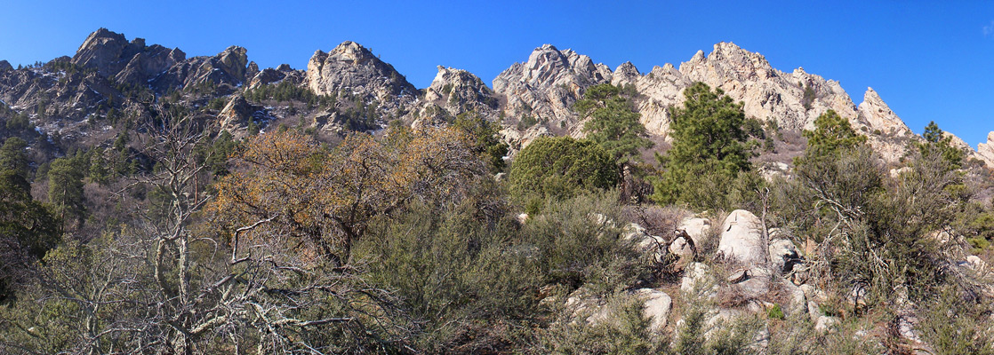
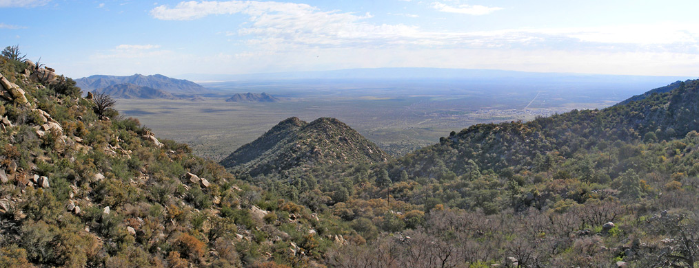
The Organ Mountains are a compact range a few miles east of Las Cruces, forming a southerly extension of the much larger San Andres Mountains - both create a natural divide between Rio Grande Valley in the west and Tularosa Valley in the east, much of which is contained within White Sands Missile Base. The most spectacular section of the Organ Mountains are the Needles, a jagged ridge of eroded granite pinnacles, and this provides a scenic backdrop to the BLM-managed Aguirre Spring Recreation Area, situated in a sheltered bowl on the northeast-facing side of the ridge.
The site contains a campground, at elevation 5,700 feet and hence significantly cooler than the desert lowlands, plus two trails, and the proximity to both Las Cruces and El Paso makes the place very popular. Entry and/or camping are good value at just $5 or $7 respectively (in 2024), and although the campsite has few facilities, and is not suitable for large RVs, the pleasant surroundings and good views over the mountains and Tularosa Valley are reason enough to stay. As of 2014, all this area is within Organ Mountains-Desert Peaks National Monument.
The site contains a campground, at elevation 5,700 feet and hence significantly cooler than the desert lowlands, plus two trails, and the proximity to both Las Cruces and El Paso makes the place very popular. Entry and/or camping are good value at just $5 or $7 respectively (in 2024), and although the campsite has few facilities, and is not suitable for large RVs, the pleasant surroundings and good views over the mountains and Tularosa Valley are reason enough to stay. As of 2014, all this area is within Organ Mountains-Desert Peaks National Monument.
Aguirre Spring Table of Contents
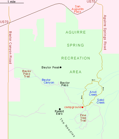
Map of Aguirre Spring Recreation Area
Access and Facilities at Aguirre Spring
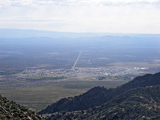
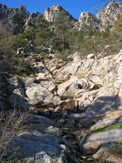
Aguirre Spring Recreation Area is reached by a paved road leaving US 70 just east of San Augustin Pass (15 miles from Las Cruces), right at the edge of White Sands Missile Base; the road is fairly straight at first, descending a little and passing the residence of the campsite host, then becomes narrow and winding, and starts a 3.5 mile, one-way loop across the boulder-strewn lower slopes of the mountains, 3,000 feet below the sharp peaks of the Needles. The campground is half way along, and has 57 sites, most along a short side road and fairly close together so this area is often rather crowded, and noisy, but there are several more sites at intervals further along the road which are less used and more peaceful. The surrounding land is dotted with weathered granite boulders, partly covered in lichen, and has vegetation from the transition zone between the Chihuahuan Desert and the pinyon pine/juniper belt, including cacti, yucca, sotol, mahogany and gray oak. Views to the northeast are of the edge of Tularosa Valley and the White Sands Missile Base headquarters, while the other directions are dominated by the steep-sided Organ Mountains, curving round the campsite and causing the sun to disappear relatively early, so evenings may be quite cool even in summer. Higher up, patches of snow remain until May or June. Two hikes start along the road; the longest is the 6 mile Baylor Pass Trail, a one-way route right across the mountains to Baylor Canyon Road on the west side, but the most people choose the 4 mile (loop) Pine Tree Trail, which climbs 1,100 feet further up the slopes and has excellent views all the way.
Pine Tree Trail
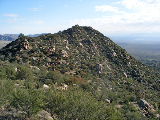
The trailhead sign, information notice and register for the 4 mile Pine Tree Trail are along the loop road just east of the main section of the campground. The path splits after a short distance; the left (east) branch is quite shady, the right fork more exposed and has better views, and both are equally steep, but the clockwise direction is probably the best. The surface is rather stony and some of the steeper sections can be slippery, though overall the trail is well used, easy to follow, and the 4 miles takes around 2 hours. The left path soon crosses three streams, each flowing down a ravine of granite boulders and slickrock, in places polished white by the waters, then climbs up to a saddle for the first good views of the Tularosa Valley far below. It ascends further across several ridges, veers to the west back across the streams and up to a grassy area at the high point of the loop, a location marked by a sign. A primitive campsite is located close by. Above, the summits of the Needles are at least 1,500 feet higher, but the base of the peaks looks relatively easy to reach since the ground is fairly open, without any sheer cliffs, just steep, grassy slopes with scattered trees and boulders. The path continues, now descending, across a few minor drainages and over hillsides that have fewer trees than before and so give better vistas. The last part of the trail is more overgrown and a little harder to identify because various smaller paths criss-cross the main route.
Aguirre Spring - Nearby Places
- Franklin Mountains State Park, Texas (53 miles) - Chihuahuan Desert range within El Paso city limits
- White Sands National Park (36 miles) - spectacular dunes of white gypsum
Aguirre Spring - Similar Places
- Castle Crags State Park - granite cliffs and pinnacles in far north California
- Granite Mountain, Arizona - wooded granite peak near Prescott, good for hiking
All Contents © Copyright The American Southwest | Comments and Questions | Contribute | Affiliate Marketing Disclosure | Site Map