West Rim Trail
Longest trail in the national park, linking Lava Point with the floor of Zion Canyon. The southernmost section is the most spectacular, climbing via Refrigerator Canyon to Scout Lookout near Angels Landing, then ascending further alongside Telephone Canyon to the wooded Horse Pasture Plateau
Length: 4.7 miles to Cabin Spring; 14.5 miles for the full trail
Elevation change: 2,500, 3,200 feet
Difficulty: Strenuous
Type: One way
Usage: High to Scout Lookout; low to medium beyond
Season: Spring, summer, fall
Trailhead: The Grotto - shuttle stop 6, or along a track from Lava Point
Rating (1-5): ★★★★★
Elevation change: 2,500, 3,200 feet
Difficulty: Strenuous
Type: One way
Usage: High to Scout Lookout; low to medium beyond
Season: Spring, summer, fall
Trailhead: The Grotto - shuttle stop 6, or along a track from Lava Point
Rating (1-5): ★★★★★

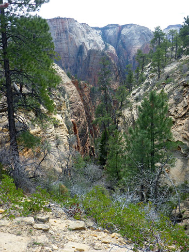
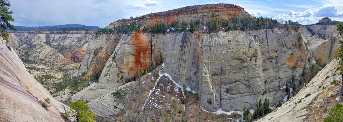
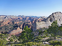
Zion National Park's longest hike is the West Rim Trail, starting near the highest place in the park (7,890 foot Lava Point) and ending on the floor of Zion Canyon after 14.5 miles and a drop of 3,200 feet. The upper few miles are relatively level, crossing the forested Horse Pasture Plateau, within sight of deep canyons to the east and west; the main elevation change starts on the southeast edge of the plateau, where the path descends to the pretty valley of Telephone Canyon then follows a narrow ridge overlooking Zion Canyon, to a junction with the spur to Angels Landing. The last section is steep once more, switchbacking down to the Virgin River, and also much busier, used by people on the way to Angels Landing - the upper reaches are much less used, especially on the plateau.
The best option is a one way hike from north to south, but this requires a car shuttle, the two trailheads being 37 miles (an 80 minute drive) away by road plus another 4.5 miles by shuttlebus. There are several companies in Springdale who provide such services. Some people take two days for the hike, staying at one of nine designated primitive camping sites, all on Horse Pasture Plateau, where three springs provide drinking water.
Alternatively, the upper and lower sections of the trail can be seen by separate day hikes, a natural dividing point being the south edge of the plateau; while the southern half of the path is most spectacular, the northern part is still very good, an option perhaps for a trip in the hot days of summer, as all the area is over 7,000 feet and therefore somewhat cooler.
West Rim Trail topographic map, location map for Zion Canyon.
32 views along the West Rim and Angels Landing Trails.
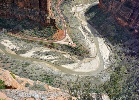
The northern West Rim trailhead is 1.5 miles along a track branching off the side road to Lava Point; this descends a little through thickly wooded land beneath the point, to a small parking area just before a gate - the track continues to a private camping facility, and is also used to reach several deep slot canyons such as Kolob Creek. The Wildcat Canyon Trail also starts here, descending 1,000 feet over 6 miles to an intersection with the Kolob Reservoir Road, but the West Rim Trail is the main route. The southern terminus of this trail is beside the Virgin River in Zion Canyon, near the Grotto Picnic Area stop on the shuttle bus service, 4.5 miles from the visitor center and half a mile from Zion Lodge.
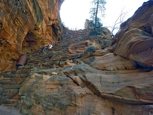
Starting by the side of the road in Zion Canyon, a sturdy footbridge takes the trail over the Virgin River to a junction, left being the Kayenta Trail which leads to the popular Emerald Pools, one mile away. The other branch heads north, through wooded surroundings, staying level and close to the river, which can be reached by several smaller paths that descend to the water's edge. The West Rim Trail becomes paved once the climbing starts, with a few wide bends as the route approaches the sheer Navajo sandstone cliffs on the west side of Zion Canyon, then traverses the talus slope at the base. The next section is much steeper, as a series of switchbacks climb 320 feet up an exposed slope to the mouth of Refrigerator Canyon, a deep, narrow, shady drainage, similar to many such canyons in the park, being straight, sheer-walled and starting abruptly at the upper end with a high dryfall.
The West Rim Trail turns away northwards, following the streambed a short way before another series of zig-zags (Walter's Wiggles), gaining another 400 feet, out of the confined canyon to a narrow saddle with expansive views east and west. This is Scout Lookout, where the half mile Angels Landing spur forks off southwards. Some people go no further but most climb at least to the first secondary summit on the Angels Landing route; only about one percent continue on the West Rim Trail.
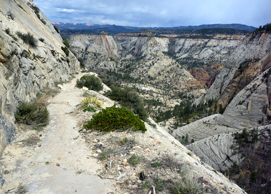
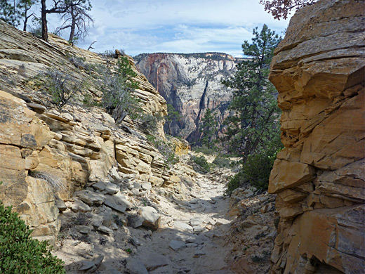
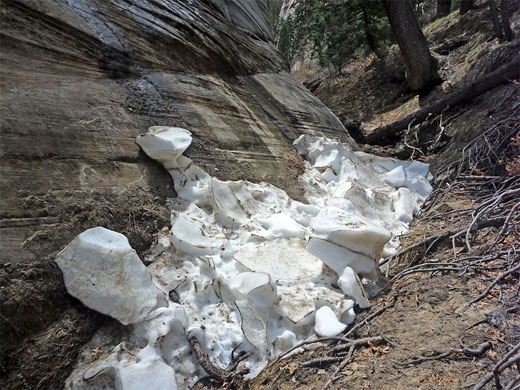
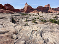
From Scout Lookout, the trail has a few gentle climbs between more level parts, over white or light yellow slickrock mixed with patches of sand, all the time with good views east over Zion Canyon and west over Refrigerator Canyon to the slickrock slopes of Cathedral Mountain. The path stays on or near the crest of the same narrow ridge that terminates in Angels Landing, before moving slightly west to avoid a minor summit, and coming close to the very upper end of Refrigerator Canyon. Near here, a faint, hiker-made trail forks off towards another, unnamed ravine, between Mount Majestic and the north end of Cathedral Mountain; this is narrow and quite photogenic though not a proper slot canyon, and it holds snow quite late in the season.
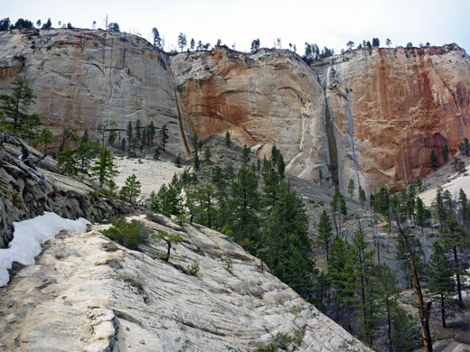
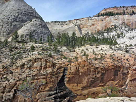
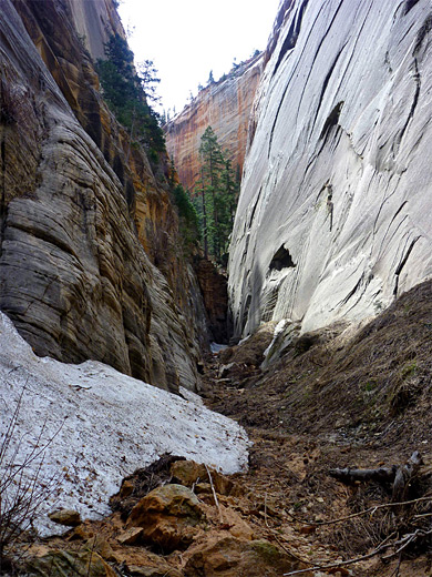
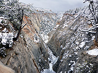
The West Rim Trail descends about 350 feet via a few switchbacks, into a pretty, partly wooded basin fed by several drainages, the main one being Telephone Canyon, which originates on Horse Pasture Plateau above; the white slickrock cliffs at the edge of the plateau are now clearly visible ahead. The path crosses a lesser, red-walled drainage on a footbridge and starts to rise again, beneath the north face of Mount Majestic, into another valley, where the surroundings become more overgrown. Tall, streaked, red and white cliffs (an area known as Little Siberia) enclose the drainage on both sides. A longer straight section is followed by several switchbacks - another place where winter snow lingers - as the trail reaches a saddle at the head of Behunin Canyon to the south, one of Zion's major technical canyoneering locations.
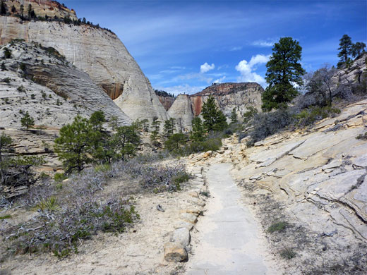
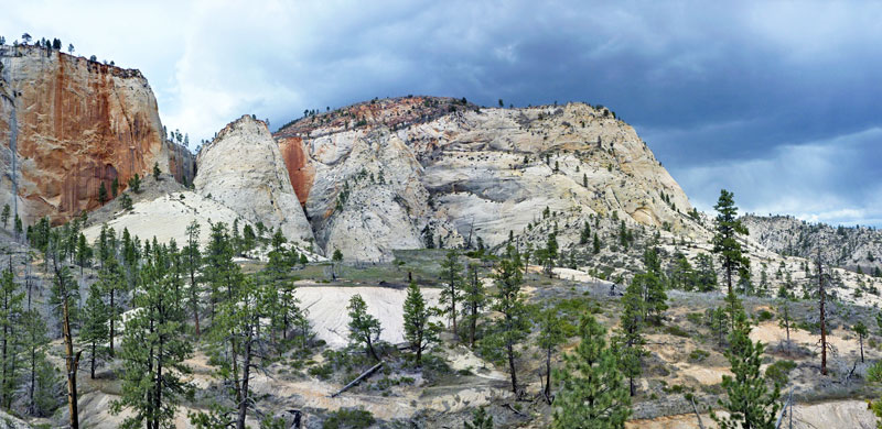
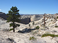
The final major climb (400 feet) on the West Rim Trail is up the white cliffs to Horse Pasture Plateau, most of which is quite thickly wooded. There is no particular viewpoint at the top but the scenery is spectacular, ranging from Mount Majestic in the foreground to distant peaks enclosing the upper end of the Virgin River. The trail reaches a four-way junction once on the plateau; one branch is a short spur to Cabin Spring, while the other two forks cross the plateau, meeting again after 2.8 miles (west) or 1.8 miles (east). The former has the best views and is most traveled despite being longer; it crosses to the west side of the plateau, traversing sloping land high above Phantom Valley and the Right Fork of North Creek. The other trail follows the shallow upper reaches of Telephone Canyon, with more limited views. From the northern junction, the West Rim Trail continues another 7 miles to the trailhead near Lava Point, moving back to the east side of the plateau, over the upper end of Imlay Canyon (Potato Hollow) then along the crest of a low ridge all the way to the end point.
The best option is a one way hike from north to south, but this requires a car shuttle, the two trailheads being 37 miles (an 80 minute drive) away by road plus another 4.5 miles by shuttlebus. There are several companies in Springdale who provide such services. Some people take two days for the hike, staying at one of nine designated primitive camping sites, all on Horse Pasture Plateau, where three springs provide drinking water.
Alternatively, the upper and lower sections of the trail can be seen by separate day hikes, a natural dividing point being the south edge of the plateau; while the southern half of the path is most spectacular, the northern part is still very good, an option perhaps for a trip in the hot days of summer, as all the area is over 7,000 feet and therefore somewhat cooler.
Maps
West Rim Trail topographic map, location map for Zion Canyon.
Photographs
32 views along the West Rim and Angels Landing Trails.
West Rim Trailheads
The northern West Rim trailhead is 1.5 miles along a track branching off the side road to Lava Point; this descends a little through thickly wooded land beneath the point, to a small parking area just before a gate - the track continues to a private camping facility, and is also used to reach several deep slot canyons such as Kolob Creek. The Wildcat Canyon Trail also starts here, descending 1,000 feet over 6 miles to an intersection with the Kolob Reservoir Road, but the West Rim Trail is the main route. The southern terminus of this trail is beside the Virgin River in Zion Canyon, near the Grotto Picnic Area stop on the shuttle bus service, 4.5 miles from the visitor center and half a mile from Zion Lodge.
Start of the Trail
Starting by the side of the road in Zion Canyon, a sturdy footbridge takes the trail over the Virgin River to a junction, left being the Kayenta Trail which leads to the popular Emerald Pools, one mile away. The other branch heads north, through wooded surroundings, staying level and close to the river, which can be reached by several smaller paths that descend to the water's edge. The West Rim Trail becomes paved once the climbing starts, with a few wide bends as the route approaches the sheer Navajo sandstone cliffs on the west side of Zion Canyon, then traverses the talus slope at the base. The next section is much steeper, as a series of switchbacks climb 320 feet up an exposed slope to the mouth of Refrigerator Canyon, a deep, narrow, shady drainage, similar to many such canyons in the park, being straight, sheer-walled and starting abruptly at the upper end with a high dryfall.
Angels Landing Junction
The West Rim Trail turns away northwards, following the streambed a short way before another series of zig-zags (Walter's Wiggles), gaining another 400 feet, out of the confined canyon to a narrow saddle with expansive views east and west. This is Scout Lookout, where the half mile Angels Landing spur forks off southwards. Some people go no further but most climb at least to the first secondary summit on the Angels Landing route; only about one percent continue on the West Rim Trail.
Scout Lookout to Telephone Canyon
From Scout Lookout, the trail has a few gentle climbs between more level parts, over white or light yellow slickrock mixed with patches of sand, all the time with good views east over Zion Canyon and west over Refrigerator Canyon to the slickrock slopes of Cathedral Mountain. The path stays on or near the crest of the same narrow ridge that terminates in Angels Landing, before moving slightly west to avoid a minor summit, and coming close to the very upper end of Refrigerator Canyon. Near here, a faint, hiker-made trail forks off towards another, unnamed ravine, between Mount Majestic and the north end of Cathedral Mountain; this is narrow and quite photogenic though not a proper slot canyon, and it holds snow quite late in the season.
Behunin Canyon
The West Rim Trail descends about 350 feet via a few switchbacks, into a pretty, partly wooded basin fed by several drainages, the main one being Telephone Canyon, which originates on Horse Pasture Plateau above; the white slickrock cliffs at the edge of the plateau are now clearly visible ahead. The path crosses a lesser, red-walled drainage on a footbridge and starts to rise again, beneath the north face of Mount Majestic, into another valley, where the surroundings become more overgrown. Tall, streaked, red and white cliffs (an area known as Little Siberia) enclose the drainage on both sides. A longer straight section is followed by several switchbacks - another place where winter snow lingers - as the trail reaches a saddle at the head of Behunin Canyon to the south, one of Zion's major technical canyoneering locations.
Horse Pasture Plateau
The final major climb (400 feet) on the West Rim Trail is up the white cliffs to Horse Pasture Plateau, most of which is quite thickly wooded. There is no particular viewpoint at the top but the scenery is spectacular, ranging from Mount Majestic in the foreground to distant peaks enclosing the upper end of the Virgin River. The trail reaches a four-way junction once on the plateau; one branch is a short spur to Cabin Spring, while the other two forks cross the plateau, meeting again after 2.8 miles (west) or 1.8 miles (east). The former has the best views and is most traveled despite being longer; it crosses to the west side of the plateau, traversing sloping land high above Phantom Valley and the Right Fork of North Creek. The other trail follows the shallow upper reaches of Telephone Canyon, with more limited views. From the northern junction, the West Rim Trail continues another 7 miles to the trailhead near Lava Point, moving back to the east side of the plateau, over the upper end of Imlay Canyon (Potato Hollow) then along the crest of a low ridge all the way to the end point.
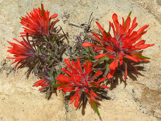
West Rim Wildflower
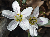 Castilleja scabrida |
West Rim Trail - Similar Hikes
All Contents © Copyright The American Southwest | Comments and Questions | Contribute | Affiliate Marketing Disclosure | Site Map