Boulder Mail Trail, Grand Staircase-Escalante National Monument
Utah > Grand Staircase-Escalante National Monument > Boulder Mail Trail

Boulder Mail Trail
Historic cross-country trail, once the only link between Escalante and Boulder, and also the route of a cable system built in the 1930s. The cairned path crosses three major drainages (Sand Creek, Death Hollow, Mamie Creek), extensive slickrock benches, and several partly wooded plateaus. Amongst the many possible side trips is to Mamie Creek Natural Bridge
Length: (from the Boulder trailhead) 2.5 miles to Sand Creek, 5.6 miles to Death Hollow, 8.3 miles to Mamie Creek, 14.5 miles to Escalante. Another 0.8 miles to Mamie Creek Bridge
Elevation change: 1,140 feet overall, 4,500 feet cumulative
Difficulty: Strenuous
Type: One way, or part of longer loops up or down the drainages
Usage: Low
Season: Spring and fall; summers are hot, and much of the route is exposed. Water levels may be too high in winter
Trailhead: Escalante - end of a short track off Hwy 12. Boulder - beside Boulder Landing Strip, south of Hells Backbone Road
Rating (1-5): ★★★★★

Prior to the construction of Hwy 12 in the 1930s, travel between the towns of Escalante and Boulder was via a winding, cross country route over plateaus, slickrock slopes and several deep canyons, and most is still in use as the Boulder Mail Trail, the longest (semi-)maintained path in Grand Staircase-Escalante National Monument. Parts of the trail parallel an old telegraph wire, installed in 1910; long disused but still intact over much of its length. The western trailhead is close to the Escalante River, just east of Escalante town, while the east end is near Boulder Airstrip, 3 miles from Boulder; both are just a short drive from the highway.
The distance between the two trailheads is 14.5 miles, so the hike could be completed in one day with a vehicle shuttle, and a commercial shuttle service is available in Escalante. The usual practice is to leave a car in Escalante, take the shuttle or drive another vehicle to the Boulder trailhead and hike back, since this direction involves less elevation gain. The east end of the path is 1,140 feet higher than the west end, while the cumulative elevation change along the whole route is about 4,500 feet (1,700 feet up, 2,800 feet down), owing to several steep climbs in and out of drainages.
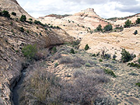
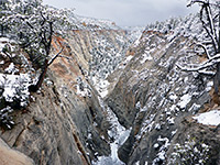
Once past the Escalante River and the tributary of Pine Creek, the westernmost few miles are not so interesting, crossing generally low relief land and small washes, so the eastern trailhead is also the preferred start point for shorter, there-and-back hikes, and the most popular destination is Death Hollow, reached after 5.6 miles. This is the largest drainage along the trail, and contains a year-round stream flowing through a dramatic canyon up to 900 feet deep, between vertical cliffs of whitish Navajo sandstone, the same rock exposed along most of the trail; only at the highest elevations is the overlying Carmel Formation visible.
If water levels are not too high, Death Hollow can be followed up or down stream, potentially all the way to Hell's Backbone Road in the north or the Escalante River in the south, and together with several other drainages, principally Sand Creek and Mamie Creek, the Mail Trail can form part of various multi-day, backpacking loops. The trail itself is obvious in some places - through vegetated areas, along the floor of Death Hollow (for 0.8 miles), and in and out of other canyons, but is less apparent where it crosses large areas of slickrock. All the route is marked by cairns, but some are quite far apart.
From the east, the trail passes through flattish, wooded land to the edge of a plateau, descends across slickrock to the permanent drainage of Sand Creek (2.5 miles), traverses a partly sandy ridge, then descends again, much more steeply, into Death Hollow. On the far side, a steep climb leads up and over another wooded flat and down to the lesser drainage of Mamie Creek (8.3 miles). The next 4 miles are over more gently undulating land including several smaller ravines, before a short but steep descent to Pine Creek, from where the Escalante River and the western end of the path are not far ahead. Amongst many possible side trips is to Mamie Creek Natural Bridge, 0.8 miles downstream of the trail crossing - this unusual feature has formed where the (seasonal) creek has eroded a keyhole-shaped opening through a protruding fin, on the brink of a dryfall.
The Escalante trailhead is at the end of a 0.9 mile track which forks off Hwy 12 on the east side of town, near the local high school and the cemetery; from here, the path heads north, approaching the Escalante River in a quarter of a mile. The eastern trailhead is reached by driving 650 feet along Hells Backbone Road, which leaves the highway 3 miles west of Boulder, then half a mile south on a narrower track that crosses the national monument boundary, soon followed by Boulder Airstrip, and ends at a clearing surrounded by small trees. This track is stony and rutted in parts, so large vehicles may have to be parked along Hells Backbone Road. Free, primitive camping is allowed anywhere hereabouts, except in the vicinity of the airstrip.
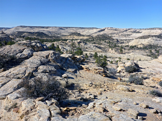
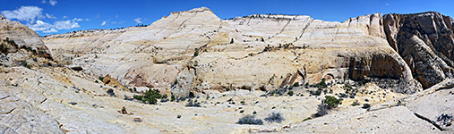
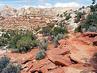
The Boulder trailhead has a register and several informative notices. The original course of the Boulder Mail route is south, along a fainter continuation of the approach track, but the first mile or so of the trail takes a different course, first heading west for a short distance then southwest, through sparse forest, over land covered with blackish basalt boulders, all the while descending gently. The path runs along a little wash for a while, leaving it just before a minor pour-off, then traverses a sagebrush flat, and returns to wooded land, as the ground becomes more sandy. After a preliminary descent, down a low cliff and across a sandy basin, the path reaches the rim of the plateau, where the forest stops abruptly and ground falls away steeply to the west. For the remaining 12.5 miles to Escalante, the majority of land is bare slopes and domes of Navajo sandstone, interrupted by just a few short, sandy, wooded patches, at the higher elevations.
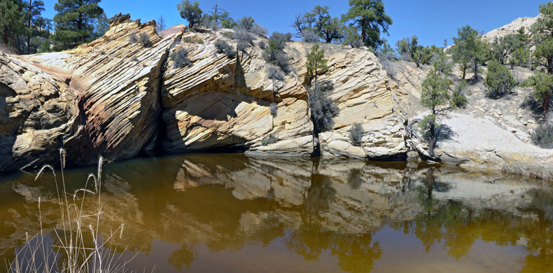
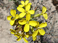
The trail descends a curving slope, passing some small, eroded formations, and moves west into a wide, shallow drainage with a few sandy potholes, that leads to Sand Creek. Amongst the predominantly white rocks are a few more colorful areas, of yellow and brown, and some thin-layered patches crossed with parallel red or pink lines. Bright, red-flowered Indian paintbrush grows in crevices, making a striking contrast to the lighter-colored bedrock. Sand Creek is narrow and fast-moving, flowing through a narrow corridor of bushes and trees but otherwise not overgrown, along a canyon that is relatively shallow, enclosed by slopes rather than cliffs.
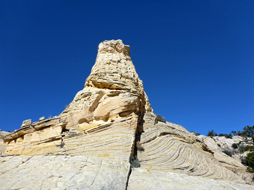
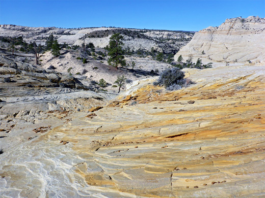
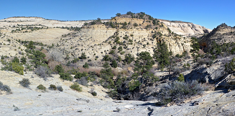
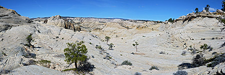
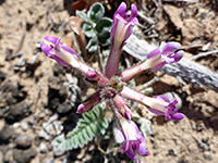
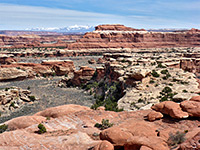
The stream is followed south a short distance, initially at creek level, later on a bench just above, where the path is lined by dozens of purple-blooming astagalus mollissimus flowers in the spring. The trail leaves the valley to the west, up a not-so-steep rocky slope and on to sandier terrain with a few trees, a little way above a broad gully, after which is another climb over slickrock, where the old cable line is first glimpsed; in some places lying on the ground, in others still suspended on trees, all now dead. Nearby are a few photogenic, thin-layered formations. Some more climbing takes the route back into flat, partly-wooded terrain, part of Slickrock Saddle Bench, where level, firm sand provides a good walking surface.
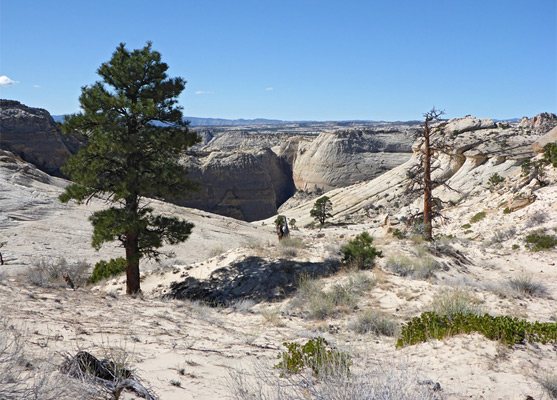
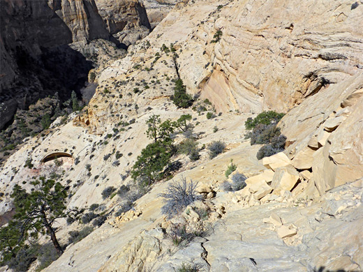
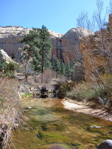
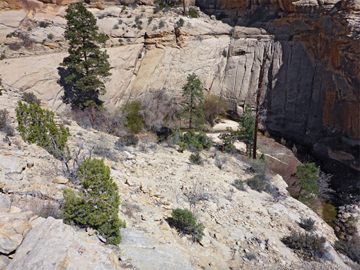
On the far side of the bench, the path moves down a little to a short, intermediate plateau, covered by softer, lighter-colored sand, still following the cable line, then comes out of the woodland to the edge of another vast slickrock expanse, with the much deeper canyon of Death Hollow visible ahead. The stream flows out-of-sight below massive cliffs and domes, all surrounded by numerous other peaks and ravines, in all directions. The sandstone is mostly yellow and pale brown in color, or whitish, so on a sunny day the scenery is particularly bright and crisp. The path descends 150 feet, traverses northwards beneath a ridge then drops down much more steeply by another 600 feet, all the way to the creek, here flowing along the west side of the canyon, the east side containing a band of bushes and reeds. This point, on the floor of Death Hollow, is 5.6 miles from the Boulder trailhead and 8.9 miles from Escalante.
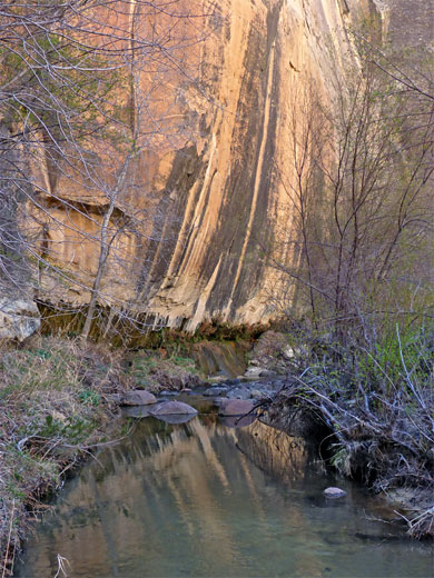
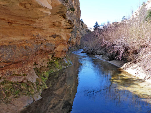
For 0.8 miles the now well-marked trail parallels the creek downstream, crossing it three times. For much of the year the water is just a few inches deep, and stepping stones mean there is usually no need for wading. The canyon winds through three tight bends followed by a grassy straight and then a few more, lesser bends; a sandy patch on the inside of one of these is the start point for the exit path. The stream is bordered by sheer cliffs in a few places and narrow, sandy beaches in others, but mostly by undergrowth on both sides. Willow and cattail are amongst the most abundant plants.
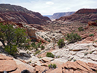
The western ascent from Death Hollow is steep initially, to a bench, and then moderate, crossing bare, rocky slopes up to a ledgy area with a few hoodoos and outcrops of jagged, dark red sandstone. The land along the uppermost section of the climb becomes sandy, and partly wooded, and the old cable line is visible once more. The wide shallow canyon of the next drainage (Mamie Creek) starts to come in to view, and is reached by a relatively quick descent, briefly steep but otherwise straightforward. The crossing of Mamie Creek is 8.3 miles from the Boulder trailhead, and is usually dry since the stream flows only during wet weather, though it does contain many residual, long lasting pools of brownish water, some large; one just downstream of the crossing is nearly 100 feet across. The path runs alongside the creek for a short distance then starts a gradual climb southeast, later southwest, over a few ridges and down to a smaller, unnamed drainage. The final few miles alternate between grassy, bushy flats, patches of slickrock, and other small washes, until the trail descends 400 feet down a cliff to Pine Creek, a major north-side Escalante River tributary. The confluence with the river is 0.8 miles south, and the Escalante trailhead is a short distance further.
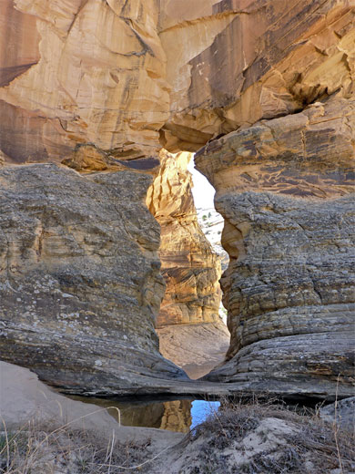
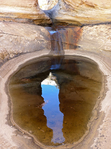
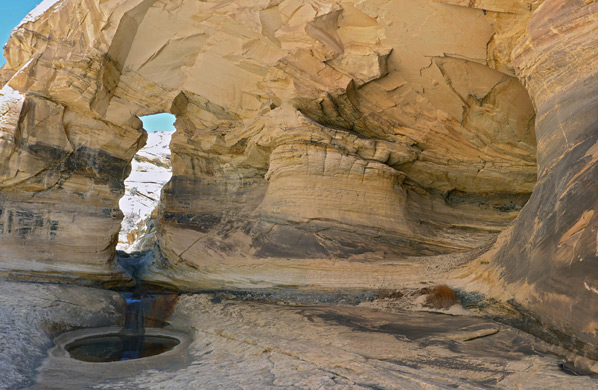
Mamie Creek Natural Bridge is reached by walking down the streambed for 0.8 miles from the trail crossing; past the big pool, soon after which are two more of similar size, then along a straighter section, where the canyon floor is mostly formed of thin, colorful, angled strata. Several minor bends are followed by a few little falls and circular potholes, as the drainage crosses rocks that are somewhat darker in color. Next is another, longer straight section, where the floor is variously rock, sand or pebbles, and the canyon becomes more cliff-bound. The bridge appears just after a sharp bend south; beyond is a party enclosed chamber with a pool just below the opening, and then a big pour-off leading to the wider, lower section of the drainage. On sunny days the bridge itself is mostly in shadow, while the surrounding light-colored rocks are fully illuminated, so it is not always easy to photograph effectively. Footprints along the wash suggest the bridge to be a relatively popular destination. The pour-off cannot be descended directly, but the enclosed lower part of the Mamie Creek drainage, which contains more falls and pools, may be reached by a short bypass on the west side.
The distance between the two trailheads is 14.5 miles, so the hike could be completed in one day with a vehicle shuttle, and a commercial shuttle service is available in Escalante. The usual practice is to leave a car in Escalante, take the shuttle or drive another vehicle to the Boulder trailhead and hike back, since this direction involves less elevation gain. The east end of the path is 1,140 feet higher than the west end, while the cumulative elevation change along the whole route is about 4,500 feet (1,700 feet up, 2,800 feet down), owing to several steep climbs in and out of drainages.
Once past the Escalante River and the tributary of Pine Creek, the westernmost few miles are not so interesting, crossing generally low relief land and small washes, so the eastern trailhead is also the preferred start point for shorter, there-and-back hikes, and the most popular destination is Death Hollow, reached after 5.6 miles. This is the largest drainage along the trail, and contains a year-round stream flowing through a dramatic canyon up to 900 feet deep, between vertical cliffs of whitish Navajo sandstone, the same rock exposed along most of the trail; only at the highest elevations is the overlying Carmel Formation visible.
If water levels are not too high, Death Hollow can be followed up or down stream, potentially all the way to Hell's Backbone Road in the north or the Escalante River in the south, and together with several other drainages, principally Sand Creek and Mamie Creek, the Mail Trail can form part of various multi-day, backpacking loops. The trail itself is obvious in some places - through vegetated areas, along the floor of Death Hollow (for 0.8 miles), and in and out of other canyons, but is less apparent where it crosses large areas of slickrock. All the route is marked by cairns, but some are quite far apart.
Route Summary
From the east, the trail passes through flattish, wooded land to the edge of a plateau, descends across slickrock to the permanent drainage of Sand Creek (2.5 miles), traverses a partly sandy ridge, then descends again, much more steeply, into Death Hollow. On the far side, a steep climb leads up and over another wooded flat and down to the lesser drainage of Mamie Creek (8.3 miles). The next 4 miles are over more gently undulating land including several smaller ravines, before a short but steep descent to Pine Creek, from where the Escalante River and the western end of the path are not far ahead. Amongst many possible side trips is to Mamie Creek Natural Bridge, 0.8 miles downstream of the trail crossing - this unusual feature has formed where the (seasonal) creek has eroded a keyhole-shaped opening through a protruding fin, on the brink of a dryfall.
Boulder Mail Trailheads
The Escalante trailhead is at the end of a 0.9 mile track which forks off Hwy 12 on the east side of town, near the local high school and the cemetery; from here, the path heads north, approaching the Escalante River in a quarter of a mile. The eastern trailhead is reached by driving 650 feet along Hells Backbone Road, which leaves the highway 3 miles west of Boulder, then half a mile south on a narrower track that crosses the national monument boundary, soon followed by Boulder Airstrip, and ends at a clearing surrounded by small trees. This track is stony and rutted in parts, so large vehicles may have to be parked along Hells Backbone Road. Free, primitive camping is allowed anywhere hereabouts, except in the vicinity of the airstrip.
The First Two Miles
The Boulder trailhead has a register and several informative notices. The original course of the Boulder Mail route is south, along a fainter continuation of the approach track, but the first mile or so of the trail takes a different course, first heading west for a short distance then southwest, through sparse forest, over land covered with blackish basalt boulders, all the while descending gently. The path runs along a little wash for a while, leaving it just before a minor pour-off, then traverses a sagebrush flat, and returns to wooded land, as the ground becomes more sandy. After a preliminary descent, down a low cliff and across a sandy basin, the path reaches the rim of the plateau, where the forest stops abruptly and ground falls away steeply to the west. For the remaining 12.5 miles to Escalante, the majority of land is bare slopes and domes of Navajo sandstone, interrupted by just a few short, sandy, wooded patches, at the higher elevations.
Sand Creek
The trail descends a curving slope, passing some small, eroded formations, and moves west into a wide, shallow drainage with a few sandy potholes, that leads to Sand Creek. Amongst the predominantly white rocks are a few more colorful areas, of yellow and brown, and some thin-layered patches crossed with parallel red or pink lines. Bright, red-flowered Indian paintbrush grows in crevices, making a striking contrast to the lighter-colored bedrock. Sand Creek is narrow and fast-moving, flowing through a narrow corridor of bushes and trees but otherwise not overgrown, along a canyon that is relatively shallow, enclosed by slopes rather than cliffs.
Slickrock Saddle Bench
The stream is followed south a short distance, initially at creek level, later on a bench just above, where the path is lined by dozens of purple-blooming astagalus mollissimus flowers in the spring. The trail leaves the valley to the west, up a not-so-steep rocky slope and on to sandier terrain with a few trees, a little way above a broad gully, after which is another climb over slickrock, where the old cable line is first glimpsed; in some places lying on the ground, in others still suspended on trees, all now dead. Nearby are a few photogenic, thin-layered formations. Some more climbing takes the route back into flat, partly-wooded terrain, part of Slickrock Saddle Bench, where level, firm sand provides a good walking surface.
Death Hollow
On the far side of the bench, the path moves down a little to a short, intermediate plateau, covered by softer, lighter-colored sand, still following the cable line, then comes out of the woodland to the edge of another vast slickrock expanse, with the much deeper canyon of Death Hollow visible ahead. The stream flows out-of-sight below massive cliffs and domes, all surrounded by numerous other peaks and ravines, in all directions. The sandstone is mostly yellow and pale brown in color, or whitish, so on a sunny day the scenery is particularly bright and crisp. The path descends 150 feet, traverses northwards beneath a ridge then drops down much more steeply by another 600 feet, all the way to the creek, here flowing along the west side of the canyon, the east side containing a band of bushes and reeds. This point, on the floor of Death Hollow, is 5.6 miles from the Boulder trailhead and 8.9 miles from Escalante.
Along the Stream
For 0.8 miles the now well-marked trail parallels the creek downstream, crossing it three times. For much of the year the water is just a few inches deep, and stepping stones mean there is usually no need for wading. The canyon winds through three tight bends followed by a grassy straight and then a few more, lesser bends; a sandy patch on the inside of one of these is the start point for the exit path. The stream is bordered by sheer cliffs in a few places and narrow, sandy beaches in others, but mostly by undergrowth on both sides. Willow and cattail are amongst the most abundant plants.
Mamie Creek, and the West End of the Trail
The western ascent from Death Hollow is steep initially, to a bench, and then moderate, crossing bare, rocky slopes up to a ledgy area with a few hoodoos and outcrops of jagged, dark red sandstone. The land along the uppermost section of the climb becomes sandy, and partly wooded, and the old cable line is visible once more. The wide shallow canyon of the next drainage (Mamie Creek) starts to come in to view, and is reached by a relatively quick descent, briefly steep but otherwise straightforward. The crossing of Mamie Creek is 8.3 miles from the Boulder trailhead, and is usually dry since the stream flows only during wet weather, though it does contain many residual, long lasting pools of brownish water, some large; one just downstream of the crossing is nearly 100 feet across. The path runs alongside the creek for a short distance then starts a gradual climb southeast, later southwest, over a few ridges and down to a smaller, unnamed drainage. The final few miles alternate between grassy, bushy flats, patches of slickrock, and other small washes, until the trail descends 400 feet down a cliff to Pine Creek, a major north-side Escalante River tributary. The confluence with the river is 0.8 miles south, and the Escalante trailhead is a short distance further.
Mamie Creek Natural Bridge
Mamie Creek Natural Bridge is reached by walking down the streambed for 0.8 miles from the trail crossing; past the big pool, soon after which are two more of similar size, then along a straighter section, where the canyon floor is mostly formed of thin, colorful, angled strata. Several minor bends are followed by a few little falls and circular potholes, as the drainage crosses rocks that are somewhat darker in color. Next is another, longer straight section, where the floor is variously rock, sand or pebbles, and the canyon becomes more cliff-bound. The bridge appears just after a sharp bend south; beyond is a party enclosed chamber with a pool just below the opening, and then a big pour-off leading to the wider, lower section of the drainage. On sunny days the bridge itself is mostly in shadow, while the surrounding light-colored rocks are fully illuminated, so it is not always easy to photograph effectively. Footprints along the wash suggest the bridge to be a relatively popular destination. The pour-off cannot be descended directly, but the enclosed lower part of the Mamie Creek drainage, which contains more falls and pools, may be reached by a short bypass on the west side.
Boulder Mail Trail - Similar Hikes
All Contents © Copyright The American Southwest | Comments and Questions | Contribute | Affiliate Marketing Disclosure | Site Map