The Gulch, Grand Staircase-Escalante National Monument
Utah > Grand Staircase-Escalante National Monument > The Gulch
The Gulch
Lengthy tributary of the Escalante River, crossed by the Burr Trail; the downstream section is the most popular for hiking, providing generally easy walking along a relatively wide and scenic canyon. Two major side-ravines, King Bench Canyon and Halfway Hollow, contain short sections of narrows. The hike described here is down the Gulch for 5 miles, returning up the first of these tributaries
Length: 10 miles, round trip
Elevation change: 650 feet
Difficulty: Moderate
Type: Loop, partly cross-country
Usage: Low
Season: Fall, winter, spring - hot in summer
Trailhead: Along the Burr Trail
Rating (1-5): ★★★★★
Elevation change: 650 feet
Difficulty: Moderate
Type: Loop, partly cross-country
Usage: Low
Season: Fall, winter, spring - hot in summer
Trailhead: Along the Burr Trail
Rating (1-5): ★★★★★

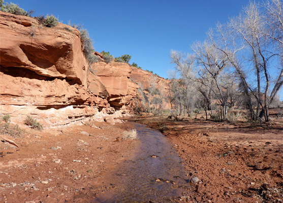
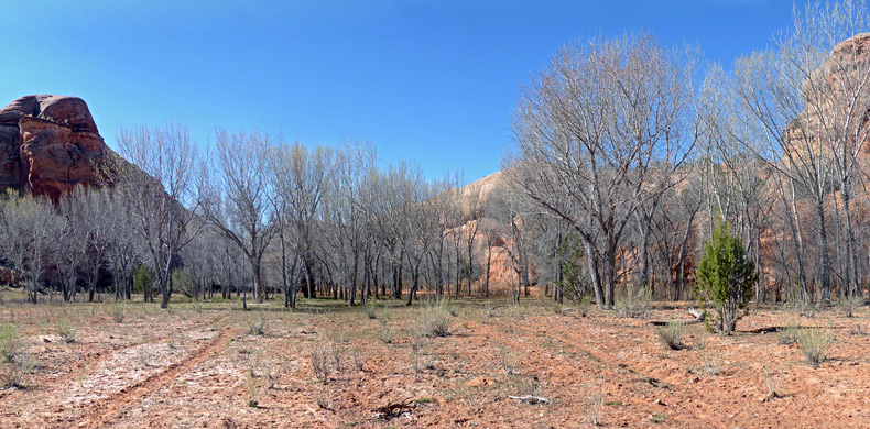
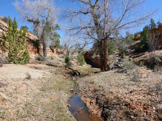
The Gulch is a major tributary of the Escalante River in the northeast corner of Grand Staircase-Escalante National Monument, and it provides generally easy hiking along what is for most of the way a relatively wide canyon, where a small but near-permanent stream flows along a flat, partly wooded valley floor that is up to 700 feet wide, and enclosed by low, reddish cliffs of Wingate sandstone. The Gulch is crossed by the paved Burr Trail towards its upper end, and is served by a BLM-maintained trailhead; the ease of access, and pretty, if not always so spectacular scenery, make this one of the more popular canyon hikes in the national monument, though the route is still quiet compared to the average NPS trail.
The gulch extends for some ten miles upstream of the road crossing, and this section contains a few pools, cascades and brief narrows, but it quite soon becomes rather wide, and dryer, so this part is not visited so often; instead, most people head downstream. Backpackers can walk for 12 miles and reach the Escalante River, perhaps returning up the nearby drainage of Deer Creek, or along the river itself, while for day visitors there are several targets for shorter hikes including the first major tributary (King Bench Canyon) after 5 miles, or the second, Halfway Hollow, after 8.5 miles, this just downstream of a one mile section where the canyon is much narrower, though still not particularly deep.
Both these side drainages contain short slots, and either can be used as a return route, to make a loop hike of 10 or 19 miles respectively; the first of these is described below. The initial five mile section of the Gulch is classed as an Outstanding Natural Area, a designation that recognizes places which have nationally important scenic values.
Topographic map of the Gulch; overview map of Grand Staircase-Escalante NM.
28 views of the Gulch.
The Burr Trail crosses the Gulch ten miles east of Boulder; the road drops quite steeply down a cliff face on the west side of the canyon, then continues northwards along the valley floor. The designated trailhead is at the end of a very short (450 foot), rather bumpy track into a little side canyon, though parking might be easier on grass verges quarter of a mile further, and here another side track leads to a sandy area beneath a big cottonwood tree, a possible camping location. Primitive camping is also available about a mile back, on top of the cliffs, along sandy tracks just north of the road.
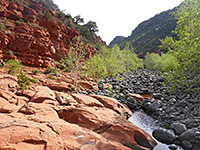
From the official trailhead, a hiker-made path leads up the overgrown side canyon for 800 feet, bearing south into a cliff-lined basin, and ending beneath a small Anasazi ruin. The main route is downstream; a well-used trail heads southeast, past a BLM register and through a gate in a fence marking the boundary of the King Bench Ranch - all this section of the canyon is much frequented by cattle, whose presence tends to detract somewhat from the hiking experience. The Gulch at this point is enclosed by vertical cliffs or steep, boulder-covered slopes, up to 300 feet high, while the canyon floor is wide, mostly sandy or grassy, with groves of cottonwood trees close to the streambed. The creek is generally just a few inches deep and maybe three feet wide, and the ground alongside is often trampled by the cattle. The scenery is similar for the first 7.5 miles, until the canyon constricts as it approaches Halfway Hollow, forming some watery narrows. The trees remain leafless well into April, owing to the relatively high elevation, and the partial shade of the canyon walls.
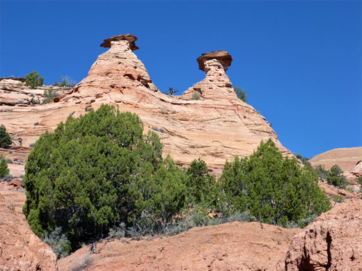
The trail climbs a sandy bench to cut off the first bend and thereafter crosses the stream periodically, running sometimes through the shady trees, in other places over open flats. A small tributary joins from east after half a mile, followed by a longish straight, and then another side canyon after 1.2 miles. A sheer-sided butte rises on the east side (1.9 miles), after which the path crosses a lengthy sandy area, passing beneath two conical hoodoos, then rounds a minor bend and enters another long straight. After 2.8 miles, a small metal hut comes into view - known as Kelly's Cabin, this receives semi-regular use by ranchers - inside are a bed, table, shelves and supplies, while outside are several aged relics including a bedframe and rusty cans.
The enclosing cliffs become a little higher, topped by whitish domes of Navajo sandstone. The ravine twists and turns through several tighter bends, then curves due east at 4.6 miles, as a hidden tributary joins from the west, containing a spring 600 feet upstream. The main drainage resumes its southwards course after five miles, at the confluence with a larger tributary on the north side - this is unnamed on topographic maps but can be referred to as King Bench Canyon, after the high ground from where the drainage originates. The lower end contains a shallow stream, or isolated pools, though becomes mostly dry at hotter times of the year. At first the canyon is moderately overgrown, with bushes and big cottonwoods, and is lined by low cliffs, undercut by the stream in some places.
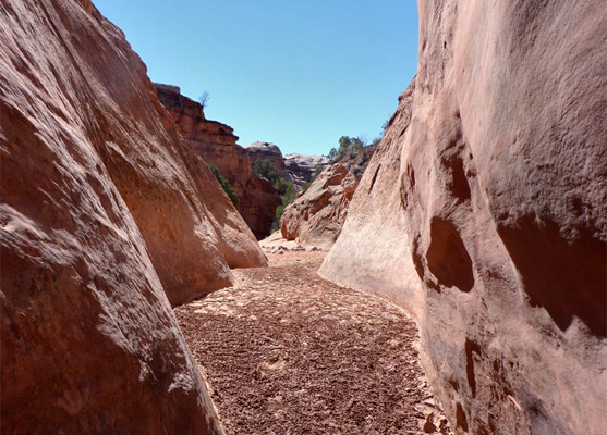
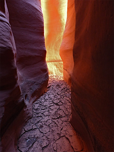
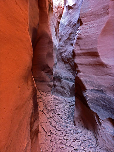
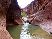
After a larger pool below a little drop, the ravine becomes drier and more open, containing less vegetation. Taller cliffs rise on both sides, after a section with slopes and benches that allow exit to the plateau above. A shallow slot forms quite soon, ending below a drop formed by chokestones and logs, then after a brief open, rocky section still with virtually no vegetation, a better, deeper slot begins; this has a few minor upclimbs and plenty of tight curves, becoming properly enclosed and ending in a round chamber below a bigger drop, not easily climbable. The slot can be bypassed on the east side; back about a quarter of a mile, up a minor gully to the base of a group of white domes then north along sandy benches, gradually coming back down to the streambed, which soon enters a shallower slot, free of obstructions.
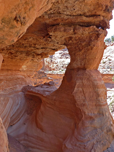
The canyon sides are now sloping rather than sheer, though still with many patches of rock eroded into unusual forms, including occasional arches. The last of several shallow slots ends after 2 miles, just beyond which is a short tributary on the west side, providing a start for the cross-country route back to the Gulch. The terrain hereabouts is easy to navigate; the quickest route back is northwest for about a mile, then a descent into the upper end of the second major east side tributary, which leads to the floor of the main canyon, 1.2 miles south of the trailhead.
The gulch extends for some ten miles upstream of the road crossing, and this section contains a few pools, cascades and brief narrows, but it quite soon becomes rather wide, and dryer, so this part is not visited so often; instead, most people head downstream. Backpackers can walk for 12 miles and reach the Escalante River, perhaps returning up the nearby drainage of Deer Creek, or along the river itself, while for day visitors there are several targets for shorter hikes including the first major tributary (King Bench Canyon) after 5 miles, or the second, Halfway Hollow, after 8.5 miles, this just downstream of a one mile section where the canyon is much narrower, though still not particularly deep.
Both these side drainages contain short slots, and either can be used as a return route, to make a loop hike of 10 or 19 miles respectively; the first of these is described below. The initial five mile section of the Gulch is classed as an Outstanding Natural Area, a designation that recognizes places which have nationally important scenic values.

Location
Topographic map of the Gulch; overview map of Grand Staircase-Escalante NM.
Photographs
28 views of the Gulch.
The Gulch Trailhead
The Burr Trail crosses the Gulch ten miles east of Boulder; the road drops quite steeply down a cliff face on the west side of the canyon, then continues northwards along the valley floor. The designated trailhead is at the end of a very short (450 foot), rather bumpy track into a little side canyon, though parking might be easier on grass verges quarter of a mile further, and here another side track leads to a sandy area beneath a big cottonwood tree, a possible camping location. Primitive camping is also available about a mile back, on top of the cliffs, along sandy tracks just north of the road.
The Canyon
From the official trailhead, a hiker-made path leads up the overgrown side canyon for 800 feet, bearing south into a cliff-lined basin, and ending beneath a small Anasazi ruin. The main route is downstream; a well-used trail heads southeast, past a BLM register and through a gate in a fence marking the boundary of the King Bench Ranch - all this section of the canyon is much frequented by cattle, whose presence tends to detract somewhat from the hiking experience. The Gulch at this point is enclosed by vertical cliffs or steep, boulder-covered slopes, up to 300 feet high, while the canyon floor is wide, mostly sandy or grassy, with groves of cottonwood trees close to the streambed. The creek is generally just a few inches deep and maybe three feet wide, and the ground alongside is often trampled by the cattle. The scenery is similar for the first 7.5 miles, until the canyon constricts as it approaches Halfway Hollow, forming some watery narrows. The trees remain leafless well into April, owing to the relatively high elevation, and the partial shade of the canyon walls.

Kelly's Cabin
The trail climbs a sandy bench to cut off the first bend and thereafter crosses the stream periodically, running sometimes through the shady trees, in other places over open flats. A small tributary joins from east after half a mile, followed by a longish straight, and then another side canyon after 1.2 miles. A sheer-sided butte rises on the east side (1.9 miles), after which the path crosses a lengthy sandy area, passing beneath two conical hoodoos, then rounds a minor bend and enters another long straight. After 2.8 miles, a small metal hut comes into view - known as Kelly's Cabin, this receives semi-regular use by ranchers - inside are a bed, table, shelves and supplies, while outside are several aged relics including a bedframe and rusty cans.
King Bench Canyon
The enclosing cliffs become a little higher, topped by whitish domes of Navajo sandstone. The ravine twists and turns through several tighter bends, then curves due east at 4.6 miles, as a hidden tributary joins from the west, containing a spring 600 feet upstream. The main drainage resumes its southwards course after five miles, at the confluence with a larger tributary on the north side - this is unnamed on topographic maps but can be referred to as King Bench Canyon, after the high ground from where the drainage originates. The lower end contains a shallow stream, or isolated pools, though becomes mostly dry at hotter times of the year. At first the canyon is moderately overgrown, with bushes and big cottonwoods, and is lined by low cliffs, undercut by the stream in some places.
Slot Canyons
After a larger pool below a little drop, the ravine becomes drier and more open, containing less vegetation. Taller cliffs rise on both sides, after a section with slopes and benches that allow exit to the plateau above. A shallow slot forms quite soon, ending below a drop formed by chokestones and logs, then after a brief open, rocky section still with virtually no vegetation, a better, deeper slot begins; this has a few minor upclimbs and plenty of tight curves, becoming properly enclosed and ending in a round chamber below a bigger drop, not easily climbable. The slot can be bypassed on the east side; back about a quarter of a mile, up a minor gully to the base of a group of white domes then north along sandy benches, gradually coming back down to the streambed, which soon enters a shallower slot, free of obstructions.
Return to the Gulch
The canyon sides are now sloping rather than sheer, though still with many patches of rock eroded into unusual forms, including occasional arches. The last of several shallow slots ends after 2 miles, just beyond which is a short tributary on the west side, providing a start for the cross-country route back to the Gulch. The terrain hereabouts is easy to navigate; the quickest route back is northwest for about a mile, then a descent into the upper end of the second major east side tributary, which leads to the floor of the main canyon, 1.2 miles south of the trailhead.

The Gulch - Similar Hikes
All Contents © Copyright The American Southwest | Comments and Questions | Contribute | Affiliate Marketing Disclosure | Site Map