Hidden Canyon
Narrow, V-shaped ravine containing a few short enclosed sections and dryfalls. The lower part is accessed by a maintained trail; more can be seen by hiking and scrambling upstream. Currently inaccessible
Length: 1.1 miles to the end of the path; up to 2 miles if hiking further up the canyon
Difficulty: Easy to moderate; several short climbs beyond the official path, which en route traverses a steep cliff with the aid of chains
Management: NPS - within Zion National Park
Rocks: Navajo sandstone
Season: Spring, summer, fall
Trailhead: Weeping Rock - Zion Canyon shuttle stop 6
Rating (1-5): ★★★★★

Hidden Canyon has been inaccessible since a major rockfall in 2019; as of 2025 there is still no news on any reopening.
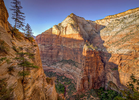
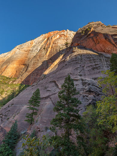
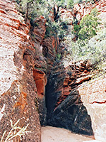
Hidden Canyon is one of the many scenic side ravines that join the Virgin River - although not a true slot canyon, all is deep and narrow, with several parts that contain boulders, dryfalls and enclosed channels. The one mile trail leading to it combines aspects of the two nearby routes to the Narrows and Angel's Landing. It starts at Weeping Rock, one of the more easily accessible and often visited landmarks in Zion National Park, where water seeps from between two rock strata forming an elongated mini waterfall, with attractive curtains of green vegetation and colorful wildflowers in the spring. From here the route switchbacks 600 feet up the side of Zion Canyon, crosses the cliffs for a way then enters the mouth of the ravine, where the conditions change abruptly, becoming cool, shady and enclosed.
Hidden Canyon is reached via the East Rim Trail, beginning at a former parking area 2 miles from the north end of the Zion Canyon Scenic Drive, and reached from stop number 6 of the Zion shuttlebus - the same starting point for a visit to Weeping Rock.
No special permit is required, just a standard Zion National Park entry fee.
The path climbs steeply at first with several switchbacks before becoming more level, crossing the cliff face. At this point, the trail divides; the main branch follows Echo Canyon for a while and then climbs to the top of the cliffs, linking with the route to Observation Point.
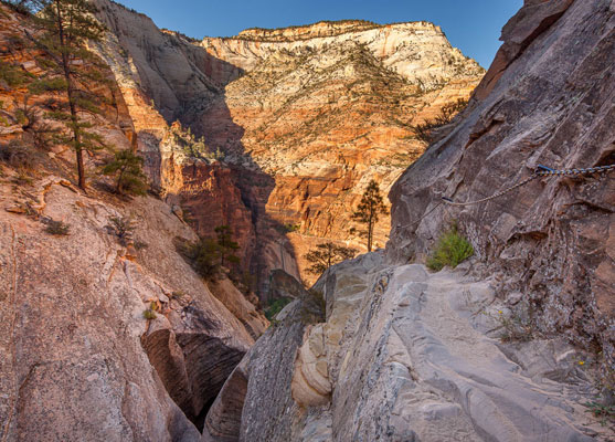
The Hidden Canyon branch of the trail climbs a little more after the Echo Canyon junction, winds around a small side-valley and traverses a steep cliff face. For the last few hundred yards the path is cut into the side of the cliff and has a sheer drop of several hundred feet at one side. As with the latter stages of the route to Angels Landing, chains are provided in places to help the unsure, and on a busy summers day there might be quite a delay here, due to slow-moving people.
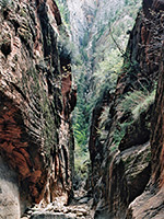
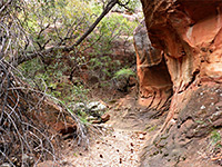
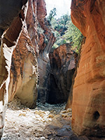
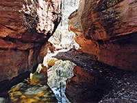
The marked trail ends one third of the way up the main cliffs at the mouth of Hidden Canyon, which is dry for most of the year. However, it is possible to walk and climb further up this canyon for about one mile, before the first of several high dryfalls that make the canyon only fully traversable in the downstream direction, starting from the plateau above (accessed via the Deertrap Mountain Trail). The route has some similarities to the Zion Narrows trail, but without water, and there are several small cliffs and chokestones that require the use of tree branches as improvised ladders. The journey becomes more taxing further upstream, with several steep, narrow sections and larger boulders.
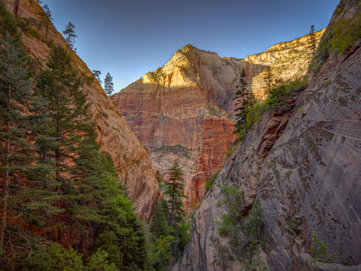
The canyon is cool and sheltered, and makes an ideal hike for hot summer days as the sun rarely reaches the floor. Although rather strenuous, the experience can be very peaceful, as few people come very far along the gorge. This is partly because the first major obstacle - a 7 foot high cliff - occurs quite close to the beginning.
Hidden Canyon is one of the many scenic side ravines that join the Virgin River - although not a true slot canyon, all is deep and narrow, with several parts that contain boulders, dryfalls and enclosed channels. The one mile trail leading to it combines aspects of the two nearby routes to the Narrows and Angel's Landing. It starts at Weeping Rock, one of the more easily accessible and often visited landmarks in Zion National Park, where water seeps from between two rock strata forming an elongated mini waterfall, with attractive curtains of green vegetation and colorful wildflowers in the spring. From here the route switchbacks 600 feet up the side of Zion Canyon, crosses the cliffs for a way then enters the mouth of the ravine, where the conditions change abruptly, becoming cool, shady and enclosed.
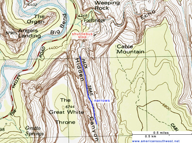
Topographic Map of Hidden Canyon
Location
Hidden Canyon is reached via the East Rim Trail, beginning at a former parking area 2 miles from the north end of the Zion Canyon Scenic Drive, and reached from stop number 6 of the Zion shuttlebus - the same starting point for a visit to Weeping Rock.
Permit
No special permit is required, just a standard Zion National Park entry fee.
Route Description
The path climbs steeply at first with several switchbacks before becoming more level, crossing the cliff face. At this point, the trail divides; the main branch follows Echo Canyon for a while and then climbs to the top of the cliffs, linking with the route to Observation Point.
The Hidden Canyon branch of the trail climbs a little more after the Echo Canyon junction, winds around a small side-valley and traverses a steep cliff face. For the last few hundred yards the path is cut into the side of the cliff and has a sheer drop of several hundred feet at one side. As with the latter stages of the route to Angels Landing, chains are provided in places to help the unsure, and on a busy summers day there might be quite a delay here, due to slow-moving people.
End of the Trail
The marked trail ends one third of the way up the main cliffs at the mouth of Hidden Canyon, which is dry for most of the year. However, it is possible to walk and climb further up this canyon for about one mile, before the first of several high dryfalls that make the canyon only fully traversable in the downstream direction, starting from the plateau above (accessed via the Deertrap Mountain Trail). The route has some similarities to the Zion Narrows trail, but without water, and there are several small cliffs and chokestones that require the use of tree branches as improvised ladders. The journey becomes more taxing further upstream, with several steep, narrow sections and larger boulders.
The canyon is cool and sheltered, and makes an ideal hike for hot summer days as the sun rarely reaches the floor. Although rather strenuous, the experience can be very peaceful, as few people come very far along the gorge. This is partly because the first major obstacle - a 7 foot high cliff - occurs quite close to the beginning.
Hidden Canyon - Similar Hikes
All Contents © Copyright The American Southwest | Comments and Questions | Contribute | Affiliate Marketing Disclosure | Site Map