Alpine Pond Trail, Cedar Breaks National Monument
Utah > Cedar Breaks National Monument > Alpine Pond Trail
Alpine Pond Trail
Loop across a wooded section of the rim, past a scree slope and a shallow pond; many wildflowers in the summer, and occasional views of the red rock formations below

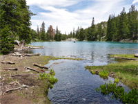
The Alpine Pond Trail is the shorter of the two main hiking paths in Cedar Breaks National Monument (Spectra Point and Ramparts Overlook Trail is the other); a 2.2 mile loop along a mostly wooded section of the rim about halfway along the scenic drive (Hwy 148), centered on a shallow, pretty, tree-lined pond, fed by melting snow and a small spring.
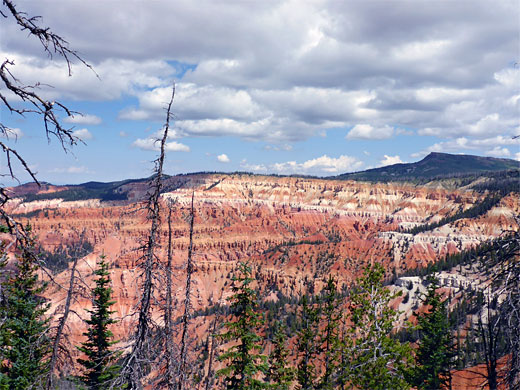
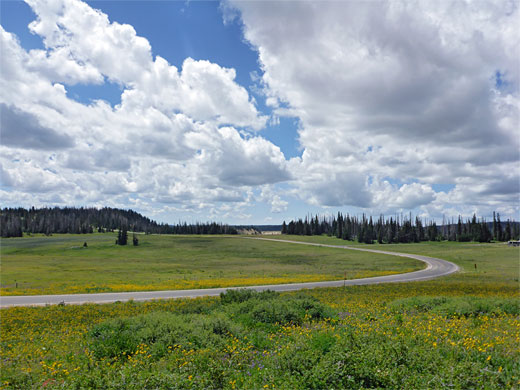
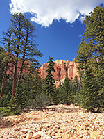
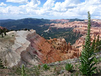
The southern end of the trail runs close to the edge of the plateau and offers fleeting views of the red rock formations below, but most of the loop is out-of-sight of the amphitheater, crossing open pine woodland that also contains patches of wet and dry meadows, and at one point, a steep scree slope. The eastern component of the loop, between 100 and 200 feet higher up, stays close to the edge of the woods, looking out across the wide grassland either side of the park road, with views across to the higher peaks around Brian Head.
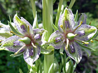
The hike can be accessed from either the north or south, from two trailheads along Hwy 148, and can be shortened via a connecting path half way along, just south of the pond, allowing loops of just over a mile. The varied scenery and gentle gradients make this a popular walk, especially in mid to late summer when wildflowers are at their peak, and several dozen species can be in bloom at the same time.
Map of Cedar Breaks.
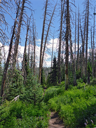
The southern trailhead for the Alpine Pond hike is at the end of the short side road to Chessmen Ridge Overlook, while the northern trailhead is 1.1 miles beyond. From each start point a single path leads a short distance to a junction at the start of the loop section (1.9 miles). The southern route starts by following the rim a short distance to the junction, after which the left branch (the Lower Trail) stays close to the plateau edge, through moist aspen and spruce woodland where the many wildflowers include bluebell, larkspur and columbine. A short flight of steps takes the trail up to a good viewpoint of the formations below, after which it enters a little ravine and turns away from the rim, traversing a region burnt in a recent wildfire, leaving most of the old-growth trees dead. The ground rises as the trail follows a tiny stream, past the connection with the upper section of the loop, to its source on the south side of the alpine pond.
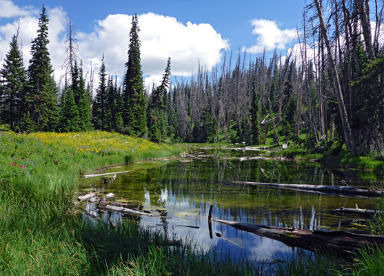
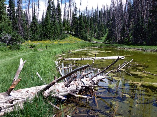
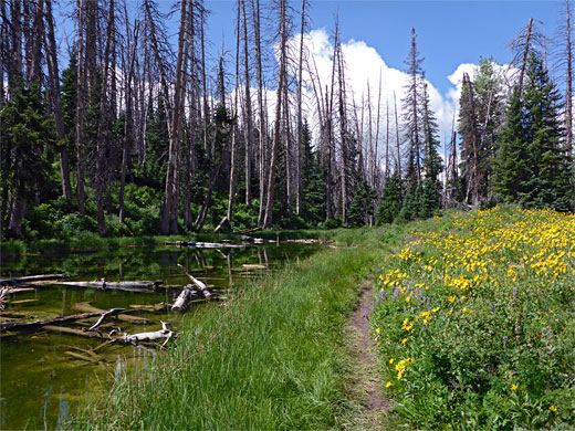
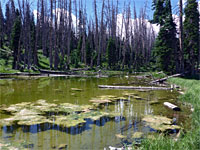
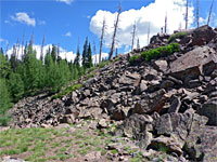
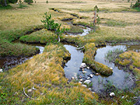
The pond is 300 feet long, quite narrow, bordered on the east side by a steep forested slope but open and sunny to the west, allowing a great profusion of wildflowers to grow. After following the shoreline and crossing a boggy area half way along, the path continues through patches of trees interspersed with dry grassland, supporting a different selection of flowers from the moister areas to the south, then runs beneath the scree slope, which harbors a small population of marmots, and climbs briefly to the junction at the north end of the loop, from where the northern trailhead is 400 feet away.
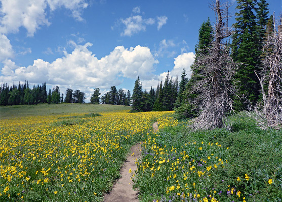
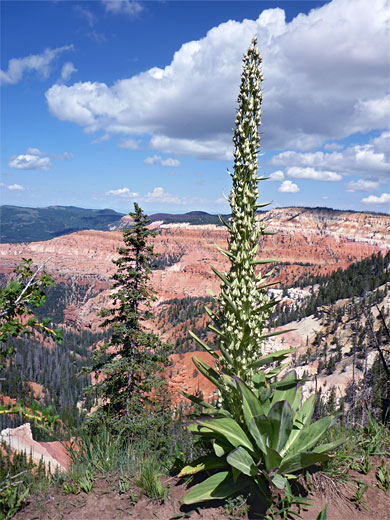
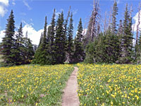
The eastern section of the loop, the Upper Trail, runs south along the top of the scree slope and on through flat, shady woodland, winding between many large trees, later passing the steeply descending link path near the pond, which is somewhat obscured by the trees. The tall pines persist a little way further, before the path leaves the woodland and follows close to the edge of the broad meadow beside the road, and on to the junction with path from Chessmen Ridge Overlook. In summer the meadow is filled with thousands of yellow-flowered arnica, mixed with the tall spikes of the monument plant.
The southern end of the trail runs close to the edge of the plateau and offers fleeting views of the red rock formations below, but most of the loop is out-of-sight of the amphitheater, crossing open pine woodland that also contains patches of wet and dry meadows, and at one point, a steep scree slope. The eastern component of the loop, between 100 and 200 feet higher up, stays close to the edge of the woods, looking out across the wide grassland either side of the park road, with views across to the higher peaks around Brian Head.
The hike can be accessed from either the north or south, from two trailheads along Hwy 148, and can be shortened via a connecting path half way along, just south of the pond, allowing loops of just over a mile. The varied scenery and gentle gradients make this a popular walk, especially in mid to late summer when wildflowers are at their peak, and several dozen species can be in bloom at the same time.
Location
Map of Cedar Breaks.
The Lower Trail
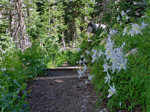
The southern trailhead for the Alpine Pond hike is at the end of the short side road to Chessmen Ridge Overlook, while the northern trailhead is 1.1 miles beyond. From each start point a single path leads a short distance to a junction at the start of the loop section (1.9 miles). The southern route starts by following the rim a short distance to the junction, after which the left branch (the Lower Trail) stays close to the plateau edge, through moist aspen and spruce woodland where the many wildflowers include bluebell, larkspur and columbine. A short flight of steps takes the trail up to a good viewpoint of the formations below, after which it enters a little ravine and turns away from the rim, traversing a region burnt in a recent wildfire, leaving most of the old-growth trees dead. The ground rises as the trail follows a tiny stream, past the connection with the upper section of the loop, to its source on the south side of the alpine pond.
The Alpine Pond
The pond is 300 feet long, quite narrow, bordered on the east side by a steep forested slope but open and sunny to the west, allowing a great profusion of wildflowers to grow. After following the shoreline and crossing a boggy area half way along, the path continues through patches of trees interspersed with dry grassland, supporting a different selection of flowers from the moister areas to the south, then runs beneath the scree slope, which harbors a small population of marmots, and climbs briefly to the junction at the north end of the loop, from where the northern trailhead is 400 feet away.
The Upper Trail
The eastern section of the loop, the Upper Trail, runs south along the top of the scree slope and on through flat, shady woodland, winding between many large trees, later passing the steeply descending link path near the pond, which is somewhat obscured by the trees. The tall pines persist a little way further, before the path leaves the woodland and follows close to the edge of the broad meadow beside the road, and on to the junction with path from Chessmen Ridge Overlook. In summer the meadow is filled with thousands of yellow-flowered arnica, mixed with the tall spikes of the monument plant.
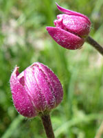
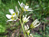
Alpine Pond Wildflowers
More flowers along the trail
 Monument plant |
 Cutleaf anemone |
 Mountain death-camas |
More flowers along the trail
Alpine Pond Trail - Similar Hikes
All Contents © Copyright The American Southwest | Comments and Questions | Contribute | Affiliate Marketing Disclosure | Site Map