Riggs Spring Trail, Bryce Canyon National Park
Utah > Bryce Canyon National Park > Hiking > Riggs Spring Trail
Riggs Spring Trail
Lightly used loop path at the south end of the plateau, mostly across forested slopes below the rim; views of the pink cliffs of Yovimpa Point and the Promontory, and of much lower elevation land to the south. Also passes a spring, one of three backcountry camping locations
Length: 8.5 miles (loop)
Elevation change: 1,650 feet
Difficulty: Moderate; steep in places, and relatively long
Type: Loop
Usage: Low
Season: Late spring, summer, fall
Trailhead: Rainbow Point
Rating (1-5): ★★★★★
Elevation change: 1,650 feet
Difficulty: Moderate; steep in places, and relatively long
Type: Loop
Usage: Low
Season: Late spring, summer, fall
Trailhead: Rainbow Point
Rating (1-5): ★★★★★

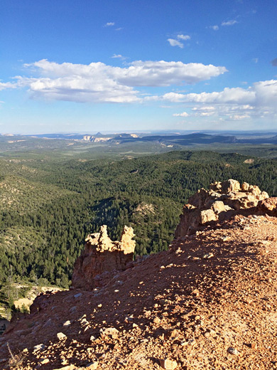
The Riggs Spring Loop Trail is one of the least traveled hiking routes in Bryce Canyon National Park, for several reasons; it is long (8.5 miles), and relatively strenuous owing to the 1,650 feet of elevation gain and loss, it begins right at the farthest point of the scenic drive, and the views are rather limited along much of the path.
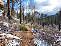
The trail starts at 9,115 foot Rainbow Point, the highest place in the park, crosses forested slopes while descending steadily then for 5 miles moves through fairly level, wooded terrain beneath the Pink Cliffs, which are sporadically visible through gaps in the trees. The lowest section is in the wide valley of Podunk Creek, location of a permanent spring and a primitive campsite, while the return to the plateau is via a steepish climb up a ravine, as the views improve. The final section is above the rim, past Yovimpa Point and back to the trailhead.
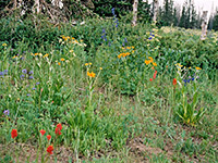
Although short for a two day hike, the trail is one of the main backcountry camping areas in the national park, and has two other designated camp sites: Yovimpa Pass, on the rim, and Corral Hollow, one of four drainages en route. For some people the highlight of the hike is the cool, quiet woodland, which includes a healthy mix of trees and scattered wildflowers, rather than the rock formations, as these are mostly only visible from some distance away.
Two options for continuation hikes are the Under-the-Rim Trail northwards and the Grand View Trail to the east; this latter is a very long route through the adjacent Dixie National Forest. The Riggs Spring Trail was built by the Civilian Conservation Corps in the 1930s, initially to provide access in case of wildfires.
Overview map for Bryce Canyon National Park, Riggs Spring topographic map.
Parking for the hike is at Rainbow Point, 17 miles south of the visitor center, a drive which takes about 40 minutes. This is also the start point for the Bristlecone Trail and a spur to the fine overlook at Yovimpa Point, as well as being the southern terminus of the Under-the-Rim Trail. The route to Riggs Spring can be hiked in either direction, though clockwise seems to be preferred.
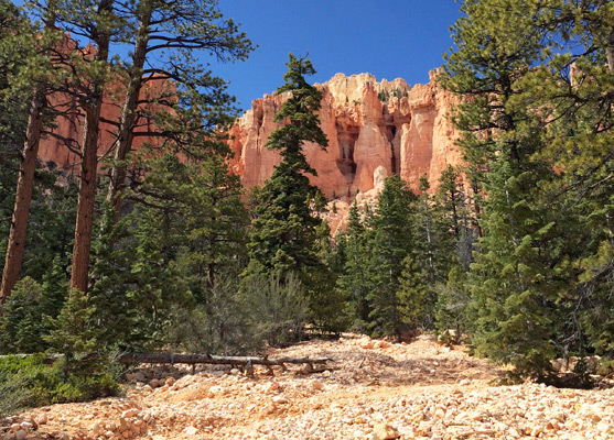
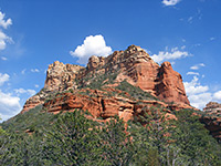
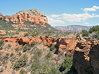
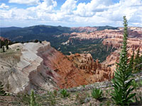
The path starts from the north end of the parking area at Rainbow Point, running along the rim for a short distance, past the first of two junctions with the Bristlecone Trail and quickly on to the second, a four-way intersection, at which the Riggs Spring and Under-the-Rim trails bear left (northeast). This path soon returns to the edge of plateau, and reaches another junction, where the Riggs Spring Trail heads east, into thick and rather dry fir/spruce/aspen forest, below the top of a big ridge known as The Promontory. The opposite, southwest, face is lined by colorful cliffs, but this side has no formations, and the trail descends gradually through the thick trees, giving occasional views of distant white cliffs and canyons to the southeast, around the Paria River drainage.
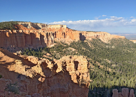
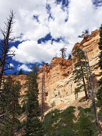
After 1.5 miles, the path approaches the south end of the Promontory, crosses a narrow, protruding ridge a little way above Bullberry Spring and moves back north, now in full view of the Pink Cliffs and Yovimpa Point. For a short time the orange/pink rocks are close by, along the sheer southwest edge of the Promontory, but the views become more restricted as the trail keeps descending through the woodland, which now is mostly composed of ponderosa pines; it eventually drops down into Corral Hollow, location of the first primitive campground. The path crosses a dry, stony streambed, continues west over a saddle into the upper end of a second, unnamed drainage and then across a smaller ridge into a third valley, Mutton Hollow, which is followed southwards to the second campsite at Riggs Spring, where a connecting path leads further south into the Dixie National Forest.
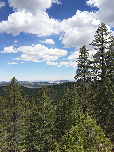
Riggs Spring is the lowest point on the trail (7,460 feet); the hike continues up the larger drainage of Lower Podunk Creek, climbing gently at first then more sharply as the Pink Cliffs come steadily closer once more. The trail ascends to a low point on the rim (Yovimpa Pass) and meets a forest track originating outside the park in the valley of the Sevier River. The third campsite is situated nearby. The final 1.5 miles of the loop is across the plateau, initially away from the rim but returning in two locations, before arriving back in the vicinity of Yovimpa Point, and a final intersection with the Bristlecone Trail.
The trail starts at 9,115 foot Rainbow Point, the highest place in the park, crosses forested slopes while descending steadily then for 5 miles moves through fairly level, wooded terrain beneath the Pink Cliffs, which are sporadically visible through gaps in the trees. The lowest section is in the wide valley of Podunk Creek, location of a permanent spring and a primitive campsite, while the return to the plateau is via a steepish climb up a ravine, as the views improve. The final section is above the rim, past Yovimpa Point and back to the trailhead.
Although short for a two day hike, the trail is one of the main backcountry camping areas in the national park, and has two other designated camp sites: Yovimpa Pass, on the rim, and Corral Hollow, one of four drainages en route. For some people the highlight of the hike is the cool, quiet woodland, which includes a healthy mix of trees and scattered wildflowers, rather than the rock formations, as these are mostly only visible from some distance away.
Two options for continuation hikes are the Under-the-Rim Trail northwards and the Grand View Trail to the east; this latter is a very long route through the adjacent Dixie National Forest. The Riggs Spring Trail was built by the Civilian Conservation Corps in the 1930s, initially to provide access in case of wildfires.
Maps
Overview map for Bryce Canyon National Park, Riggs Spring topographic map.
Trailhead
Parking for the hike is at Rainbow Point, 17 miles south of the visitor center, a drive which takes about 40 minutes. This is also the start point for the Bristlecone Trail and a spur to the fine overlook at Yovimpa Point, as well as being the southern terminus of the Under-the-Rim Trail. The route to Riggs Spring can be hiked in either direction, though clockwise seems to be preferred.
The Promontory
The path starts from the north end of the parking area at Rainbow Point, running along the rim for a short distance, past the first of two junctions with the Bristlecone Trail and quickly on to the second, a four-way intersection, at which the Riggs Spring and Under-the-Rim trails bear left (northeast). This path soon returns to the edge of plateau, and reaches another junction, where the Riggs Spring Trail heads east, into thick and rather dry fir/spruce/aspen forest, below the top of a big ridge known as The Promontory. The opposite, southwest, face is lined by colorful cliffs, but this side has no formations, and the trail descends gradually through the thick trees, giving occasional views of distant white cliffs and canyons to the southeast, around the Paria River drainage.

Forest and Valleys
After 1.5 miles, the path approaches the south end of the Promontory, crosses a narrow, protruding ridge a little way above Bullberry Spring and moves back north, now in full view of the Pink Cliffs and Yovimpa Point. For a short time the orange/pink rocks are close by, along the sheer southwest edge of the Promontory, but the views become more restricted as the trail keeps descending through the woodland, which now is mostly composed of ponderosa pines; it eventually drops down into Corral Hollow, location of the first primitive campground. The path crosses a dry, stony streambed, continues west over a saddle into the upper end of a second, unnamed drainage and then across a smaller ridge into a third valley, Mutton Hollow, which is followed southwards to the second campsite at Riggs Spring, where a connecting path leads further south into the Dixie National Forest.
Return to the Plateau
Riggs Spring is the lowest point on the trail (7,460 feet); the hike continues up the larger drainage of Lower Podunk Creek, climbing gently at first then more sharply as the Pink Cliffs come steadily closer once more. The trail ascends to a low point on the rim (Yovimpa Pass) and meets a forest track originating outside the park in the valley of the Sevier River. The third campsite is situated nearby. The final 1.5 miles of the loop is across the plateau, initially away from the rim but returning in two locations, before arriving back in the vicinity of Yovimpa Point, and a final intersection with the Bristlecone Trail.
Riggs Spring Trail - Similar Hikes
All Contents © Copyright The American Southwest | Comments and Questions | Contribute | Affiliate Marketing Disclosure | Site Map