Fairyland Loop Trail, Bryce Canyon National Park
Utah > Bryce Canyon National Park > Hiking > Fairyland Loop Trail
Fairyland Loop Trail
Excellent loop hike (including part of the Rim Trail) that encounters varied scenery of canyons, ridges, pinnacles and woodland; ever-changing views the whole way. Named formations along the route include Tower Bridge and Chinese Wall
Length: 8.3 miles (loop)
Elevation change: 950 feet
Difficulty: Moderate; quite long, and steep in some places
Type: Loop
Usage: Medium, for the full loop; busier at the southern end
Season: Late spring, summer, fall
Trailhead: Fairyland Point, or Sunrise Point
Rating (1-5): ★★★★★
Elevation change: 950 feet
Difficulty: Moderate; quite long, and steep in some places
Type: Loop
Usage: Medium, for the full loop; busier at the southern end
Season: Late spring, summer, fall
Trailhead: Fairyland Point, or Sunrise Point
Rating (1-5): ★★★★★

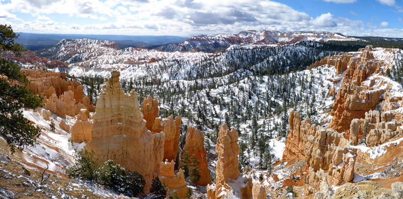
When combined with a 2.5 mile section of the Rim Trail, the Fairyland Trail makes an 8.3 mile loop through some of the most spectacular landscapes in Bryce Canyon National Park, towards the north edge of the formations; across two major ravines (Fairyland Canyon and Campbell Canyon), and several ridges. The scenery is varied, alternating between confined and open, wooded and treeless, high and low, and the views are ever-changing along the whole loop.
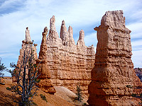
Hoodoos are always present, sometimes viewed close up where the path moves between many colorful, rocky outcrops, and in other places from afar since the higher parts of the route overlook many square miles of the surroundings. The path traverses land generally lower in elevation than others further south, and much of the route crosses exposed slopes, making the hike hot in summer but accessible earlier in the season since the snowfall is somewhat lighter, and melts more readily.
The scenery is comparable with the other two top hikes in the park, Queens Garden and Peekaboo, and the full route, while still popular, is not as busy since it is long, and somewhat strenuous; the exception is the southernmost 2 miles, to the famous formation of Tower Bridge; as this always sees many visitors, starting from Sunrise Point which is one of the two trailheads for the loop. The other is at Fairyland Point to the north, and the route can be hiked in either direction, giving four options for the hike. It is perhaps best to walk the mostly level rim section first, giving an appreciation of the wider landscape before descending amongst the hoodoos, and therefore ending with the rather steep climb back to the rim; also, Fairyland Point is closed due to snow in winter (the access road is not plowed) and has more limited parking, hence the preferred option is to park at Sunrise Point and walk the loop clockwise; along the rim to Fairyland Point then down the Fairyland Trail, and this is the route described below. There is plenty of parking at Sunrise Point, and several nearby places.
Overview map for Bryce Canyon National Park, Fairyland Trail topographic map.
29 views along the Fairyland Trail.
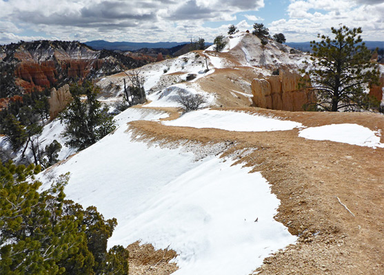
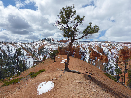
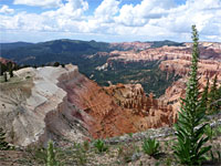
The northwards section of the Rim Trail in the vicinity of Sunrise Point is level at first as it passes close to various buildings, parking areas and a campground, before rising slightly as it moves into undeveloped land along a narrow ridgeline, sparsely wooded, and so generally in full view of the formations below to the east, around the upper end of Campbell Canyon. The path climbs slightly up an open slope, moving away from the rim for a short distance then cutting back to a small plateau at 8,155 feet, the high point of the hike, giving more spectacular views eastwards. Past here the path drops gradually down into more forested ground, staying right beside the rim for half a mile before crossing a saddle at the west end of Boat Mesa, a narrow, promontory that forms a divide between Campbell Canyon to the south and Fairyland Canyon to the north. Not far beyond, the trail reaches the parking area at Fairyland Point, where a sign gives the distance back to Sunrise Point as 2.5 miles. This is the north end of the Rim Trail.
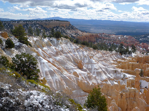
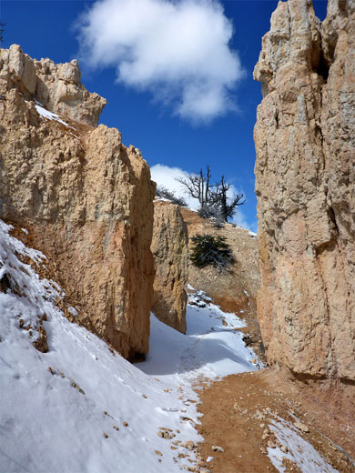
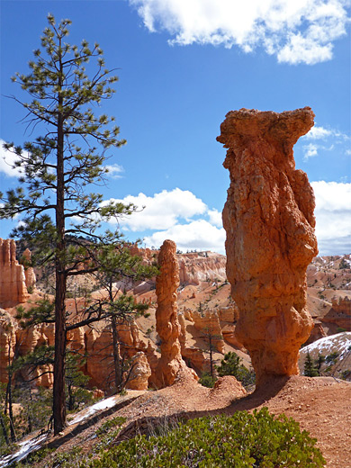
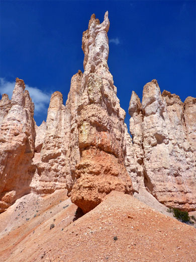
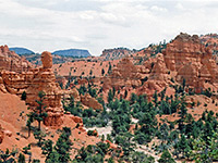
The Fairyland Trail begins at the northern terminus of the Rim Trail, descending a barren slope at the upper end of a tributary of Fairyland Canyon, past a sign marking the edge of the Bryce Canyon Wilderness, later coming close to the top of a ridge and descending a little more to a bench with pine trees, followed by a short set of switchbacks down into the upper end of a wooded ravine, which downstream quickly becomes deeper and wider. The land opens out, with fewer trees, and rises gently to a saddle, followed by more descending, past plenty of slender pinnacles, mixed with the pine trees. The path soon climbs again, past a particularly photogenic group of spires, round a corner into a wide basin, up to promontory and on to a steeper slope, with switchbacks, leading to the top of a flat, clayish ridge, where the route moves round to the northeast, heading back towards Boat Mesa. This is the most easterly point on the trail, and the ridge affords the best all-round views, from cliffs north of Fairyland Canyon and the angular formation of Sinking Ship, across the lower valley of Campbell Creek, with the town of Tropic beyond, and south over Bristlecone Point and other summits. The ridge is about one third of the way along the Fairyland Trail.
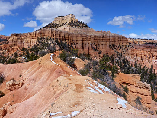
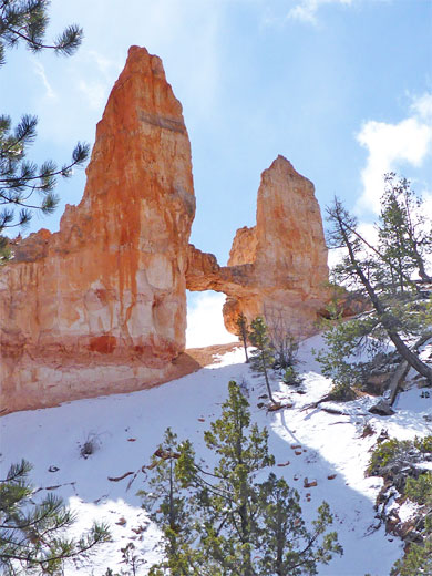
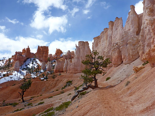
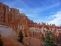
The Fairyland Trail continues with a long, smooth curve, descending quite gently to a promontory below Boat Mesa, then cuts sharply back to the north, moving below the promontory across sandy slopes above the main streambed of Campbell Canyon, 500 feet below. The trail moves in and out of two shallow, wooded ravines, round a protruding cliff and across several smaller valleys, then descends more steeply, beneath a line of shapely, light-colored pinnacles, after which Tower Bridge comes into view, on the far side of the canyon. The end of the descent, in the streambed, is marked by a sign to the 800 foot spur trail to a viewpoint of the bridge; the onward distance is 1.7 miles, to Sunrise Point. The canyon floor hereabouts is quite thickly wooded, and the spur ends at a viewpoint amongst the trees, 50 feet below the span; the sun tends to shine from behind, so the feature is not always easy to photograph effectively. A fainter, unofficial trail climbs the slope to the base of the bridge.
The main Fairyland Trail heads upstream on the floor of Campbell Canyon for a quarter of a mile, a shady section beneath tall, well-spaced trees, then ascends via some steep switchbacks to a ridge, within sight of Chinese Wall to the south - a long array of spires. The next stretch is nearly level, running along the base of another line of pinnacles, through a narrow gap between two of them followed by more climbing on the far side. Ahead, the land is briefly open and exposed, before becoming wooded for the reminder of the hike to Sunrise Point on the rim; a few switchbacks then a long, gentle, upwards curve.
Hoodoos are always present, sometimes viewed close up where the path moves between many colorful, rocky outcrops, and in other places from afar since the higher parts of the route overlook many square miles of the surroundings. The path traverses land generally lower in elevation than others further south, and much of the route crosses exposed slopes, making the hike hot in summer but accessible earlier in the season since the snowfall is somewhat lighter, and melts more readily.
The scenery is comparable with the other two top hikes in the park, Queens Garden and Peekaboo, and the full route, while still popular, is not as busy since it is long, and somewhat strenuous; the exception is the southernmost 2 miles, to the famous formation of Tower Bridge; as this always sees many visitors, starting from Sunrise Point which is one of the two trailheads for the loop. The other is at Fairyland Point to the north, and the route can be hiked in either direction, giving four options for the hike. It is perhaps best to walk the mostly level rim section first, giving an appreciation of the wider landscape before descending amongst the hoodoos, and therefore ending with the rather steep climb back to the rim; also, Fairyland Point is closed due to snow in winter (the access road is not plowed) and has more limited parking, hence the preferred option is to park at Sunrise Point and walk the loop clockwise; along the rim to Fairyland Point then down the Fairyland Trail, and this is the route described below. There is plenty of parking at Sunrise Point, and several nearby places.
Maps
Overview map for Bryce Canyon National Park, Fairyland Trail topographic map.
Photographs
29 views along the Fairyland Trail.
The Rim Trail
The northwards section of the Rim Trail in the vicinity of Sunrise Point is level at first as it passes close to various buildings, parking areas and a campground, before rising slightly as it moves into undeveloped land along a narrow ridgeline, sparsely wooded, and so generally in full view of the formations below to the east, around the upper end of Campbell Canyon. The path climbs slightly up an open slope, moving away from the rim for a short distance then cutting back to a small plateau at 8,155 feet, the high point of the hike, giving more spectacular views eastwards. Past here the path drops gradually down into more forested ground, staying right beside the rim for half a mile before crossing a saddle at the west end of Boat Mesa, a narrow, promontory that forms a divide between Campbell Canyon to the south and Fairyland Canyon to the north. Not far beyond, the trail reaches the parking area at Fairyland Point, where a sign gives the distance back to Sunrise Point as 2.5 miles. This is the north end of the Rim Trail.
Fairyland Canyon
The Fairyland Trail begins at the northern terminus of the Rim Trail, descending a barren slope at the upper end of a tributary of Fairyland Canyon, past a sign marking the edge of the Bryce Canyon Wilderness, later coming close to the top of a ridge and descending a little more to a bench with pine trees, followed by a short set of switchbacks down into the upper end of a wooded ravine, which downstream quickly becomes deeper and wider. The land opens out, with fewer trees, and rises gently to a saddle, followed by more descending, past plenty of slender pinnacles, mixed with the pine trees. The path soon climbs again, past a particularly photogenic group of spires, round a corner into a wide basin, up to promontory and on to a steeper slope, with switchbacks, leading to the top of a flat, clayish ridge, where the route moves round to the northeast, heading back towards Boat Mesa. This is the most easterly point on the trail, and the ridge affords the best all-round views, from cliffs north of Fairyland Canyon and the angular formation of Sinking Ship, across the lower valley of Campbell Creek, with the town of Tropic beyond, and south over Bristlecone Point and other summits. The ridge is about one third of the way along the Fairyland Trail.
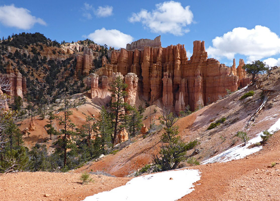
Campbell Canyon and Tower Bridge
The Fairyland Trail continues with a long, smooth curve, descending quite gently to a promontory below Boat Mesa, then cuts sharply back to the north, moving below the promontory across sandy slopes above the main streambed of Campbell Canyon, 500 feet below. The trail moves in and out of two shallow, wooded ravines, round a protruding cliff and across several smaller valleys, then descends more steeply, beneath a line of shapely, light-colored pinnacles, after which Tower Bridge comes into view, on the far side of the canyon. The end of the descent, in the streambed, is marked by a sign to the 800 foot spur trail to a viewpoint of the bridge; the onward distance is 1.7 miles, to Sunrise Point. The canyon floor hereabouts is quite thickly wooded, and the spur ends at a viewpoint amongst the trees, 50 feet below the span; the sun tends to shine from behind, so the feature is not always easy to photograph effectively. A fainter, unofficial trail climbs the slope to the base of the bridge.
Return to the Rim
The main Fairyland Trail heads upstream on the floor of Campbell Canyon for a quarter of a mile, a shady section beneath tall, well-spaced trees, then ascends via some steep switchbacks to a ridge, within sight of Chinese Wall to the south - a long array of spires. The next stretch is nearly level, running along the base of another line of pinnacles, through a narrow gap between two of them followed by more climbing on the far side. Ahead, the land is briefly open and exposed, before becoming wooded for the reminder of the hike to Sunrise Point on the rim; a few switchbacks then a long, gentle, upwards curve.
Fairyland Loop Trail - Similar Hikes
All Contents © Copyright The American Southwest | Comments and Questions | Contribute | Affiliate Marketing Disclosure | Site Map