Mossy Cave Trail, Bryce Canyon National Park
Utah > Bryce Canyon National Park > Hiking > Mossy Cave Trail
Mossy Cave Trail
Along Hwy 12, away from the central park area, this route follows a small stream, actually an artificial drainage canal constructed in the 1890s, to a waterfall and a cool alcove fringed by curtains of moss
Length: 0.8 miles
Elevation change: 300 feet
Difficulty: Easy
Type: One way; doesn't link with any other routes
Usage: High
Season: All year
Trailhead: Pullout on the west side of UT 12
Rating (1-5): ★★★★★
Elevation change: 300 feet
Difficulty: Easy
Type: One way; doesn't link with any other routes
Usage: High
Season: All year
Trailhead: Pullout on the west side of UT 12
Rating (1-5): ★★★★★

Bryce Canyon National Park has two trails that start before the entrance station and so can be hiked without paying the park fee - the Fairyland Loop starting at Fairyland Point, and the Mossy Cave Trail, a 0.4 mile route that begins beside UT 12 at an elevation of 6,820 feet, about half way between Tropic and the park turn-off at Ruby's Inn.
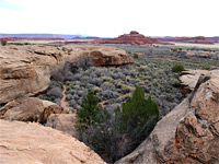
The trailhead is just beneath the Pink Cliffs, here still colorful though not very steep and generally without any spectacular formations as are found a short distance south. Instead, the path reaches a cool alcove at the base of a drop-off in quite a narrow canyon, a place sufficiently sheltered that ice from the winter remains intact well into June. A second point of interest nearby is a small waterfall, reached by a spur path.
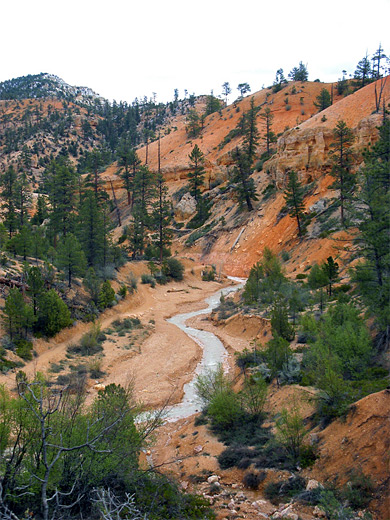
The Mossy Cave Trail is clearly signposted along the main road, and starts at a layby on the south side. It runs along a shallowish ravine (Water Canyon), which holds flowing water at least half the year during summer and fall, but the stream is not natural, instead originating from Tropic Ditch on top of the Paunsaugunt Plateau; this irrigation channel was constructed by Mormon settlers between 1890 and 1892 to supply water to Cannonville and Tropic in the dry season when the Paria River stops flowing. The ditch diverts water from the East Fork of the Sevier River - a larger drainage with a year-round flow.
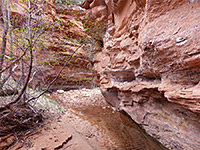
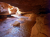
The trail is easy and mostly level, following beside the fast-flowing, sediment-laden stream, across two footbridges to a junction. The left fork has a short but steep climb through a patch of pine woodland to the cave, actually just a wide, mossy overhang in the Claron limestone, kept moist by water dripping from the ceiling. This freezes in winter, and the large ice pillars beneath do not fully melt until midsummer, partly as the cave faces northeast and hence receives no direct sunlight. The soil at the base of the grotto is often soft and muddy so the path ends at the edge; the NPS discourage people entering the alcove in order to protect the delicate hanging gardens, so there isn't much to do apart from taking photographs but the cave is interesting enough.
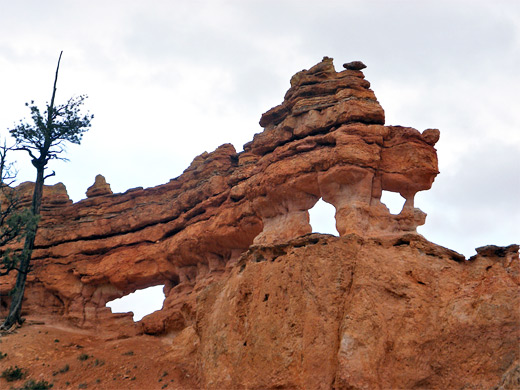
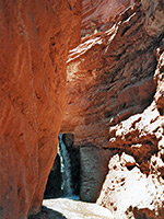
The right branch of the Mossy Cave Trail leads a little further upstream to the waterfall, where the stream tumbles 15 feet over a ledge into a circular pool; above is a swirling channel and several quite deep potholes, formed by the water eroding into the soft, orange-colored limestone. Further erosion is slowed by an underlying layer of much harder dolomite. Apart from small hoodoos and other minor formations lining the cliffs above the stream, the surroundings are wooded and gently undulating - not as scenic as the more famous section of the national park to the south, though walking off-trail further up Water Canyon might be quite interesting. If not then half an hour is enough to see both Mossy Cave and the waterfall.
The trailhead is just beneath the Pink Cliffs, here still colorful though not very steep and generally without any spectacular formations as are found a short distance south. Instead, the path reaches a cool alcove at the base of a drop-off in quite a narrow canyon, a place sufficiently sheltered that ice from the winter remains intact well into June. A second point of interest nearby is a small waterfall, reached by a spur path.
Water Canyon
The Mossy Cave Trail is clearly signposted along the main road, and starts at a layby on the south side. It runs along a shallowish ravine (Water Canyon), which holds flowing water at least half the year during summer and fall, but the stream is not natural, instead originating from Tropic Ditch on top of the Paunsaugunt Plateau; this irrigation channel was constructed by Mormon settlers between 1890 and 1892 to supply water to Cannonville and Tropic in the dry season when the Paria River stops flowing. The ditch diverts water from the East Fork of the Sevier River - a larger drainage with a year-round flow.
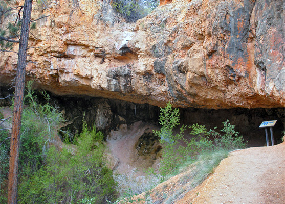
The Mossy Cave
The trail is easy and mostly level, following beside the fast-flowing, sediment-laden stream, across two footbridges to a junction. The left fork has a short but steep climb through a patch of pine woodland to the cave, actually just a wide, mossy overhang in the Claron limestone, kept moist by water dripping from the ceiling. This freezes in winter, and the large ice pillars beneath do not fully melt until midsummer, partly as the cave faces northeast and hence receives no direct sunlight. The soil at the base of the grotto is often soft and muddy so the path ends at the edge; the NPS discourage people entering the alcove in order to protect the delicate hanging gardens, so there isn't much to do apart from taking photographs but the cave is interesting enough.
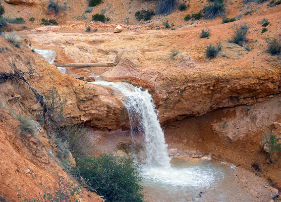
The Waterfall
The right branch of the Mossy Cave Trail leads a little further upstream to the waterfall, where the stream tumbles 15 feet over a ledge into a circular pool; above is a swirling channel and several quite deep potholes, formed by the water eroding into the soft, orange-colored limestone. Further erosion is slowed by an underlying layer of much harder dolomite. Apart from small hoodoos and other minor formations lining the cliffs above the stream, the surroundings are wooded and gently undulating - not as scenic as the more famous section of the national park to the south, though walking off-trail further up Water Canyon might be quite interesting. If not then half an hour is enough to see both Mossy Cave and the waterfall.
Mossy Cave Trail - Similar Hikes
All Contents © Copyright The American Southwest | Comments and Questions | Contribute | Affiliate Marketing Disclosure | Site Map