Queens Garden Trail, Bryce Canyon National Park
Utah > Bryce Canyon National Park > Hiking > Queens Garden Trail
Queens Garden Trail
Popular path that descends a sloping ridgeline then winds across several ravines to a sheltered basin circled by a ring of delicate, colorful hoodoos. A continuation links with other routes including the Peekaboo Trail
Length: 0.9 miles to Queens Garden, 1.6 miles to the Navajo Trail, 1.9 miles to the Peekaboo Trail
Elevation change: 320 feet, 500 feet, 500 feet
Difficulty: Easy, though steep in places
Type: One way. Can be hiked as a 2.6 mile loop, including the Navajo Trail and part of the Rim Trail
Usage: High
Season: Spring, summer, fall
Trailhead: Sunrise Point; also accessible from Sunset Point
Rating (1-5): ★★★★★

The two most popular routes that descend into the shapely formations of Bryce Canyon National Park are the Navajo Loop Trail and the Queens Garden Trail, this latter a wide and easy-to-follow path which drops down quite steeply along a ridge, past several impressive groups of hoodoos to a sheltered, partly wooded basin surrounded on three sides by a narrow ring of colorful pinnacles. Past here the trail is less well traveled as it continues descending, through more forested terrain, to an intersection at the far end of the Navajo Trail, then soon after reaches the start of the Peekaboo Loop.
The Queens Garden hike begins near Sunrise Point, towards the north end of the Bryce Canyon plateau, and is popular due to the easy access and short distance; hundreds of people make the 1.8 mile round trip on a busy summer's day, though even this is only a small fraction of those who just visit the overlook at the plateau edge. Exposed, treeless slopes help the trail to become snow-free earlier in the season than most other Bryce Canyon routes, and it is usually fully accessible between April and November.
Overview map for Bryce Canyon National Park, topographic map of the central trails.
10 views along the Queens Garden Trail.
The closest parking for the Queens Garden hike is along the loop road to Sunrise Point and Bryce Canyon Lodge, from where the trailhead is 0.3 miles away along paved rim paths, but it is also accessible from Sunset Point a little further south, and is often hiked as part of a 2.6 mile loop with the Navajo Trail, a trip best done in the counter-clockwise direction.
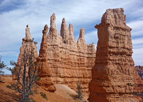
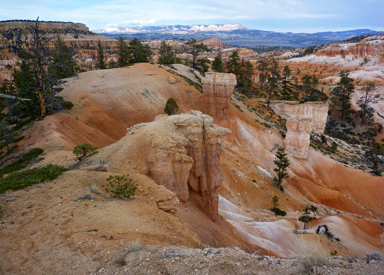
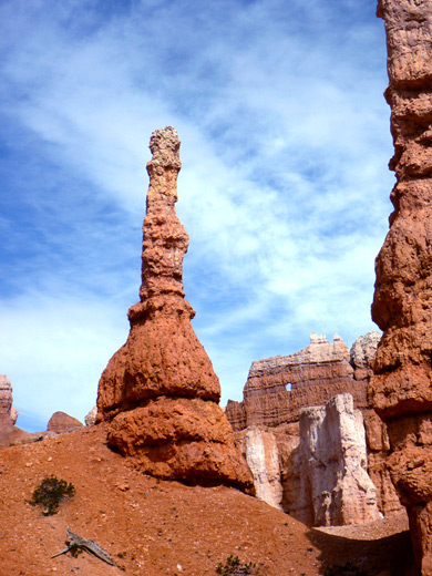
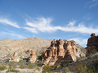
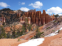
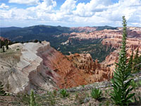
The most expansive views are near the top of the Queens Garden Trail, over a wide area of hoodoos to the north, extending towards Fairyland Canyon, and of closer formations to the south. The path descends rather steeply down a sloping ridgeline, passing several nice groups of hoodoos on the right, and reaches a promontory at the end of the ridge, soon after which is a junction with a horse trail on the left, used to bypass several narrower sections ahead. Next, the main trail passes through a short, artificial tunnel, zig zags down a hillside giving good views of a pinnacle-filled ravine, then encounters a second tunnel, a short level stretch, a third tunnel, and finally a junction, with a very short spur trail to a viewpoint of Queens Garden. The garden is a beautiful semi-circular ridge of eroded formations, high above the viewing area, formed of many thin spires colored yellow, brown, orange and pink, crossed by a whitish band lower down. At the center is a swirling, elevated formation thought to resemble Queen Victoria.
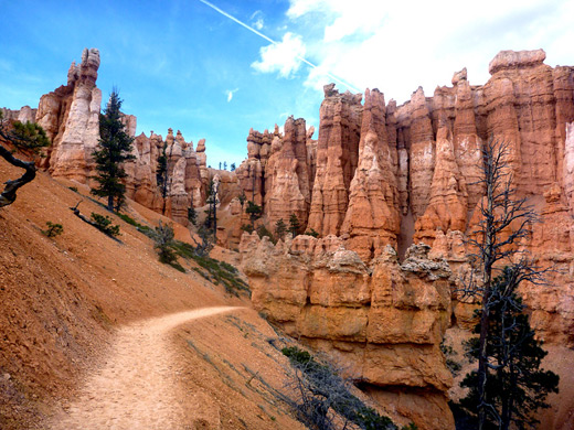
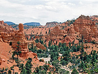
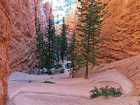
After the junction, the Queens Garden Trail descends gently alongside a dry wash, passes through a cleft in a sandstone outcrop and runs beneath an overhanging cliff, then heads down a little more steeply through wooded surroundings, where isolated hoodoos stand beside ancient pine trees. After a nearly level stretch through the forest, now lacking any formations, the path reaches two adjacent junctions (1.6 miles from the start), with the two halves of the Navajo Loop Trail. The Peekaboo Trail starts 0.3 miles further south.
The Queens Garden hike begins near Sunrise Point, towards the north end of the Bryce Canyon plateau, and is popular due to the easy access and short distance; hundreds of people make the 1.8 mile round trip on a busy summer's day, though even this is only a small fraction of those who just visit the overlook at the plateau edge. Exposed, treeless slopes help the trail to become snow-free earlier in the season than most other Bryce Canyon routes, and it is usually fully accessible between April and November.

Maps
Overview map for Bryce Canyon National Park, topographic map of the central trails.
Photographs
10 views along the Queens Garden Trail.
Queens Garden Trailhead
The closest parking for the Queens Garden hike is along the loop road to Sunrise Point and Bryce Canyon Lodge, from where the trailhead is 0.3 miles away along paved rim paths, but it is also accessible from Sunset Point a little further south, and is often hiked as part of a 2.6 mile loop with the Navajo Trail, a trip best done in the counter-clockwise direction.
Queens Garden
The most expansive views are near the top of the Queens Garden Trail, over a wide area of hoodoos to the north, extending towards Fairyland Canyon, and of closer formations to the south. The path descends rather steeply down a sloping ridgeline, passing several nice groups of hoodoos on the right, and reaches a promontory at the end of the ridge, soon after which is a junction with a horse trail on the left, used to bypass several narrower sections ahead. Next, the main trail passes through a short, artificial tunnel, zig zags down a hillside giving good views of a pinnacle-filled ravine, then encounters a second tunnel, a short level stretch, a third tunnel, and finally a junction, with a very short spur trail to a viewpoint of Queens Garden. The garden is a beautiful semi-circular ridge of eroded formations, high above the viewing area, formed of many thin spires colored yellow, brown, orange and pink, crossed by a whitish band lower down. At the center is a swirling, elevated formation thought to resemble Queen Victoria.

Trail to the Navajo Loop
After the junction, the Queens Garden Trail descends gently alongside a dry wash, passes through a cleft in a sandstone outcrop and runs beneath an overhanging cliff, then heads down a little more steeply through wooded surroundings, where isolated hoodoos stand beside ancient pine trees. After a nearly level stretch through the forest, now lacking any formations, the path reaches two adjacent junctions (1.6 miles from the start), with the two halves of the Navajo Loop Trail. The Peekaboo Trail starts 0.3 miles further south.
Queens Garden Trail - Similar Hikes
All Contents © Copyright The American Southwest | Comments and Questions | Contribute | Affiliate Marketing Disclosure | Site Map