Free permits must be obtained for all overnight trips, either from the visitor center on the day of travel or by advance reservation. Off trail hiking in the national park is generally not allowed, and is in many places restricted due to the topography, though is possible in some areas. As this is a high elevation region - all trails are over 7,000 feet and some are up to 9,000 feet - some visitors might find the hikes more difficult than would otherwise be expected.
Day hiking paths in the park are described below; most popular are the Mossy Cave, Navajo, Peekaboo and Queens Garden routes. The Bryce Canyon National Park map indicates the location of each trail.

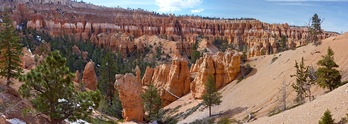
Bryce Canyon National Park Trails
Agua Canyon Trail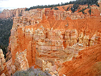 Length 1.5 miles (2.4 km) Elevation change 900 feet (274 meters) Trailhead Ponderosa Canyon overlook Rating (1-5) ★★★★★ The southernmost of four connecting paths between the Under-the-Rim Trail and the park road is a fairly steep route that descends the south side of Agua Canyon, starting near Ponderosa Canyon overlook, and meets the main trail 17 miles from its northern trailhead at Bryce Point. The formations along the edge of the plateau occur in quite a narrow band hereabouts; most of the surroundings of the path are densely wooded. |
Bristlecone Trail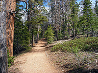 Length 1 miles (1.6 km) (loop) Elevation change 200 feet (61 meters) Trailhead Far end of the park drive Rating (1-5) ★★★★★ Bristlecone pines are the most ancient trees in the US; some specimens in California are well over 4,000 years old but those at Bryce Canyon have been growing for up to 1,600 years. They provide one attraction of a short loop trail that starts right at the southern end of the park scenic drive, at Rainbow Point (elevation 9,115 feet), and also passes many large Douglas fir trees while giving excellent views over quite extensive hoodoos and ravines to the south and west. |
Fairyland Loop Trail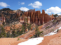 Length 8.3 miles (13.4 km) loop, including part of the Rim Trail Elevation change 950 feet (290 meters) Trailhead Fairyland Point Rating (1-5) ★★★★★ The Fairyland Trail is a relatively strenuous route starting from the most northerly park overlook at Fairyland Point, winding down amongst the hoodoos, with a total elevation loss of about 1,000 feet, then turning back southwest and climbing 770 feet up to the rim at Sunrise Point. It passes various named formations including Chinese Wall, Boat Mesa and Tower Bridge, as well as junctions with several other paths, all of which are well signposted. The full 8.3 mile loop includes a return along part of the Rim Trail. |
Hat Shop Trail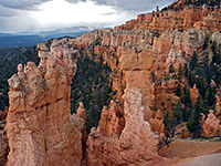 Length 2 miles (3.2 km) Elevation change 980 feet (299 meters) Trailhead Bryce Point Rating (1-5) ★★★★★ Hat Shop is the name given to a group of unusual pinnacles formed by narrow columns of soft, light-colored sandstone topped by flat boulders of more resistant rock. The path is also the upper end of the Under-the-Rim Trail, starting at Bryce Point. |
| Bryce Canyon Tours |
Mossy Cave Trail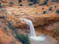 Length 0.8 miles (1.3 km) Elevation change 300 feet (91 meters) Trailhead Pullout on the west side of UT 12 Rating (1-5) ★★★★★ Mossy Cave Trail is different to most in the Bryce Canyon area as it leads along a small stream (Tropic Ditch, flowing through Water Canyon) to a waterfall and a cool alcove fringed by curtains of moss. It is located not along the main scenic drive but a few miles east on UT 12, half way down Tropic Canyon, so can be seen without paying to enter the national park. |
Navajo Trail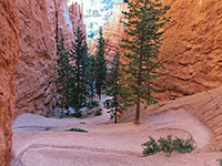 Length 1.3 miles (2.1 km) round trip Elevation change 520 feet (158 meters) Trailhead Sunset Point Rating (1-5) ★★★★★ This is a short, popular route that begins at Sunset Point and leads 520 feet downhill via a set of switchbacks into a narrow slot-like canyon known as Wall Street, returning by a parallel path alongside more formations. A continuation path further down the hill exits the park after 2 more miles, linking with a gravel road to the town of Tropic - the easiest-reached of a number of east-side entrances to the park. |
Peekaboo Trail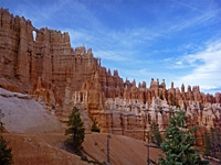 Length 5.5 miles (8.8 km) (loop) Elevation change 900 feet (274 meters) Trailhead Sunrise Point Rating (1-5) ★★★★★ Starting from Bryce Point, the Peekaboo Loop Trail is one of the longer routes through the largest area of hoodoos in the national park, around the upper end of Bryce Canyon; it drops down very steeply from the plateau edge then winds amongst innumerable colorful formations. The path is shared by horses, which can sometimes cause delays for hikers. The route may also be accessed from Sunset Point via the Navajo Trail, or by a longer walk from Sunrise Point along the Queens Garden Trail. |
Queens Garden Trail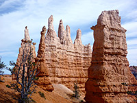 Length 0.9 miles (1.4 km) Elevation change 320 feet (98 meters) Trailhead Sunrise Point Rating (1-5) ★★★★★ The shortest path into the best area of hoodoos, around Bryce Canyon, begins at Sunrise Point and descends into a side drainage, turning back west to the base of one tower thought to resemble Queen Victoria, surrounded by a semicircle of graceful formations. Past here the path continues another 0.7 miles to link with the south end of the Navajo Loop Trail, and the Peekaboo Trail. |
Riggs Spring Trail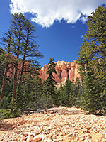 Length 8.5 miles (13.7 km) (loop) Elevation change 1650 feet (503 meters) Trailhead Rainbow Point Rating (1-5) ★★★★★ The path to Riggs Spring is one of the more difficult in Bryce Canyon National Park. It starts from Rainbow Point, the highest part of the plateau, and passes mostly through forested land, though with some eroded formations at intervals, en route to the spring, which has an elevation of 7,440 feet. From here the trail turns west then north, climbing back to the starting point. Although relatively short for a two day hike, some people camp for one night along the route, at one of 3 back country campsites. |
|
Rim Trail Length 11 miles (17.7 km) Elevation change 30 feet (9 meters) Trailhead Fairyland Point Rating (1-5) ★★★★★ As its name suggests, this trail follows the edge of the rim, from Fairyland Point to Bryce Point, around the upper ends of Campbell Canyon and Bryce Canyon; a total distance of 11 miles but with various other entrances/exits so shorter walks are possible between different locations. The most popular part is the one mile section between Sunrise and Sunset points. |
Sheep Creek Trail Length 2 miles (3.2 km) Elevation change 630 feet (192 meters) Trailhead Swamp Canyon Overlook Rating (1-5) ★★★★★ The Sheep Creek Trail is the northernmost of 4 short paths that connect with the long distance Under-the-Rim Trail; starting from Swamp Canyon overlook, the path runs northwards through thick forest, turns east and drops over the rim of the plateau, past a few hoodoos and down a wooded valley to the junction. |
Swamp Canyon Trail Length 1.3 miles (2.1 km) Elevation change 630 feet (192 meters) Trailhead Swamp Canyon Overlook Rating (1-5) ★★★★★ From Swamp Canyon overlook, a path descends into a wooded ravine between two small but pretty areas of sandstone pinnacles, and meets the Under-the-Rim Trail beside one of several back-country camp sites along this route. A 4.2 mile loop hike can be made by walking north along the main path, then back to the rim via the Sheep Creek Trail. |
Tower Bridge Trail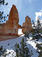 Length 1.5 miles (2.4 km) Elevation change 850 feet (259 meters) Trailhead Sunrise Point Rating (1-5) ★★★★★ This is another short, well used path that starts from Sunrise Point, descends into Fairyland Canyon and leads to the Tower Bridge formation, an eroded span resembling the famous bridge in London. The path also forms part of the Fairyland Trail. |
|
Whiteman Trail Length 0.8 miles (1.3 km) Elevation change 500 feet (152 meters) Trailhead Whiteman Bench Overlook Rating (1-5) ★★★★★ Whiteman Trail is mostly used by backpackers, as it connects to the cross-country Under-the-Rim Trail, starting from a picnic area/overlook about half way along the park scenic drive and descending into a wooded ravine, meeting the other trail beside a primitive campground. |
All Contents © Copyright The American Southwest | Comments and Questions | Contribute | Affiliate Marketing Disclosure | Site Map