Navajo Trail
The most popular short trail in the park; steep switchbacks down a cool, sheer-walled ravine to the main valley of Bryce Canyon, returning up an adjacent canyon past many formations
Length: 1.3 miles (round trip)
Elevation change: 520 feet
Difficulty: Easy
Type: Loop, linking with the Queens Garden and Peekaboo trails
Usage: High
Season: Spring, summer, fall - the western section of the trail is usually closed in winter due to the danger of falling rocks
Trailhead: Sunset Point
Rating (1-5): ★★★★★
Elevation change: 520 feet
Difficulty: Easy
Type: Loop, linking with the Queens Garden and Peekaboo trails
Usage: High
Season: Spring, summer, fall - the western section of the trail is usually closed in winter due to the danger of falling rocks
Trailhead: Sunset Point
Rating (1-5): ★★★★★

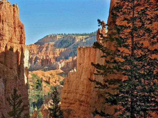
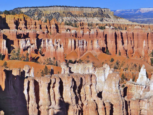
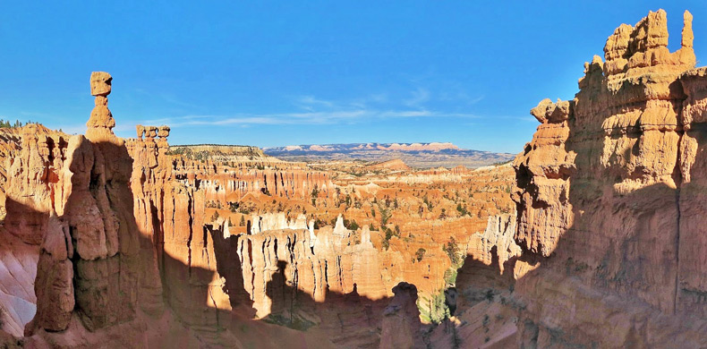
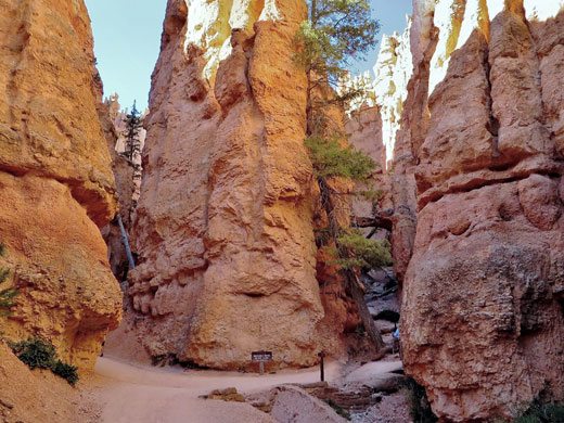
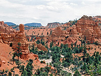
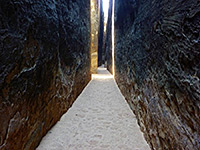
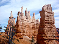
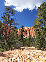
The most popular trail in Bryce Canyon National Park is the 1.3 mile Navajo Loop, which begins at the busy overlook of Sunset Point, and descends through some of the tallest fins and pinnacles in the park, down over 500 feet into the upper end of the main valley of Bryce Canyon. Both sides of the loop follow narrow ravines, one of which is very enclosed for about 300 feet, resembling a slot canyon, while the whole trail encounters contrasting scenery above and below - the upper sections have grand views over several miles of the Bryce Canyon formations, while the lower reaches are through sheltered, sandy basins, filled with large pine and fir trees.
Although the ground is steep in some parts, the trail is wide, well used and descends via gentle switchbacks, so the hike is relatively easy. The western half, which is known as Wall Street owing to the particularly high, vertical cliffs and narrow passages, is closed during winter owing to the dangers of falling rocks and compacted ice, but the eastern half is officially open all year, though may still be difficult at times of deep snow.
A junction at the far end of the loop allows for longer walks - south to the Peekaboo Trail (another 3 miles), or north along the Queens Garden Trail, an 1.6 mile route that when combined with part of the Rim Trail makes for a 3 mile circuit, using either side of the Navajo Trail. If hiking all the Navajo Loop, anticlockwise is the usual direction since the elevation changes more gradual on the return (eastern) section.
Parking for the Navajo Trail is at Sunset Point, from where nine short paths radiate out in all directions, most leading to different sections of the rim. The trailhead is southeastwards, beside the principal viewpoint, overlooking the canyon for 270 degrees; north, east and south. A sign announces 'loose rocks, steep trail, boots recommended'.
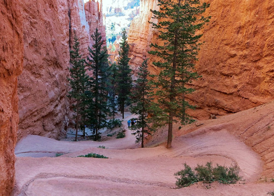
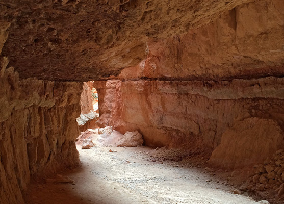
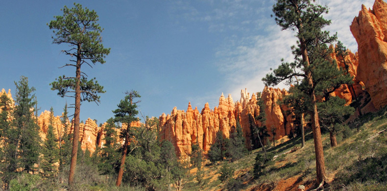
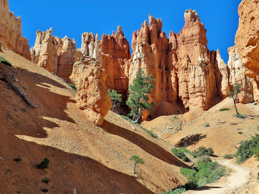
The path moves down by one switchback, over light-colored earthen slopes, to a junction; left is the slightly less steep and less enclosed east side of the loop, known as Two Bridges on account of a double arch in an adjacent ravine, while right is the narrower and steeper Wall Street section. Both sides pass close to the biggest formations for only about a third of the distance, as the lower two thirds are through partly wooded, more open terrain, below the main band of cliffs. On the western side, a short spur leads to an overlook of an adjacent ravine, viewed through a little tunnel cut in the cliffs, while the main trail starts a series of tight switchbacks, descending into a narrowing ravine between crumbling orange walls. Very little vegetation grows here, due to the unstable soil and low light levels, and the ravine becomes quite dark for a few hundred feet in the slot-like section. This opens out to a shallower valley where a few Douglas fir trees grow at the base of the cliffs, reaching up towards the sun, and soon the drainage is relatively wide, the cliffs recede, and the surroundings are more generally forested.
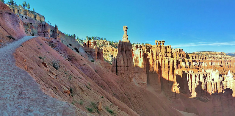
The Navajo Trail continues along the east bank of a sandy streambed to a four-way junction, with the Peekaboo Loop southeast, Queens Garden northeast and the return part of the Navajo Loop northwest. This starts climbing up a grey, wooded slope as the cliffs on each side become gradually taller and closer together, though not to the same extent as on the west side - tall trees persist most of the way to the top of the ravine. The final section of the path winds up another set of tight zig-zags, ending with a more open stretch in sight of many pinnacles, including the distinctive shape of Thor's Hammer, a sizeable block on top of a slender pedestal.
Although the ground is steep in some parts, the trail is wide, well used and descends via gentle switchbacks, so the hike is relatively easy. The western half, which is known as Wall Street owing to the particularly high, vertical cliffs and narrow passages, is closed during winter owing to the dangers of falling rocks and compacted ice, but the eastern half is officially open all year, though may still be difficult at times of deep snow.
A junction at the far end of the loop allows for longer walks - south to the Peekaboo Trail (another 3 miles), or north along the Queens Garden Trail, an 1.6 mile route that when combined with part of the Rim Trail makes for a 3 mile circuit, using either side of the Navajo Trail. If hiking all the Navajo Loop, anticlockwise is the usual direction since the elevation changes more gradual on the return (eastern) section.
Navajo Trailhead
Parking for the Navajo Trail is at Sunset Point, from where nine short paths radiate out in all directions, most leading to different sections of the rim. The trailhead is southeastwards, beside the principal viewpoint, overlooking the canyon for 270 degrees; north, east and south. A sign announces 'loose rocks, steep trail, boots recommended'.
West Section of the Loop
The path moves down by one switchback, over light-colored earthen slopes, to a junction; left is the slightly less steep and less enclosed east side of the loop, known as Two Bridges on account of a double arch in an adjacent ravine, while right is the narrower and steeper Wall Street section. Both sides pass close to the biggest formations for only about a third of the distance, as the lower two thirds are through partly wooded, more open terrain, below the main band of cliffs. On the western side, a short spur leads to an overlook of an adjacent ravine, viewed through a little tunnel cut in the cliffs, while the main trail starts a series of tight switchbacks, descending into a narrowing ravine between crumbling orange walls. Very little vegetation grows here, due to the unstable soil and low light levels, and the ravine becomes quite dark for a few hundred feet in the slot-like section. This opens out to a shallower valley where a few Douglas fir trees grow at the base of the cliffs, reaching up towards the sun, and soon the drainage is relatively wide, the cliffs recede, and the surroundings are more generally forested.
East Section of the Loop
The Navajo Trail continues along the east bank of a sandy streambed to a four-way junction, with the Peekaboo Loop southeast, Queens Garden northeast and the return part of the Navajo Loop northwest. This starts climbing up a grey, wooded slope as the cliffs on each side become gradually taller and closer together, though not to the same extent as on the west side - tall trees persist most of the way to the top of the ravine. The final section of the path winds up another set of tight zig-zags, ending with a more open stretch in sight of many pinnacles, including the distinctive shape of Thor's Hammer, a sizeable block on top of a slender pedestal.
Navajo Trail - Similar Hikes
All Contents © Copyright The American Southwest | Comments and Questions | Contribute | Affiliate Marketing Disclosure | Site Map