Pa'rus Trail
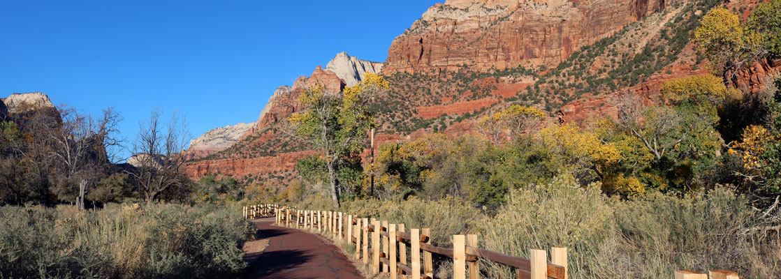
Paved path alongside the Virgin River, mostly on the east side, between Zion Canyon Visitor Center and Canyon Junction. The surroundings are grassy meadows with cottonwoods, bushes and yucca, surrounded by the high red cliffs of the canyon. Hikers share the path with cyclists, and it is also well suited for wheelchairs
Length: 1.7 miles
Elevation change: 40 feet
Difficulty: Easy
Type: One way
Usage: High
Season: All year
Trailhead: Road to Zion Canyon Visitor Center
Rating (1-5): ★★★★★
Elevation change: 40 feet
Difficulty: Easy
Type: One way
Usage: High
Season: All year
Trailhead: Road to Zion Canyon Visitor Center
Rating (1-5): ★★★★★

The Pa'rus Trail is a relatively recently-created route (1995) in Zion National Park, virtually level and fully paved, running right next to the Virgin River, from the visitor center northwards to the road bridge at Canyon Junction, a distance of 1.7 miles. The path is also open to cycles, and pets, and all is wheelchair-accessible.
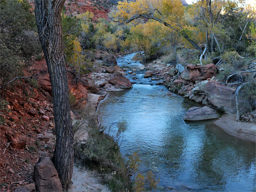
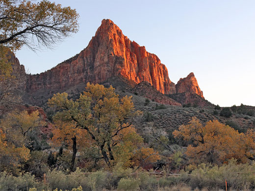
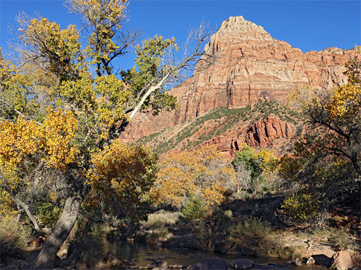
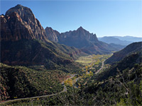
More distant views are of the dramatic red and white cliffs on both sides, including such well-known landmarks as Streaked Wall, the Beehives and the Sentinel to the west, the Watchman, East Temple and Bridge Mountain to the east, while the foreground is a mix of meadows and patches of cottonwood trees, plus the river itself, easily reachable in many places. Many wildflowers can be seen in early summer, and mule deer are often glimpsed. The hike is best around sunset, when the red cliffs to the east are especially colorful.
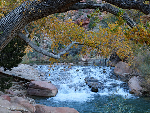
Pa'rus is a Paiute phrase meaning 'bubbling water', related to Parunuweap ('roaring water'), the name of the deep canyon of the East Fork of the Virgin River a few miles South. Zion Canyon itself was once known by another Paiute term, Mukuntuweap Canyon, meaning straight water. The river does usually flow gently in the section alongside the trail, with just one small set of rapids, this an artificial feature, a diversion dam, used to create a deep pool, from which water is piped to Springdale.
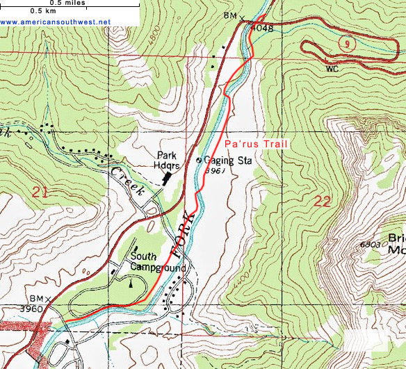
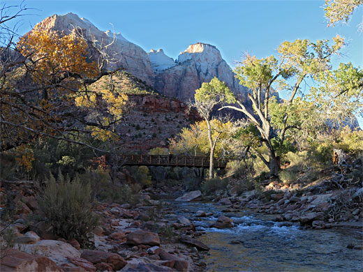
The Pa'rus Trail begins in the south at the bridge along the road to the visitor center, and it follows the west side of the river upstream, initially through sparsely wooded land beside the South Campground and the adjacent amphitheater. It crosses the road to the Watchman Campground, winds through a sagebrush meadow then moves to the east bank of the river via the first of three footbridges. For a third of a mile the path runs just beyond the overgrown surroundings of the river corridor, traversing a dry slope below the red rock cliffs, then passes back to the west side across the second bridge, the downstream view from which is one of the most photographed in the park - a straight, tree-lined section of the river with Watchman Peak beyond. Just north of the bridge is the weir formed by the diversion dam, with pool above. After a patch of woods the trail soon crosses again to the east side, closely followed by another bridge, over the Pine Creek tributary, and finally under the road bridge at Canyon Junction, up to the road, where it ends, beside the Canyon Junction shuttle stop.
More distant views are of the dramatic red and white cliffs on both sides, including such well-known landmarks as Streaked Wall, the Beehives and the Sentinel to the west, the Watchman, East Temple and Bridge Mountain to the east, while the foreground is a mix of meadows and patches of cottonwood trees, plus the river itself, easily reachable in many places. Many wildflowers can be seen in early summer, and mule deer are often glimpsed. The hike is best around sunset, when the red cliffs to the east are especially colorful.
Pa'rus is a Paiute phrase meaning 'bubbling water', related to Parunuweap ('roaring water'), the name of the deep canyon of the East Fork of the Virgin River a few miles South. Zion Canyon itself was once known by another Paiute term, Mukuntuweap Canyon, meaning straight water. The river does usually flow gently in the section alongside the trail, with just one small set of rapids, this an artificial feature, a diversion dam, used to create a deep pool, from which water is piped to Springdale.
The Trail
The Pa'rus Trail begins in the south at the bridge along the road to the visitor center, and it follows the west side of the river upstream, initially through sparsely wooded land beside the South Campground and the adjacent amphitheater. It crosses the road to the Watchman Campground, winds through a sagebrush meadow then moves to the east bank of the river via the first of three footbridges. For a third of a mile the path runs just beyond the overgrown surroundings of the river corridor, traversing a dry slope below the red rock cliffs, then passes back to the west side across the second bridge, the downstream view from which is one of the most photographed in the park - a straight, tree-lined section of the river with Watchman Peak beyond. Just north of the bridge is the weir formed by the diversion dam, with pool above. After a patch of woods the trail soon crosses again to the east side, closely followed by another bridge, over the Pine Creek tributary, and finally under the road bridge at Canyon Junction, up to the road, where it ends, beside the Canyon Junction shuttle stop.
Topographic Map of the Pa'rus Trail
Nearby Trails
Pa'rus Trail - Similar Hikes
All Contents © Copyright The American Southwest | Comments and Questions | Contribute | Affiliate Marketing Disclosure | Site Map