Boquillas Canyon, Big Bend National Park
Texas > Big Bend National Park > The Southeast > Hiking > Boquillas Canyon
Boquillas Canyon
The maintained trail to the mouth of Boquillas Canyon passes through an overgrown riparian area and ends at a pebbly beach beside the Rio Grande, but it is possible to continue downstream when the water is low - by a combination of wading and walking along sand banks - for a rather more adventuorous hike
Length: 0.7 miles
Elevation change: 40 feet
Difficulty: Easy
Type: One way; off trail continuation hikes are possible
Usage: High
Season: All year; less popular during the heat of summer
Trailhead: End of the paved road running east from Rio Grande Village
Rating (1-5): ★★★★★
Elevation change: 40 feet
Difficulty: Easy
Type: One way; off trail continuation hikes are possible
Usage: High
Season: All year; less popular during the heat of summer
Trailhead: End of the paved road running east from Rio Grande Village
Rating (1-5): ★★★★★

Boquillas Canyon is the easternmost of the three main narrows sections along the Rio Grande within Big Bend National Park; it is about 20 miles long, starting just east of Rio Grande Village a point where the river is officially 'wild and scenic', a designation it retains all the way to the Terrel/Val Verde county line near Amistad NRA.
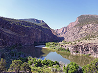
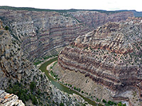
Boquillas is not as deep or sheer as Santa Elena, nor as rugged as Marsical but is still very impressive. At low water levels, the canyon may be explored on foot but for most of the year, a boat is the only option - the water is deep and fast flowing.
Map of Big Bend National Park.
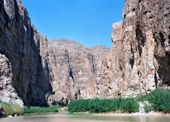
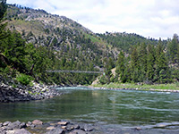
The canyon is in the far southeast corner of the park along road 118, past the Rio Grande campsite and a turn-off leading to an unofficial border crossing to the village of Boquillas del Carmen, Mexico. The approach is quite dramatic - the high, layered cliffs around the river are topped by huge, angular mountains on the Mexican side of the river, part of the Maderas Del Carmen Protected Area. At the end of the road, a well-used 0.7 mile path leads up and over a stony ridge, though a sandy area with thick bamboo then out onto a pebble beach at riverside. Gaunt cliffs tower above, and close in downstream. A distinctive feature on the Texas side is a large sand drift half way up the cliffs, formed by the prevailing winds blowing sand from the desert into the mouth of the canyon.
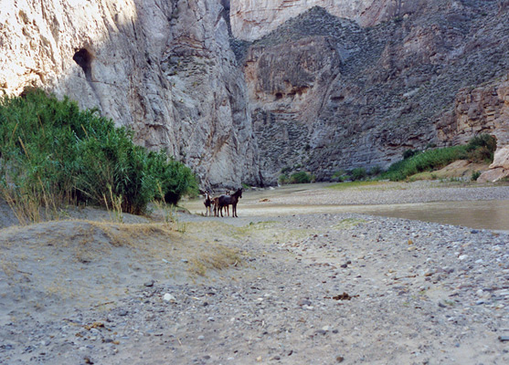
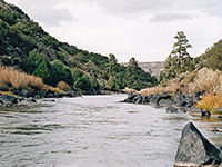
The canyon downstream is explorable if the water at this point is 2 feet deep or less - by repeated crossings between quite extensive, overgrown sandbanks at either side, at least 2 miles may be followed. There are well-defined tracks through the undergrowth beside the river, made by the mules and semi-wild horses which inhabit this area. The only other overland access route into Boquillas Canyon is by the difficult Marufo Vega Trail, which meets the river 7 miles east of the entrance.
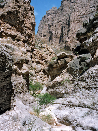
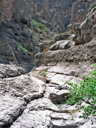
1.5 miles and 4 river crossings from the end of the official trail, a narrow side canyon joins from the north side and provides an excellent diversion. A little way along, the noise of the river is left behind and the surroundings are much more peaceful, with a greatly heightened sense of remoteness. The path along Boquillas Canyon is on the south side at this point so another crossing is required, followed by negotiation of 20 yards of thick bamboo growing in the sandy streambed and climbing a 15 foot dryfall. This end section of the canyon has pools and/or sticky mud in rainy weather. Above the dryfall and beyond, the canyon is rocky and much more open although in places quite overgrown with bushes and cacti. There are narrow, water-carved channels, other dryfalls and occasional large boulders partially blocking the streambed, but no major obstacles.
Boquillas is not as deep or sheer as Santa Elena, nor as rugged as Marsical but is still very impressive. At low water levels, the canyon may be explored on foot but for most of the year, a boat is the only option - the water is deep and fast flowing.
Location
Map of Big Bend National Park.
The Approach
The canyon is in the far southeast corner of the park along road 118, past the Rio Grande campsite and a turn-off leading to an unofficial border crossing to the village of Boquillas del Carmen, Mexico. The approach is quite dramatic - the high, layered cliffs around the river are topped by huge, angular mountains on the Mexican side of the river, part of the Maderas Del Carmen Protected Area. At the end of the road, a well-used 0.7 mile path leads up and over a stony ridge, though a sandy area with thick bamboo then out onto a pebble beach at riverside. Gaunt cliffs tower above, and close in downstream. A distinctive feature on the Texas side is a large sand drift half way up the cliffs, formed by the prevailing winds blowing sand from the desert into the mouth of the canyon.
Downstream
The canyon downstream is explorable if the water at this point is 2 feet deep or less - by repeated crossings between quite extensive, overgrown sandbanks at either side, at least 2 miles may be followed. There are well-defined tracks through the undergrowth beside the river, made by the mules and semi-wild horses which inhabit this area. The only other overland access route into Boquillas Canyon is by the difficult Marufo Vega Trail, which meets the river 7 miles east of the entrance.
A Side Canyon
1.5 miles and 4 river crossings from the end of the official trail, a narrow side canyon joins from the north side and provides an excellent diversion. A little way along, the noise of the river is left behind and the surroundings are much more peaceful, with a greatly heightened sense of remoteness. The path along Boquillas Canyon is on the south side at this point so another crossing is required, followed by negotiation of 20 yards of thick bamboo growing in the sandy streambed and climbing a 15 foot dryfall. This end section of the canyon has pools and/or sticky mud in rainy weather. Above the dryfall and beyond, the canyon is rocky and much more open although in places quite overgrown with bushes and cacti. There are narrow, water-carved channels, other dryfalls and occasional large boulders partially blocking the streambed, but no major obstacles.
Boquillas Canyon - Similar Hikes
All Contents © Copyright The American Southwest | Comments and Questions | Contribute | Affiliate Marketing Disclosure | Site Map