Lost Mine Trail, Big Bend National Park
Texas > Big Bend National Park > Chisos Mountains and the North > Hiking > Lost Mine Trail
Lost Mine Trail
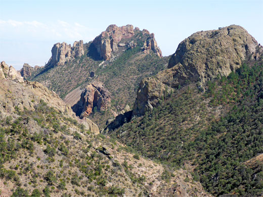
Well-used route that ascends a bushy valley to a saddle, at the head of Juniper Canyon, then climbs more steeply to a viewpoint on a high ridge, formed of colorful volcanic rocks; grand views over the rugged peaks and cliffs of the Chisos Mountains
Length: 2.4 miles
Elevation change: 1,200 feet
Difficulty: Moderate
Type: One way
Usage: High
Season: All year
Trailhead: Pullout near the end of the road into Chisos Basin
Rating (1-5): ★★★★★
Elevation change: 1,200 feet
Difficulty: Moderate
Type: One way
Usage: High
Season: All year
Trailhead: Pullout near the end of the road into Chisos Basin
Rating (1-5): ★★★★★

To fully enjoy the hiking in the Chisos Mountains requires spending at least one night in a back country campsite; the Lost Mine Trail is one of the shorter paths and is perhaps the best choice for a half day trip. The route passes varied scenery with views over several different sections of the mountains, and ends at a dramatic rocky ridge at 6,850 feet.
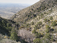
The trail first follows the upper portion of a valley (Green Gulch) - the lower reaches of which provide a course for the approach road, climbing to a divide between it and the much larger Juniper Canyon, then ascends more steeply to the ridge. The round trip is 4.8 miles, the elevation gain 1,200 feet. The middle part of the hike is quite strenuous, switchbacking up the slopes.
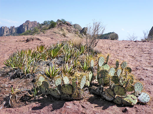
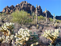
All of the bedrock is volcanic in origin; white tuff facies near the start, to a little way beyond the divide, then darker rhyolitic deposits beyond, from the Boot Rock Member of the South Rim Formation, which is mostly gray-brown though enlivened in some places by patches of pink and green. Vegetation includes small pine trees, agave and red-flowered hedgehog cacti.
Map of Big Bend National Park.
23 views along the Lost Mine Trail.
The Lost Mine Trail starts at 5,650 feet; the trailhead is along the entrance road into the Chisos Mountains, just after the highpoint at Panther Pass, and before the steep winding descent into Chisos Basin. The trailhead is provided with a parking area that accommodates only around 16 vehicles so is often full. There is room for a few more cars at small pull-outs in either direction.
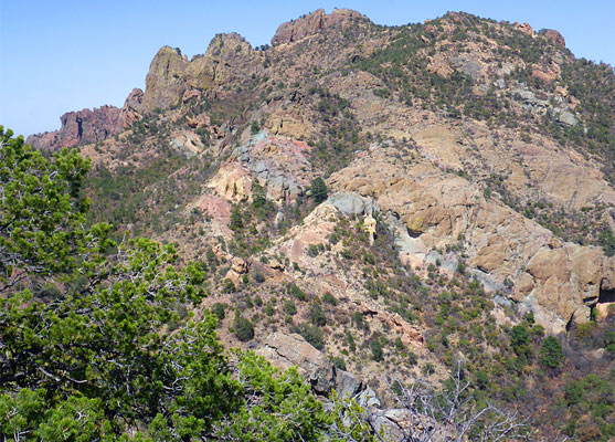
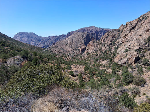
At first, the walk is across the lower slopes of Casa Grande Peak, on the north-facing side of Green Gulch, a relatively sheltered valley with pine, juniper and fir trees. The trail is wide and well-used, the surroundings often rather dry and dusty. After 0.8 miles the path reaches a ridge at the head of the gulch; ahead lies Juniper Canyon, 1,500 feet deep, with the Chihuahuan Desert plains in the east of the park visible far beyond. To the west is a group of peaks and pinnacles, a spur off the main summit of Casa Grande Peak. Even a walk just to this point is worthwhile, but most people continue.
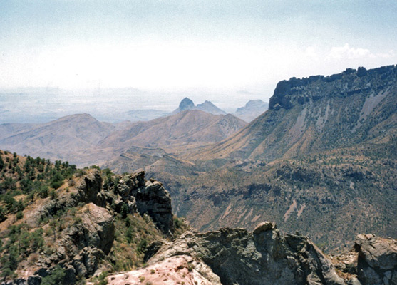
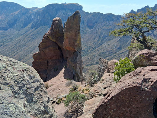
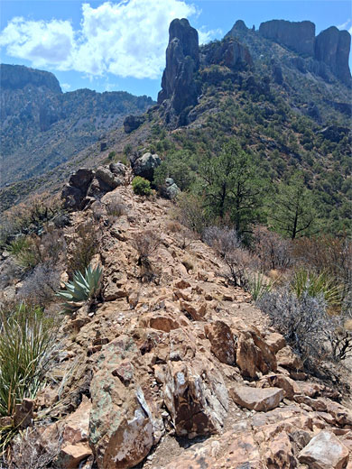
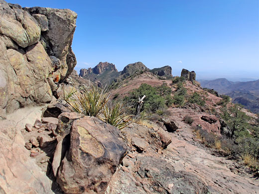
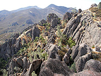
The middle third of the trail alternates between sunny, exposed land with cacti, ocotillo and lechuguilla, and more shaded patches with bushes and trees. It traverses east, with some gentle climbing, over generally open slopes, to the base of a steeper hillside then starts a series of switchbacks, with increasingly long segments. Some places are bare rock, others have loose stones. The uphill gradient is moderate but steady, as the path approaches the ridge that divides Juniper Canyon with Pine Canyon, the adjacent ravine to the north. Just before the ridge is a large monolith, a shady section, and a flight of steps. The last section of the hike is much flatter, along the ridge, which is wooded at first then mostly bare rock, and becomes gradually narrower, ending at a small summit around which the ground falls away very steeply. On all sides are shapely boulders and pinnacles of the volcanic rocks, often partly covered by brightly-colored lichen. The official endpoint of the trail is about 400 feet before this point, at an intermediate knoll, but there seems no reason not to continue to the far end of the ridge.
There are several higher peaks around the end of the trail, including 7,535 foot Lost Mine Peak, at the far side of Pine Canyon to the northeast, and Crown Mountain to the southeast. Some of the rocks on the hillside opposite are especially colorful, hinting of hidden mineral wealth, and there are stories of a rich seam of gold being discovered in this area by Spanish settlers, then supposedly lost when all were killed by Indians. The tale is unproven and no trace of such a mine in this area has ever been found.
The trail first follows the upper portion of a valley (Green Gulch) - the lower reaches of which provide a course for the approach road, climbing to a divide between it and the much larger Juniper Canyon, then ascends more steeply to the ridge. The round trip is 4.8 miles, the elevation gain 1,200 feet. The middle part of the hike is quite strenuous, switchbacking up the slopes.
All of the bedrock is volcanic in origin; white tuff facies near the start, to a little way beyond the divide, then darker rhyolitic deposits beyond, from the Boot Rock Member of the South Rim Formation, which is mostly gray-brown though enlivened in some places by patches of pink and green. Vegetation includes small pine trees, agave and red-flowered hedgehog cacti.
Location
Map of Big Bend National Park.
Photographs
23 views along the Lost Mine Trail.
Lost Mine Trail Video
Start of the Trail
The Lost Mine Trail starts at 5,650 feet; the trailhead is along the entrance road into the Chisos Mountains, just after the highpoint at Panther Pass, and before the steep winding descent into Chisos Basin. The trailhead is provided with a parking area that accommodates only around 16 vehicles so is often full. There is room for a few more cars at small pull-outs in either direction.
Green Gulch
At first, the walk is across the lower slopes of Casa Grande Peak, on the north-facing side of Green Gulch, a relatively sheltered valley with pine, juniper and fir trees. The trail is wide and well-used, the surroundings often rather dry and dusty. After 0.8 miles the path reaches a ridge at the head of the gulch; ahead lies Juniper Canyon, 1,500 feet deep, with the Chihuahuan Desert plains in the east of the park visible far beyond. To the west is a group of peaks and pinnacles, a spur off the main summit of Casa Grande Peak. Even a walk just to this point is worthwhile, but most people continue.
Climb to the Ridge
The middle third of the trail alternates between sunny, exposed land with cacti, ocotillo and lechuguilla, and more shaded patches with bushes and trees. It traverses east, with some gentle climbing, over generally open slopes, to the base of a steeper hillside then starts a series of switchbacks, with increasingly long segments. Some places are bare rock, others have loose stones. The uphill gradient is moderate but steady, as the path approaches the ridge that divides Juniper Canyon with Pine Canyon, the adjacent ravine to the north. Just before the ridge is a large monolith, a shady section, and a flight of steps. The last section of the hike is much flatter, along the ridge, which is wooded at first then mostly bare rock, and becomes gradually narrower, ending at a small summit around which the ground falls away very steeply. On all sides are shapely boulders and pinnacles of the volcanic rocks, often partly covered by brightly-colored lichen. The official endpoint of the trail is about 400 feet before this point, at an intermediate knoll, but there seems no reason not to continue to the far end of the ridge.
Legend of the Mine
There are several higher peaks around the end of the trail, including 7,535 foot Lost Mine Peak, at the far side of Pine Canyon to the northeast, and Crown Mountain to the southeast. Some of the rocks on the hillside opposite are especially colorful, hinting of hidden mineral wealth, and there are stories of a rich seam of gold being discovered in this area by Spanish settlers, then supposedly lost when all were killed by Indians. The tale is unproven and no trace of such a mine in this area has ever been found.
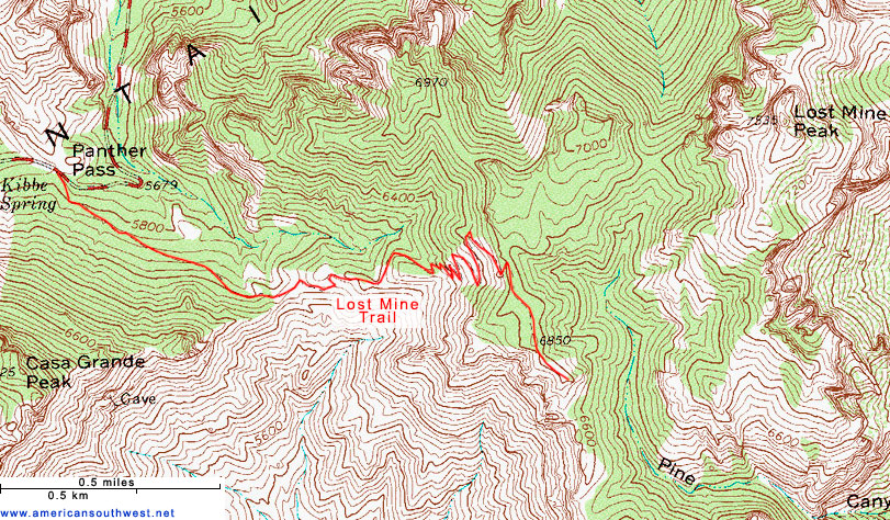
Lost Mine Trail Topo Map
Lost Mine Trail - Similar Hikes
All Contents © Copyright The American Southwest | Comments and Questions | Contribute | Affiliate Marketing Disclosure | Site Map