Blacktail Deer Creek Trail, Yellowstone National Park
Wyoming > Yellowstone National Park > The North > Hiking > Blacktail Deer Creek Trail
Blacktail Deer Creek
Blacktail Deer Creek provides the main access into the Black Canyon of the Yellowstone River from the south. Most of the trail crosses open ground with grassy meadows and patches of woodland though the last part is down a steep ravine to the river, which is crossed on a footbridge
Length: 3.5 miles
Elevation change: 1,100 feet
Difficulty: Moderate
Type: One way. One junction en route, with the Rescue Creek Trail
Usage: Low to medium
Season: Spring, summer, fall
Trailhead: Small pullout on the north side of the Grand Loop Road
Rating (1-5): ★★★★★
Elevation change: 1,100 feet
Difficulty: Moderate
Type: One way. One junction en route, with the Rescue Creek Trail
Usage: Low to medium
Season: Spring, summer, fall
Trailhead: Small pullout on the north side of the Grand Loop Road
Rating (1-5): ★★★★★

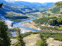
From its source on the remote Blacktail Deer Plateau, Blacktail Deer Creek flows northwards across open prairie, passes under the Grand Loop Road 6.5 miles east of Mammoth then descends into a shallow valley which gradually deepens and meets the Black Canyon of the Yellowstone River - not as spectacular as the Grand Canyon further upstream, but impressive nonetheless. A 3.5 mile trail starts along the highway and follows the lower section of the creek, crossing the river on a footbridge and ending at an intersection with the longer Yellowstone River Trail, after a descent of 1,100 feet.
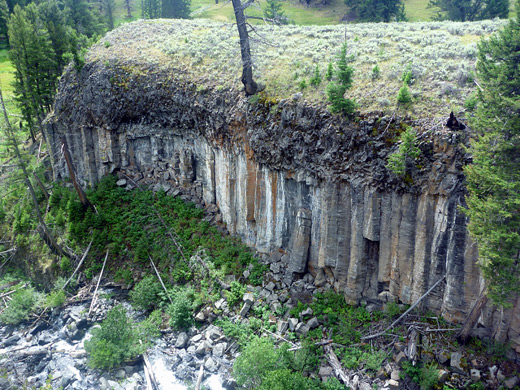
The first couple of miles traverse grassy, treeless terrain that is likely habitat for bear, bison, deer and pronghorn antelope, while the last 1.5 miles are along the valley, which starts as the stream cascades over the edge of a volcanic cliff, exposing a layer of unusual columnar lava. The path is often used by backpackers, forming part of a 20 mile loop through the lower end of Black Canyon (also involving the Rescue Creek Trail), but the trip to the river and back is a good half day hike.
Trail map for Yellowstone National Park.
10 views along the Blacktail Deer Creek Trail.
Scenes along the trail (mp4; 0:41 min; 10 mb).
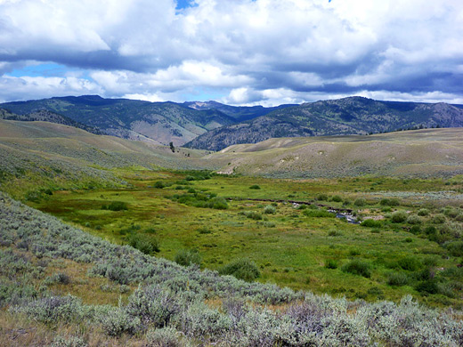
The Blacktail Deer Creek trailhead has a small, dirt parking area on the north side of the road just east of Blacktail Deer Pond, a shallow, reed-lined pool that often attracts wildlife. This section of the highway runs along the south edge of a wide, treeless valley, slightly elevated, and there are plenty of roadside pull-outs from which to look for animals.
The path heads north, past a smaller pond to the first of two signed junctions, with the long disused and more-or-less invisible Howard Eaton Trail, followed soon after by an intersection with the Rescue Creek Trail. At this point Blacktail Deer Creek is a small drainage, meandering through a marshy meadow between rolling grassy hills, dotted with grey-brown boulders that at a distance resemble a sleeping bear or bison. The path generally stays quite far away, climbing a little and passing between two fenced-off areas, then descending over the expansive slopes beyond, staying out of sight of the stream until it reaches a patch of woodland (location of primitive campsite 1A1), where the route drops down beside the creek as it starts to form a deeper valley. A line of bushes and Douglas fir trees enclose the waters, ideal black bear territory, though the surrounding hills are still grass-covered and open.
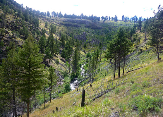
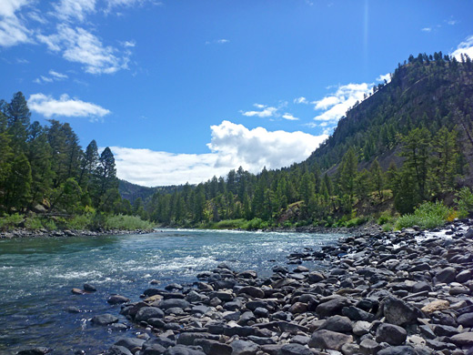
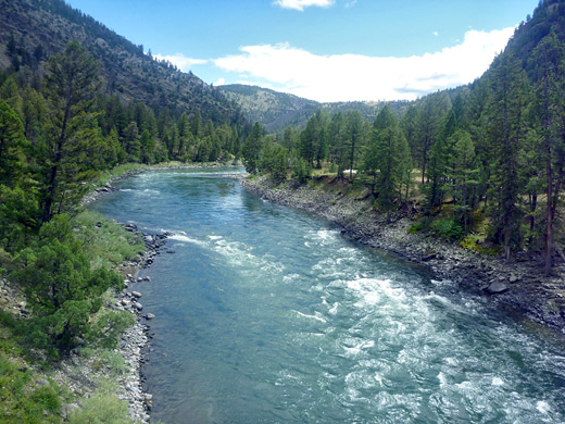
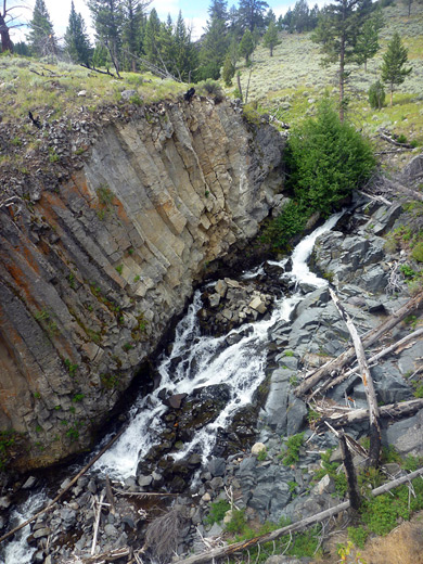
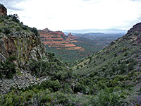
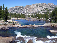
The ravine deepens more noticeably after the creek pours over the edge of a volcanic layer, forming an 80 foot cascade (see video). The rocks at either side are mostly vertical columnar basalt (like Devils Postpile in California), topped by a thinner, darker layer of jagged, amorphous lava. Past here the canyon is much bigger - V-shaped and steep sided in profile, and the path also descends more sharply, while remaining quite far above the streamway. The surroundings become predominantly wooded as the path turns due north, crosses the Wyoming-Montana stateline and approaches the Yellowstone River; the fast flowing waters can be seen from half a mile away, through gaps in the trees, but overall the views are somewhat limited during the descent owing to the tall, dense forest. At the river, a short path forks right towards a patrol cabin and 2 campsites, right beside the water, while the main trail crosses the river on a suspension bridge and climbs a little to the junction with the Yellowstone River Trail, close to Crevice Lake.
The first couple of miles traverse grassy, treeless terrain that is likely habitat for bear, bison, deer and pronghorn antelope, while the last 1.5 miles are along the valley, which starts as the stream cascades over the edge of a volcanic cliff, exposing a layer of unusual columnar lava. The path is often used by backpackers, forming part of a 20 mile loop through the lower end of Black Canyon (also involving the Rescue Creek Trail), but the trip to the river and back is a good half day hike.
Location
Trail map for Yellowstone National Park.
Photographs
10 views along the Blacktail Deer Creek Trail.
Video
Scenes along the trail (mp4; 0:41 min; 10 mb).
Blacktail Deer Creek Trailhead
The Blacktail Deer Creek trailhead has a small, dirt parking area on the north side of the road just east of Blacktail Deer Pond, a shallow, reed-lined pool that often attracts wildlife. This section of the highway runs along the south edge of a wide, treeless valley, slightly elevated, and there are plenty of roadside pull-outs from which to look for animals.
Start of the Trail
The path heads north, past a smaller pond to the first of two signed junctions, with the long disused and more-or-less invisible Howard Eaton Trail, followed soon after by an intersection with the Rescue Creek Trail. At this point Blacktail Deer Creek is a small drainage, meandering through a marshy meadow between rolling grassy hills, dotted with grey-brown boulders that at a distance resemble a sleeping bear or bison. The path generally stays quite far away, climbing a little and passing between two fenced-off areas, then descending over the expansive slopes beyond, staying out of sight of the stream until it reaches a patch of woodland (location of primitive campsite 1A1), where the route drops down beside the creek as it starts to form a deeper valley. A line of bushes and Douglas fir trees enclose the waters, ideal black bear territory, though the surrounding hills are still grass-covered and open.
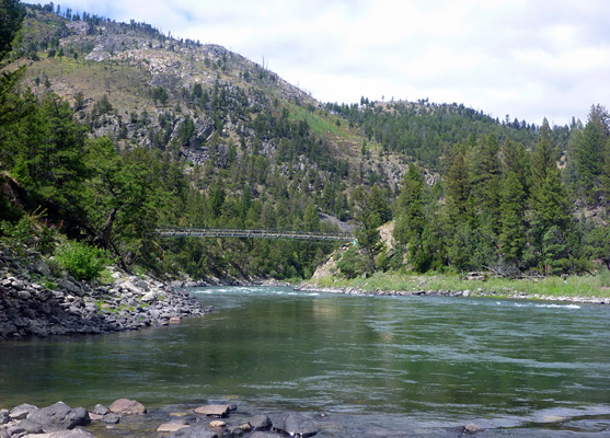
The Yellowstone River
The ravine deepens more noticeably after the creek pours over the edge of a volcanic layer, forming an 80 foot cascade (see video). The rocks at either side are mostly vertical columnar basalt (like Devils Postpile in California), topped by a thinner, darker layer of jagged, amorphous lava. Past here the canyon is much bigger - V-shaped and steep sided in profile, and the path also descends more sharply, while remaining quite far above the streamway. The surroundings become predominantly wooded as the path turns due north, crosses the Wyoming-Montana stateline and approaches the Yellowstone River; the fast flowing waters can be seen from half a mile away, through gaps in the trees, but overall the views are somewhat limited during the descent owing to the tall, dense forest. At the river, a short path forks right towards a patrol cabin and 2 campsites, right beside the water, while the main trail crosses the river on a suspension bridge and climbs a little to the junction with the Yellowstone River Trail, close to Crevice Lake.
Blacktail Deer Creek Trail - Similar Hikes
All Contents © Copyright The American Southwest | Comments and Questions | Contribute | Affiliate Marketing Disclosure | Site Map