Allens Bend and Casner Canyon Trails, Sedona
Arizona > Sedona > Hiking > Allens Bend and Casner Canyon Trails

Allens Bend and Casner Canyon Trails
#111, #11
#111, #11
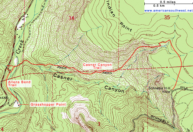
The short Allens Bend Trail parallels a wooded section of Oak Creek, running beneath low red cliffs, leading to the longer Casner Canyon Trail, which follows a wide, east-side tributary ravine, climbing steeply to the plateau and on to Schnebly Hill Vista
Length: 0.5 miles, 2.6 miles
Elevation change: level, 1,500 feet
Difficulty: Easy, moderate
Type: One way
Usage: Medium, low
Season: All year, though the middle part of Casner Canyon is exposed, and hot in summer
Trailhead: Grasshopper Point day use parking area
Rating (1-5): ★★★★★
Elevation change: level, 1,500 feet
Difficulty: Easy, moderate
Type: One way
Usage: Medium, low
Season: All year, though the middle part of Casner Canyon is exposed, and hot in summer
Trailhead: Grasshopper Point day use parking area
Rating (1-5): ★★★★★

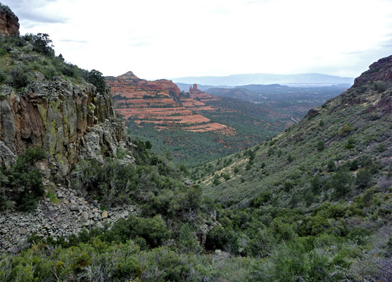
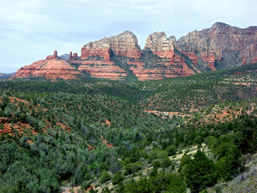
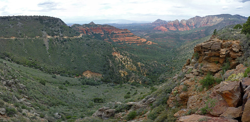
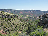
The 2.6 mile trail up the north side of Casner Canyon is one of the more lightly used paths near Sedona, despite passing varied scenery - the route starts in the wooded Oak Creek corridor, traverses the bushy canyon sides to the volcanic plateau above, and ends at Schnebly Hill Vista, which has impressive albeit quite distant views of the town and the adjoining red and white cliffs.
Reasons for the relative lack of hikers include the hidden trailhead, the crossing of Oak Creek near the start (this may require wading water up to 2 feet deep), the exposed, rather featureless slopes in the middle section of the hike - very hot in summer, and the fact that the final viewpoint is also accessible to all vehicles via Schnebly Hill Road. The path is a good one for solitude, therefore, though some parts are within sight of vehicles on the road, which reaches the upper end of Casner Canyon coming from the south, after climbing an adjacent ravine (Bear Wallow Canyon). Other attractions of the hike are an unusual cliff of columnar basalt just below the rim of the canyon, and a fine assortment of flowing plants on the plateau.
Sedona location map.
The official parking place for the Casner Canyon Trail is at a small, unsigned pull-out along US 89, one mile north of Midgley Bridge, where, beyond an iron gate, the path leads down a slope towards Oak Creek. Vehicles can also be left on the far side of the road, along a narrow verge, but most people start half mile south at the Grasshopper Point day use area, which has plenty of space, plus picnic tables, bbq grills and other facilities. An $8 fee is due for parking, however. From here the Casner Canyon Trail is reached by walking half a mile north along a connecting path, the Allens Bend Trail.
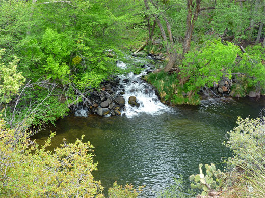
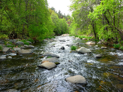
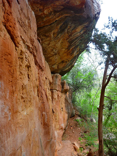
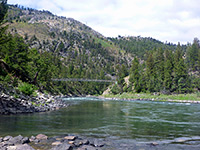
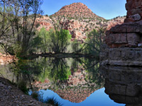
The Allens Bend Trail starts from the Grasshopper Point parking area, on flat land beside a wide bend in Oak Creek, where the surroundings are covered by long grass, bushes and trees, some from an old orchard. The trail enters the undergrowth and soon arrives at the base of a line of low red/orange cliffs of the Supai Formation, which overhang above in a few places. The path rises slightly via few stone steps and runs along rocky terraces then returns to the grassy woodland, close to the creek but mostly out of sight, though the waters can easily be reached by a few very short side trails. A junction appears after half a mile, left being a spur up to US 89, while right is the start of the Casner Canyon Trail.
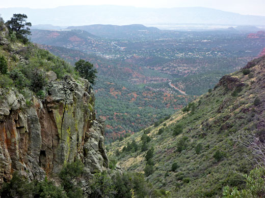
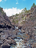
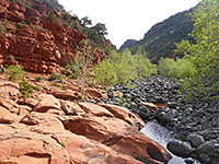
Beyond the junction, the path continues north a short distance then bends east, crossing an open, pebbly area, a (usually dry) overflow channel of Oak Creek, the route marked by a few cairns, then reaches the actual stream. The suggested crossing method is to wade, through quite fast-flowing water usually one or two feet deep in early summer, but it is also possible to jump between rocks and so keep feet dry. The trail resumes on the far side, leading to the mouth of a big side drainage - Casner Canyon - which is also dry for the majority of the time, and filled with many big red and white boulders. The path follows the south side briefly, beneath a short line of cliffs, then crosses to the north, just downstream of a semi-enclosed section that may contain residual pools. The climb starts now, through bushes and trees for a few hundred feet and out across open, exposed, arid hillsides where wildflowers are limited. The creekbed is soon far below, bordered further south by a line of red sandstone cliffs and peaks, with Sedona visible in the distance.
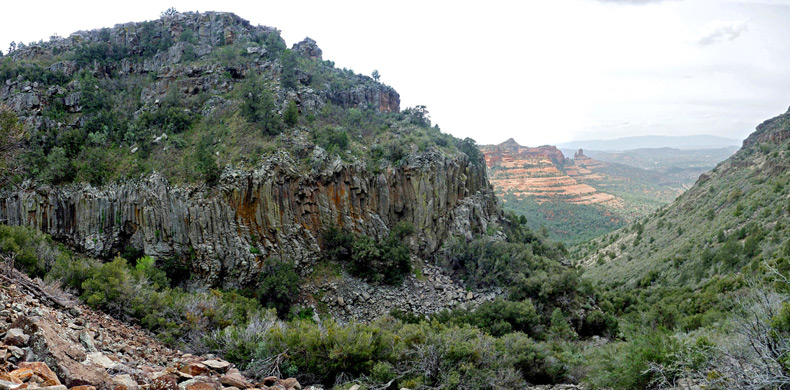
The gradient is moderately steep at first, becoming more gentle for while until the trail turns north into a tributary drainage and becomes noticeably steeper. The surface underfoot has a lot of loose stones, a particular problem when descending, and the side valley is quite overgrown, filled with spiky bushes which encroach onto the pathway, so this section of the hike is rather difficult. The drainage narrows, and the south side of the uppermost part is formed of a wall of columnar basalt, 500 feet long. Looking back along the canyon, most of the landscape is wooded, dull green in color with just a few areas of red rocks visible.
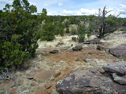
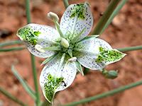
After one short switchback, through temporarily wooded surroundings, and past a fence with a gate, the path reaches the rim of the Schnebly Hill plateau; ahead is a level expanse of sand and basalt outcrops, dotted with bushes, cacti (especially echinocereus and escobaria) and a more varied selection of wildflowers than in the canyon. Fabaceae is the most common plant family, including several types of lupine and at least three astragalus species (allochrous, tephrodes, troglodytus), the last of which is rare, found only on the plateaus bordering Sedona and Flagstaff. The final half mile of the path heads south, crossing two small drainages, and ends at Schnebly Hill Vista beside Schnebly Hill Road. The last section is marked by cairns, as the way ahead is not always obvious. The viewpoint is often quite a busy place, visited by pink jeeps in addition to regular vehicles, but it is easy to find quieter areas by walking along the rim a little way. Views extend across Oak Creek valley and Sedona, to the distant Verde Valley and the Black Hills.
Reasons for the relative lack of hikers include the hidden trailhead, the crossing of Oak Creek near the start (this may require wading water up to 2 feet deep), the exposed, rather featureless slopes in the middle section of the hike - very hot in summer, and the fact that the final viewpoint is also accessible to all vehicles via Schnebly Hill Road. The path is a good one for solitude, therefore, though some parts are within sight of vehicles on the road, which reaches the upper end of Casner Canyon coming from the south, after climbing an adjacent ravine (Bear Wallow Canyon). Other attractions of the hike are an unusual cliff of columnar basalt just below the rim of the canyon, and a fine assortment of flowing plants on the plateau.
Map
Sedona location map.
Casner Canyon Trailhead
The official parking place for the Casner Canyon Trail is at a small, unsigned pull-out along US 89, one mile north of Midgley Bridge, where, beyond an iron gate, the path leads down a slope towards Oak Creek. Vehicles can also be left on the far side of the road, along a narrow verge, but most people start half mile south at the Grasshopper Point day use area, which has plenty of space, plus picnic tables, bbq grills and other facilities. An $8 fee is due for parking, however. From here the Casner Canyon Trail is reached by walking half a mile north along a connecting path, the Allens Bend Trail.
Allens Bend Trail
The Allens Bend Trail starts from the Grasshopper Point parking area, on flat land beside a wide bend in Oak Creek, where the surroundings are covered by long grass, bushes and trees, some from an old orchard. The trail enters the undergrowth and soon arrives at the base of a line of low red/orange cliffs of the Supai Formation, which overhang above in a few places. The path rises slightly via few stone steps and runs along rocky terraces then returns to the grassy woodland, close to the creek but mostly out of sight, though the waters can easily be reached by a few very short side trails. A junction appears after half a mile, left being a spur up to US 89, while right is the start of the Casner Canyon Trail.
Casner Canyon
Beyond the junction, the path continues north a short distance then bends east, crossing an open, pebbly area, a (usually dry) overflow channel of Oak Creek, the route marked by a few cairns, then reaches the actual stream. The suggested crossing method is to wade, through quite fast-flowing water usually one or two feet deep in early summer, but it is also possible to jump between rocks and so keep feet dry. The trail resumes on the far side, leading to the mouth of a big side drainage - Casner Canyon - which is also dry for the majority of the time, and filled with many big red and white boulders. The path follows the south side briefly, beneath a short line of cliffs, then crosses to the north, just downstream of a semi-enclosed section that may contain residual pools. The climb starts now, through bushes and trees for a few hundred feet and out across open, exposed, arid hillsides where wildflowers are limited. The creekbed is soon far below, bordered further south by a line of red sandstone cliffs and peaks, with Sedona visible in the distance.
Basalt
The gradient is moderately steep at first, becoming more gentle for while until the trail turns north into a tributary drainage and becomes noticeably steeper. The surface underfoot has a lot of loose stones, a particular problem when descending, and the side valley is quite overgrown, filled with spiky bushes which encroach onto the pathway, so this section of the hike is rather difficult. The drainage narrows, and the south side of the uppermost part is formed of a wall of columnar basalt, 500 feet long. Looking back along the canyon, most of the landscape is wooded, dull green in color with just a few areas of red rocks visible.
Schnebly Hill Plateau
After one short switchback, through temporarily wooded surroundings, and past a fence with a gate, the path reaches the rim of the Schnebly Hill plateau; ahead is a level expanse of sand and basalt outcrops, dotted with bushes, cacti (especially echinocereus and escobaria) and a more varied selection of wildflowers than in the canyon. Fabaceae is the most common plant family, including several types of lupine and at least three astragalus species (allochrous, tephrodes, troglodytus), the last of which is rare, found only on the plateaus bordering Sedona and Flagstaff. The final half mile of the path heads south, crossing two small drainages, and ends at Schnebly Hill Vista beside Schnebly Hill Road. The last section is marked by cairns, as the way ahead is not always obvious. The viewpoint is often quite a busy place, visited by pink jeeps in addition to regular vehicles, but it is easy to find quieter areas by walking along the rim a little way. Views extend across Oak Creek valley and Sedona, to the distant Verde Valley and the Black Hills.
Casner Canyon Map
Casner Canyon Wildflowers
More flowers along the trail
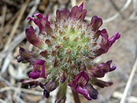 Astragalus troglodytus |
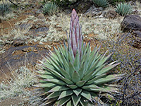 Agave parryi |
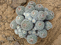 Escobaria vivipara |
 Frasera albomarginata |
More flowers along the trail
Casner Canyon - Similar Hikes
All Contents © Copyright The American Southwest | Comments and Questions | Contribute | Affiliate Marketing Disclosure | Site Map