Broken Arrow Trail
#125
#125
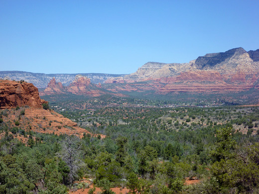
Quick route into the red rock landscape south of Sedona, climbing gradually to a slickrock pass (Chicken Point), giving good, elevated views over the surroundings
Length: 1.5 miles
Elevation change: 300 feet
Difficulty: Easy
Type: One way. Links with the Little Horse Trail, leading to an alternative start point
Usage: High
Season: All year
Trailhead: Parking area at the end of Morgan Road
Rating (1-5): ★★★★★
Elevation change: 300 feet
Difficulty: Easy
Type: One way. Links with the Little Horse Trail, leading to an alternative start point
Usage: High
Season: All year
Trailhead: Parking area at the end of Morgan Road
Rating (1-5): ★★★★★

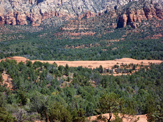
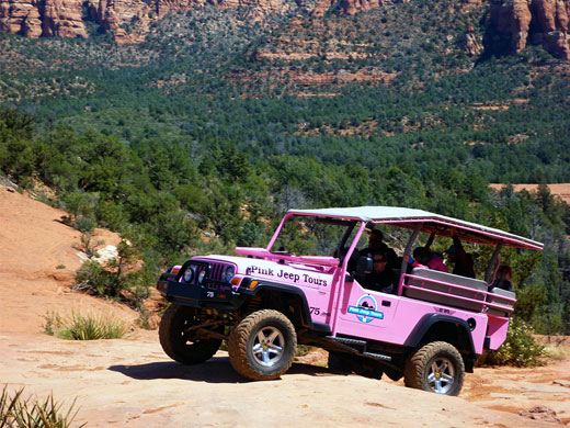
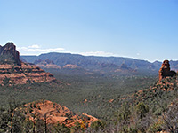
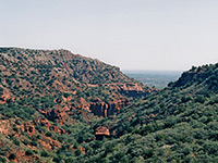
Because of its easily reached location on the south side of Sedona, just off Hwy 179, the Broken Arrow Trail is one of the busiest short hikes in the area, and runs close to a jeep track that is also very popular. Both routes climb gently up a wide valley, lined on both sides by colorful, jagged, eroded red cliffs and buttes, ending at a low pass (Chicken Point), which has good views south towards Oak Creek village, and north to Sedona and the high mountains beyond.
From the pass, the Little Horse Trail continues southwards to an alternative starting point though most is over flat, bushy land, so the northern path is preferred. The Broken Arrow Trail is also used by cyclists; together with the large number of people and the nearby jeeps, the trip is not for hikers seeking solitude but it does offer a good introduction to Sedona's famous red rock scenery, and the trailhead is close enough to some nearby hotels for residents to reach without driving.
Broken Arrow Trail topographic map, Sedona location map.
15 views along the Broken Arrow Trail.
The trailhead is reached via Morgan Road, a short residential street that is also used by dozens of pink jeeps and similar vehicles each day, this being one of Sedona's main 4WD tour locations. Parking for hikers is a smallish area beside the start of the jeep road, which follows close to the path much of the way though stays largely out of sight. The popularity of the trail is somewhat limited by the size of the parking area though many people can walk in from town. The 2 mile Margs Draw Trail also begins here, heading north towards Schnebly Hill Road. The standard $5 Red Rock Pass is required for all parked vehicles.
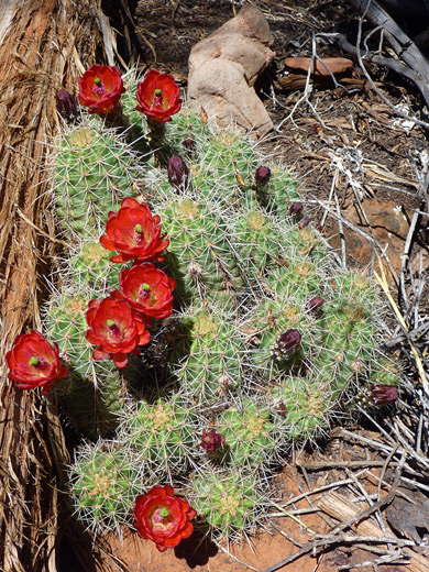
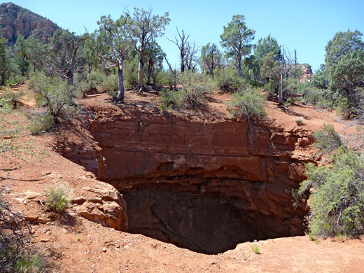
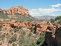
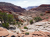
All the trail is wide, easy to follow and well used, marked by large cairns where it crosses rocky patches. Plants in this region include several species of yucca and agave, echinocereus triglochidiatus with its showy crimson flowers, the large-padded opuntia phaeacantha, juniper, pinyon pine and Arizona cypress, characterized by thin, peeling, grey-brown bark. The path begins on the south side of the jeep track, initially along the base of a big sandstone butte, then crosses some slickrock either side of a minor drainage. The next section rounds the end of a spur in the jeep road to the Devil's Dining Room, a sinkhole caused by collapse of a cavern in the underlying redwall limestone, exposing Schnebly Hill sandstone and hermit shale near the rim of the hole, which is 60 to 90 feet deep and fenced off for safety.
ASoon after, a branch in the path forks east to Submarine Rock, a long, flat, narrow sandstone outcrop rising a little way above the surrounding bushy land, with two small summits at each end. The main path continues climbing gently, close to an overgrown ravine then over undulating sandstone slopes, an area crossed by the jeeps, resulting in wide, black tire marks in many places. The last ascent leads to the pass at Chicken Point, also the final destination for the jeeps; from here the Little Horse Trail descends back to the highway, nearly all through wooded surroundings with limited views. Another short path (Chapel Trail) branches off and ends at a parking area near the Chapel of the Holy Cross.
From the pass, the Little Horse Trail continues southwards to an alternative starting point though most is over flat, bushy land, so the northern path is preferred. The Broken Arrow Trail is also used by cyclists; together with the large number of people and the nearby jeeps, the trip is not for hikers seeking solitude but it does offer a good introduction to Sedona's famous red rock scenery, and the trailhead is close enough to some nearby hotels for residents to reach without driving.
Maps
Broken Arrow Trail topographic map, Sedona location map.
Photographs
15 views along the Broken Arrow Trail.
Broken Arrow Trailhead
The trailhead is reached via Morgan Road, a short residential street that is also used by dozens of pink jeeps and similar vehicles each day, this being one of Sedona's main 4WD tour locations. Parking for hikers is a smallish area beside the start of the jeep road, which follows close to the path much of the way though stays largely out of sight. The popularity of the trail is somewhat limited by the size of the parking area though many people can walk in from town. The 2 mile Margs Draw Trail also begins here, heading north towards Schnebly Hill Road. The standard $5 Red Rock Pass is required for all parked vehicles.
The Path
All the trail is wide, easy to follow and well used, marked by large cairns where it crosses rocky patches. Plants in this region include several species of yucca and agave, echinocereus triglochidiatus with its showy crimson flowers, the large-padded opuntia phaeacantha, juniper, pinyon pine and Arizona cypress, characterized by thin, peeling, grey-brown bark. The path begins on the south side of the jeep track, initially along the base of a big sandstone butte, then crosses some slickrock either side of a minor drainage. The next section rounds the end of a spur in the jeep road to the Devil's Dining Room, a sinkhole caused by collapse of a cavern in the underlying redwall limestone, exposing Schnebly Hill sandstone and hermit shale near the rim of the hole, which is 60 to 90 feet deep and fenced off for safety.
Submarine Rock
ASoon after, a branch in the path forks east to Submarine Rock, a long, flat, narrow sandstone outcrop rising a little way above the surrounding bushy land, with two small summits at each end. The main path continues climbing gently, close to an overgrown ravine then over undulating sandstone slopes, an area crossed by the jeeps, resulting in wide, black tire marks in many places. The last ascent leads to the pass at Chicken Point, also the final destination for the jeeps; from here the Little Horse Trail descends back to the highway, nearly all through wooded surroundings with limited views. Another short path (Chapel Trail) branches off and ends at a parking area near the Chapel of the Holy Cross.
Broken Arrow Trail - Similar Hikes
All Contents © Copyright The American Southwest | Comments and Questions | Contribute | Affiliate Marketing Disclosure | Site Map