Upper Canyon and Haynes Ridge Overlook Trails, Caprock Canyons State Park
Texas > Caprock Canyons State Park > Upper Canyon and Haynes Ridge Overlook Trails
Upper Canyon and Haynes Ridge Overlook Trails
Circular route up a narrowing canyon to a cool, sheltered grotto (Fern Cave), followed by a steep climb to the top of the plateau, a traverse of open country and a sharp descent back to the trailhead; varied scenery, and good views
Length: 7 miles round trip
Elevation change: 650 feet
Difficulty: Moderate
Type: Loop. Alternative return is via the continuation of the Upper Canyon Trail
Usage: Medium
Season: All year, though summers are hot
Trailhead: Parking area near North Prong Primitive Campground
Rating (1-5): ★★★★★
Elevation change: 650 feet
Difficulty: Moderate
Type: Loop. Alternative return is via the continuation of the Upper Canyon Trail
Usage: Medium
Season: All year, though summers are hot
Trailhead: Parking area near North Prong Primitive Campground
Rating (1-5): ★★★★★

The Upper Canyon Trail is a loop hike with two trailheads; one is at the far end of the Caprock Canyons park drive at the South Prong campground, and the other is a mile back along the road, at a parking area also used to reach the North Prong primitive camp site. This hike is good enough but 90% is either beneath the cliffs or along canyons so the views are somewhat limited. A more varied trip is to walk one half of the loop and return via the Haynes Ridge Overlook Trail, which runs for 2 miles on top of the escarpment so has much better views. This is the hike described below, starting from the North Prong parking area.
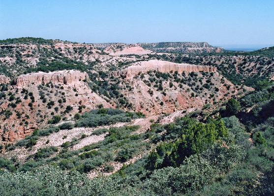
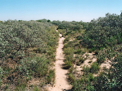
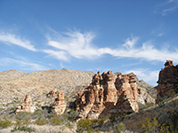
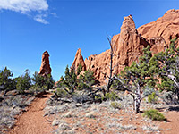
The straight trail sets off to the north, running parallel to the eroded red cliff face that rises several hundred feet just to the east. The nearby land is undulating and bushy, formed of small red/white hills bearing yucca and cacti, most visibly two species of opuntia (tree cholla and pencil cholla). The first mile or so is quite wide and level, as this part is driven by park rangers in ATVs, who leave drinking water at several places if the weather is hot, though all this section is easy, with a few short rises and descents but mostly flat. The path passes washes and canyons, buttes, spires and hoodoos, though all formations are on a small scale, then it rounds a bend in the cliffs and follows a wider wash upstream, that gradually narrows and deepens until it forms a proper canyon, contained within vertical walls at each side. The trail is then in the streambed some of the time but mostly above, on the left side, often through quite thick undergrowth.
After about a mile of relatively confined hiking, the canyon narrows abruptly beneath a 30 foot drop off, where the path turns left and begins its 600 foot ascent to the top of the adjacent ridge. A short spur leads down to the base of the falls, a place known as Fern Cave, where dripping water and overhanging rocks have created a cool, fern-lined grotto, permanently sheltered from the sun. A small stream emerges from a V-shaped slot above and forms a few shallow pools amongst the boulders on the floor of the grotto, which is a nice place to rest on a hot day, and source of good tasting drinking water.
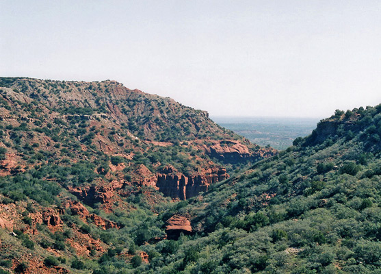
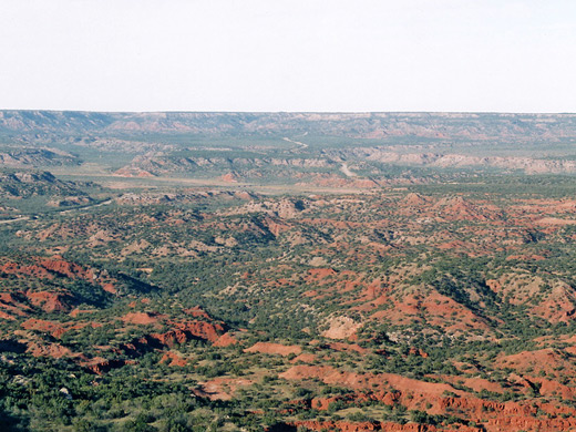
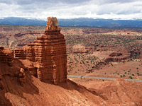
The main trail climbs steeply via switchbacks to the top of the plateau, at this point actually a narrow ridge between two canyons. Not many people climb all the way to the top and the whole scene is very peaceful and remote, only slightly spoilt by occasional traffic on road TX 256 that runs just 1/4 mile to the north. The trail soon forks, 4.2 miles from the start; right is the continuation of the Upper Canyon Trail, dropping down the side of the next valley and meeting the park road again after another 2.5 miles. The left fork is the Haynes Ridge Overlook Trail, that winds over the flat ridge separating the two canyons - level, open land covered by short bushes growing on the whitish limestone soil of the caprock formation. The views get gradually better as the ridge narrows, until the final overlook from where a full 270° of the horizon is visible, comprising a large area of red rock canyons and cliffs, and many miles of flatter, greener land to the south. The path finishes by descending 400 feet, steeply in places and over sections with loose rocks, before joining the Upper Canyon Trail one mile from the North Prong trailhead. The best two places on this trip are definitely Fern Cave and the overlook, and the 7 mile round trip takes from 3 to 6 hours.
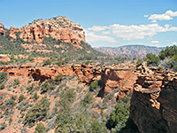
Start of the Trail
The straight trail sets off to the north, running parallel to the eroded red cliff face that rises several hundred feet just to the east. The nearby land is undulating and bushy, formed of small red/white hills bearing yucca and cacti, most visibly two species of opuntia (tree cholla and pencil cholla). The first mile or so is quite wide and level, as this part is driven by park rangers in ATVs, who leave drinking water at several places if the weather is hot, though all this section is easy, with a few short rises and descents but mostly flat. The path passes washes and canyons, buttes, spires and hoodoos, though all formations are on a small scale, then it rounds a bend in the cliffs and follows a wider wash upstream, that gradually narrows and deepens until it forms a proper canyon, contained within vertical walls at each side. The trail is then in the streambed some of the time but mostly above, on the left side, often through quite thick undergrowth.
Fern Cave
After about a mile of relatively confined hiking, the canyon narrows abruptly beneath a 30 foot drop off, where the path turns left and begins its 600 foot ascent to the top of the adjacent ridge. A short spur leads down to the base of the falls, a place known as Fern Cave, where dripping water and overhanging rocks have created a cool, fern-lined grotto, permanently sheltered from the sun. A small stream emerges from a V-shaped slot above and forms a few shallow pools amongst the boulders on the floor of the grotto, which is a nice place to rest on a hot day, and source of good tasting drinking water.
Haynes Ridge
The main trail climbs steeply via switchbacks to the top of the plateau, at this point actually a narrow ridge between two canyons. Not many people climb all the way to the top and the whole scene is very peaceful and remote, only slightly spoilt by occasional traffic on road TX 256 that runs just 1/4 mile to the north. The trail soon forks, 4.2 miles from the start; right is the continuation of the Upper Canyon Trail, dropping down the side of the next valley and meeting the park road again after another 2.5 miles. The left fork is the Haynes Ridge Overlook Trail, that winds over the flat ridge separating the two canyons - level, open land covered by short bushes growing on the whitish limestone soil of the caprock formation. The views get gradually better as the ridge narrows, until the final overlook from where a full 270° of the horizon is visible, comprising a large area of red rock canyons and cliffs, and many miles of flatter, greener land to the south. The path finishes by descending 400 feet, steeply in places and over sections with loose rocks, before joining the Upper Canyon Trail one mile from the North Prong trailhead. The best two places on this trip are definitely Fern Cave and the overlook, and the 7 mile round trip takes from 3 to 6 hours.
Upper Canyon and Haynes Ridge Overlook - Similar Hikes
All Contents © Copyright The American Southwest | Comments and Questions | Contribute | Affiliate Marketing Disclosure | Site Map