Munds Canyon
Off trail route across a forested plateau and into the upper end of a boulder-filled, basalt-walled gorge containing a permanent stream
Length: 2+ miles
Elevation change: 500+ feet
Difficulty: Moderate
Type: One way, cross country
Usage: Low
Season: Late spring to early winter, as the canyon is affected by snow and high water levels at other times
Trailhead: West side of I-17, exit 322
Rating (1-5): ★★★★★
Elevation change: 500+ feet
Difficulty: Moderate
Type: One way, cross country
Usage: Low
Season: Late spring to early winter, as the canyon is affected by snow and high water levels at other times
Trailhead: West side of I-17, exit 322
Rating (1-5): ★★★★★

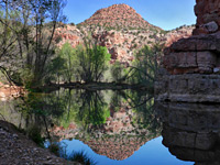
Munds Canyon is the largest tributary of Oak Creek Canyon, joining the main valley 5 miles north of Sedona; the confluence is near Indian Gardens, a small village set in woodland near the creek, and the lower end of the canyon is privately owned. There is a trail that climbs 1,500 feet to Thompson's Point, an overlook between Munds and the adjacent Bee Canyon, with views over a large section of the surrounding cliffs and south towards the town, but apart from this exploration is best started from the upper end of the canyon, accessed from I-17.
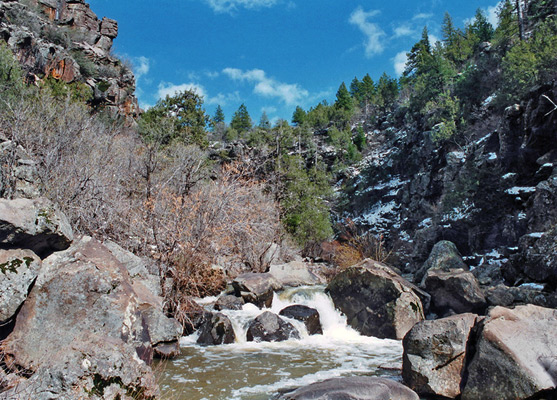
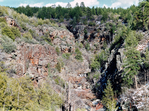
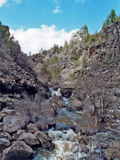
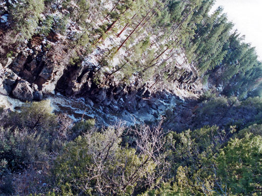
Water from melting snow flows through the canyon in spring and early summer, while at other times it is much drier, although with some deep pools that remain all year. The character of the gorge changes considerably over the 6 miles from start to finish; it begins at the edge of Munds Park - a flat area with meadows and several small lakes, surrounded by the densely-growing pine trees of the Coconino National Forest. The land rises a little towards the southwest, and streams from the meadows flow in this direction, into the upper end of the canyon which remains 100 - 200 feet deep for a couple of miles.
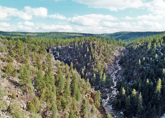
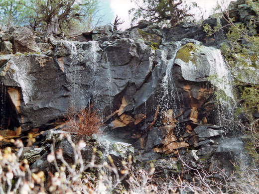
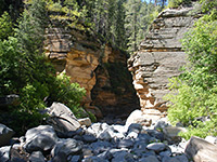
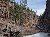
The walls are quite steep, composed of dark basalt boulders and are rather overgrown with trees and bushes, but become more vertical in places after a while, from the point where the streamway begins to cut into the underlying Kaibab limestone. More extensive pools may be found from now on. Deepening continues through the next layer, Toroweap sandstone, and the gorge, by now 400 feet deep, turns due north. A sizeable tributary joins from the south and the canyon becomes wider, deeper still, more impressive and a little easier to traverse. High cliffs of Coconino sandstone appear, and from here to the end the scenery is similar to the main Oak Creek Canyon, north of Sedona. There are a few small waterfalls and several lesser tributaries which have powerful cascades in spring.
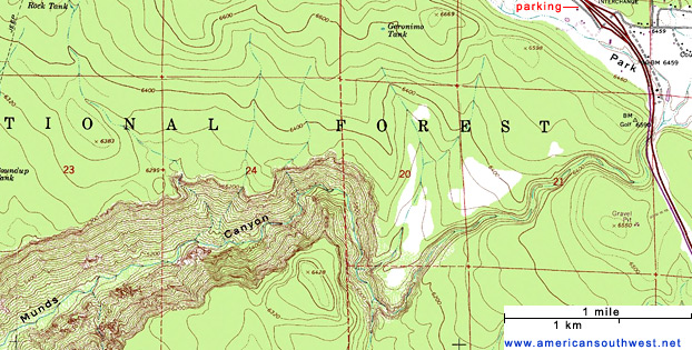
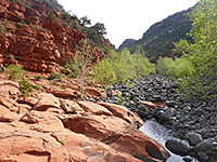
I-17 crosses the very top of Munds Canyon just south of exit 322 but land in the vicinity is privately owned. The best approach is to park along a spur road on the west side of the exit, walk across the adjacent fields into the woodland then head up a ridge and continue due south across flattish ground that descends after about half a mile to the canyon. In summer at least it is easy to climb down, then the hike simply involves following the streambed, with occasional scrambling and boulder-hopping required to bypass pools and short falls. In spring however, when snow still lies in the forest, the cold, fast-flowing stream may be too deep to wade, so following the canyon is quite difficult as in places the water covers all of the area between the walls. The ravine has some pretty sections - occasional steep, eroded cliffs, pools and cascades - but is generally not especially interesting. Following at rim level is another option; the land at the top (north side) is quite flat, open and stony, and despite the high elevation and low winter temperatures, supports many clumps of mammillaria cacti. Walking is easy, and the rim can be followed for as far as desired; one good target is a promontory that overlooks the middle part of the canyon, near to a junction with a tributary from the south.
The Canyon
Water from melting snow flows through the canyon in spring and early summer, while at other times it is much drier, although with some deep pools that remain all year. The character of the gorge changes considerably over the 6 miles from start to finish; it begins at the edge of Munds Park - a flat area with meadows and several small lakes, surrounded by the densely-growing pine trees of the Coconino National Forest. The land rises a little towards the southwest, and streams from the meadows flow in this direction, into the upper end of the canyon which remains 100 - 200 feet deep for a couple of miles.
Cliffs
The walls are quite steep, composed of dark basalt boulders and are rather overgrown with trees and bushes, but become more vertical in places after a while, from the point where the streamway begins to cut into the underlying Kaibab limestone. More extensive pools may be found from now on. Deepening continues through the next layer, Toroweap sandstone, and the gorge, by now 400 feet deep, turns due north. A sizeable tributary joins from the south and the canyon becomes wider, deeper still, more impressive and a little easier to traverse. High cliffs of Coconino sandstone appear, and from here to the end the scenery is similar to the main Oak Creek Canyon, north of Sedona. There are a few small waterfalls and several lesser tributaries which have powerful cascades in spring.
Exploring Munds Canyon
I-17 crosses the very top of Munds Canyon just south of exit 322 but land in the vicinity is privately owned. The best approach is to park along a spur road on the west side of the exit, walk across the adjacent fields into the woodland then head up a ridge and continue due south across flattish ground that descends after about half a mile to the canyon. In summer at least it is easy to climb down, then the hike simply involves following the streambed, with occasional scrambling and boulder-hopping required to bypass pools and short falls. In spring however, when snow still lies in the forest, the cold, fast-flowing stream may be too deep to wade, so following the canyon is quite difficult as in places the water covers all of the area between the walls. The ravine has some pretty sections - occasional steep, eroded cliffs, pools and cascades - but is generally not especially interesting. Following at rim level is another option; the land at the top (north side) is quite flat, open and stony, and despite the high elevation and low winter temperatures, supports many clumps of mammillaria cacti. Walking is easy, and the rim can be followed for as far as desired; one good target is a promontory that overlooks the middle part of the canyon, near to a junction with a tributary from the south.
Topographic Map of Munds Canyon
Munds Canyon - Similar Hikes
All Contents © Copyright The American Southwest | Comments and Questions | Contribute | Affiliate Marketing Disclosure | Site Map