Sycamore Falls Loop
Off-trail loop along the upper end of the west fork of Sycamore Canyon, also passing a crater on the rim. Descending via a steep, bouldery side drainage and climbing up the north fork of Sycamore Falls
Length: 2 miles (round trip)
Elevation change: 400 feet
Difficulty: Strenuous - climbing, scrambling
Type: Loop
Usage: Low
Season: Spring, summer, fall - affected by snow in the winter
Trailhead: Along a good quality dirt track, 11.3 miles from Interstate 40
Rating (1-5): ★★★★★
Elevation change: 400 feet
Difficulty: Strenuous - climbing, scrambling
Type: Loop
Usage: Low
Season: Spring, summer, fall - affected by snow in the winter
Trailhead: Along a good quality dirt track, 11.3 miles from Interstate 40
Rating (1-5): ★★★★★

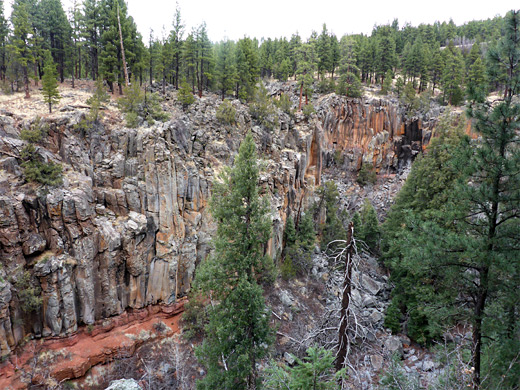
Towards its upper end Sycamore Canyon splits into two branches each about two miles long, and the western fork itself divides to a pair of much shorter ravines (700 feet), both of which begin via a vertical pour-off, known collectively as Sycamore Falls, or Paradise Forks.
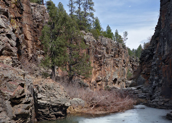
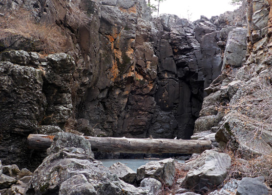
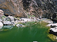
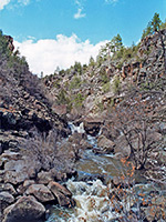
Downstream, the cliffs stay vertical for another few hundred feet, and this section is a popular place for technical rock climbing, with ropes, however the north fork at least can be entered unassisted, right at the upper end, climbing down around 50 feet to the rocky creek bed which often contains a big pool, permanently frozen for several months in winter and spring. The initial falls in the south fork may also be descended though here the ravine soon drops again, more sharply, and this obstacle cannot readily be free-climbed. But once down the northern falls there are no other significant obstructions all the way downstream.
One option for a short loop hike, described below, is to walk through the pine forest along the southern rim of the canyon, past a small crater, then descend a boulder-filled ravine to the main canyon floor and head back upstream, exiting via the northern falls. The loop is possible most of the year, just not in winter because of the snow, and perhaps not in late spring once the ice in the pool has melted yet the water remains quite deep. The canyon holds flowing water only during the peak snowmelt season and for a short time after heavy rainfall.
Sycamore Canyon overview map, Sycamore Falls topographic map.
22 views along the loop.
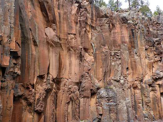
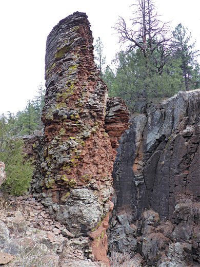
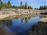
The Sycamore Falls trailhead, also used for hikes along the Sycamore Rim Trail, is 11.3 miles from Interstate 40 along good quality dirt tracks through the tall trees of the Coconino National Forest. From here a path leads down a slope and crosses the drainage just upstream of the northern falls; the south fork is 600 feet away, over a little ridge. The cliffs of this branch (directly from the streambed) offer a fairly obvious route down, via big rock steps and on a little way to the edge of a pool, the waters of which may cover all of the floor up to the walls at either side, or be rather less extensive. In spring, when still solidly frozen, there is no problem walking across, and continuing over a few boulders to brink of the narrow drop into the lower pool (known as the Gold Pond), which is less likely to be frozen. Like the north fork, the southern branch is enclosed by richly-colored basalt, the upper component of which is fairly homogenous, with a coarse-grained texture, while the thicker lower part contains smoother rock, split into vertical columns.
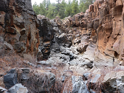
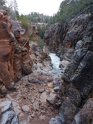
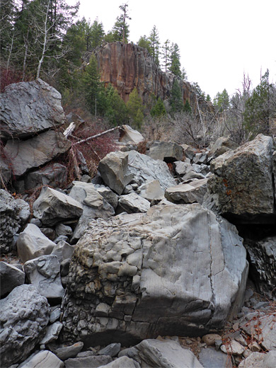
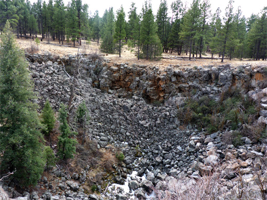
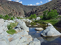
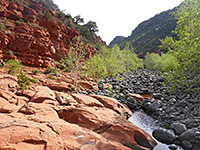
Back on the rim, a faint path follows the south edge of Sycamore Canyon for a while then fades away, crossing wooded and sometimes quite overgrown land that later rises to a flatter area, mostly treeless. Not far ahead is a circular crater, presumably a volcanic remnant, 220 feet across, its north edge separated from the canyon by just a narrow strip of rock. The land stays flat beyond for a quarter of a mile before descending gently into a tree-lined bowl, containing a tiny drainage which once over the rim falls away very steeply over many big boulders. Flood debris shows that on rare occasions the ravine holds a forceful stream. The upper part is quite bushy, the lower reaches less overgrown. Towards the lower end is a minor drop-off after which the undergrowth increases, approaching the canyon floor. Like most of Sycamore Canyon, the creekbed contains innumerable huge, jumbled boulders of grey and red rocks, a mix of lava and sandstone, but walking upstream (or downstream) offers no great problems, since periodic cleansing by powerful floods keeps the streamway largely free of vegetation. The confluence of the two upper forks is reached after about twenty minutes of walking, round two slight bends. The north fork gradually narrows, becoming briefly like a slot canyon, confined by dark, vertical walls, and its upper end contains another sizeable pool. The easiest climbing route out is on the north side just 70 feet or so before the actual fall, ascending the basalt walls via steps then a short crevice.
Downstream, the cliffs stay vertical for another few hundred feet, and this section is a popular place for technical rock climbing, with ropes, however the north fork at least can be entered unassisted, right at the upper end, climbing down around 50 feet to the rocky creek bed which often contains a big pool, permanently frozen for several months in winter and spring. The initial falls in the south fork may also be descended though here the ravine soon drops again, more sharply, and this obstacle cannot readily be free-climbed. But once down the northern falls there are no other significant obstructions all the way downstream.
One option for a short loop hike, described below, is to walk through the pine forest along the southern rim of the canyon, past a small crater, then descend a boulder-filled ravine to the main canyon floor and head back upstream, exiting via the northern falls. The loop is possible most of the year, just not in winter because of the snow, and perhaps not in late spring once the ice in the pool has melted yet the water remains quite deep. The canyon holds flowing water only during the peak snowmelt season and for a short time after heavy rainfall.
Maps
Sycamore Canyon overview map, Sycamore Falls topographic map.
Photographs
22 views along the loop.
South Fork of the Canyon
The Sycamore Falls trailhead, also used for hikes along the Sycamore Rim Trail, is 11.3 miles from Interstate 40 along good quality dirt tracks through the tall trees of the Coconino National Forest. From here a path leads down a slope and crosses the drainage just upstream of the northern falls; the south fork is 600 feet away, over a little ridge. The cliffs of this branch (directly from the streambed) offer a fairly obvious route down, via big rock steps and on a little way to the edge of a pool, the waters of which may cover all of the floor up to the walls at either side, or be rather less extensive. In spring, when still solidly frozen, there is no problem walking across, and continuing over a few boulders to brink of the narrow drop into the lower pool (known as the Gold Pond), which is less likely to be frozen. Like the north fork, the southern branch is enclosed by richly-colored basalt, the upper component of which is fairly homogenous, with a coarse-grained texture, while the thicker lower part contains smoother rock, split into vertical columns.

Pomeroy Tanks
Back on the rim, a faint path follows the south edge of Sycamore Canyon for a while then fades away, crossing wooded and sometimes quite overgrown land that later rises to a flatter area, mostly treeless. Not far ahead is a circular crater, presumably a volcanic remnant, 220 feet across, its north edge separated from the canyon by just a narrow strip of rock. The land stays flat beyond for a quarter of a mile before descending gently into a tree-lined bowl, containing a tiny drainage which once over the rim falls away very steeply over many big boulders. Flood debris shows that on rare occasions the ravine holds a forceful stream. The upper part is quite bushy, the lower reaches less overgrown. Towards the lower end is a minor drop-off after which the undergrowth increases, approaching the canyon floor. Like most of Sycamore Canyon, the creekbed contains innumerable huge, jumbled boulders of grey and red rocks, a mix of lava and sandstone, but walking upstream (or downstream) offers no great problems, since periodic cleansing by powerful floods keeps the streamway largely free of vegetation. The confluence of the two upper forks is reached after about twenty minutes of walking, round two slight bends. The north fork gradually narrows, becoming briefly like a slot canyon, confined by dark, vertical walls, and its upper end contains another sizeable pool. The easiest climbing route out is on the north side just 70 feet or so before the actual fall, ascending the basalt walls via steps then a short crevice.

Sycamore Falls Loop - Similar Hikes
All Contents © Copyright The American Southwest | Comments and Questions | Contribute | Affiliate Marketing Disclosure | Site Map