Highlights:
A narrow canyon which leads to a wider, deeper gorge containing a warm spring, and then to the permanent stream of Burro Creek, which forms deep pools in springtime. All around are steep, volcanic rocks bearing many cacti
Nearby town:
Wickenburg, 62 miles
Management:
BLM
Location:
Seasons:
Winter, spring and fall; summers are rather hot
Rating (1-5):
★★★★★

There are few obvious attractions in west central Arizona, and most of the land is quite inaccessible since only one highway passes through - this is the busy US 93 from Phoenix to Kingman and Las Vegas, but apart from this and a few unpaved side roads, most of the surroundings are pathless desert.
To the east, the land gradually rises to the mountains of the Prescott National Forest and the Mogollon Rim, while to the west are large expanses of cactus covered hills and, at the lowest elevations, barren desert plains, but one feature common to the whole area are canyons, and the best of the few easily reached from US 93 is Kaiser Spring Canyon, 62 miles northwest of Wickenburg.
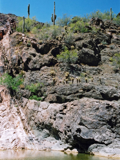
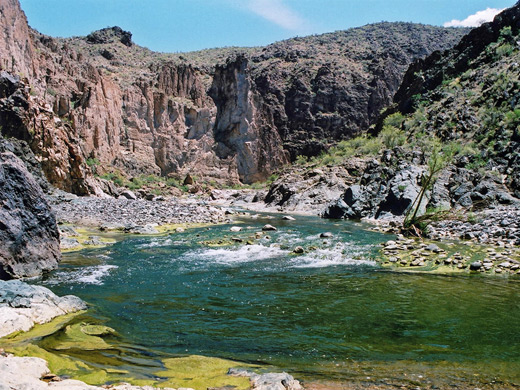
The canyon is quite a long drainage that passes under the highway near its lower end. Just east of the road is a deep though short slot canyon section while at the other side is a typical desert ravine dotted with saguaro cacti, and containing a warm spring. The ravine then meets the larger canyon formed by Burro Creek, which in springtime carries a high flow of water, creating beautiful pools and cascades.
To the east, the land gradually rises to the mountains of the Prescott National Forest and the Mogollon Rim, while to the west are large expanses of cactus covered hills and, at the lowest elevations, barren desert plains, but one feature common to the whole area are canyons, and the best of the few easily reached from US 93 is Kaiser Spring Canyon, 62 miles northwest of Wickenburg.
The canyon is quite a long drainage that passes under the highway near its lower end. Just east of the road is a deep though short slot canyon section while at the other side is a typical desert ravine dotted with saguaro cacti, and containing a warm spring. The ravine then meets the larger canyon formed by Burro Creek, which in springtime carries a high flow of water, creating beautiful pools and cascades.
Kaiser Spring Canyon Table of Contents
- Photographs
- Location
- Upstream - Kaiser Spring Canyon
- Downstream - Warm Spring Canyon
- Burro Creek
- Nearby places
- Similar places
Photographs
15 views of Kaiser Spring Canyon and Burro Creek.
Location
Kaiser Spring Canyon is not signposted but easily located using a map. The highway crosses the canyon via a high, twin-laned bridge, north of which are two routes down to the streamway. The first is just after the bridge on the east side, where a track descends a little then forks; main branch is to the left, a short road that heads into the hills and generally away from the canyon, while the other soon ends in a parking area directly below the road bridge. The second access route is to the west, half a mile from the bridge, and is recommended for 4WD only; this is a rougher track that follows a side valley to the canyon floor.
Upstream - Kaiser Spring Canyon
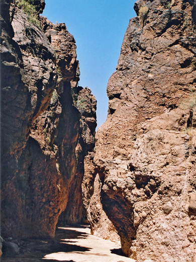
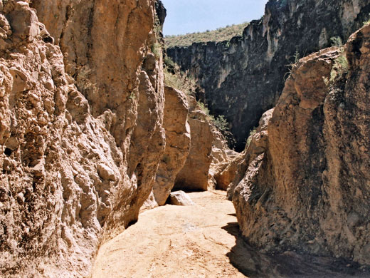
From a parking area a short distance along the east side approach road, the view southwards is of mostly rounded hills bearing some saguaro, backed by the tops of higher, rockier peaks in the distance. Beneath the highway, the canyon walls are gently sloping, allowing easy entry, but they come together after a 5 minute walk upstream, framing a section of slot-like narrows which though fully enclosed is never less than 5 meters across. The canyon floor is flat and sandy apart from a few channels of polished rock, whilst above rise dark, vertical cliffs, jagged and weathered, and higher up harboring saguaro and other cacti. This part of the canyon doesn't stay narrow for long, becoming less sheer and more open, but it is quite attractive. The narrowest section begins just below some powerlines that cross the canyon, less then half a mile from the highway.
Downstream - Warm Spring Canyon
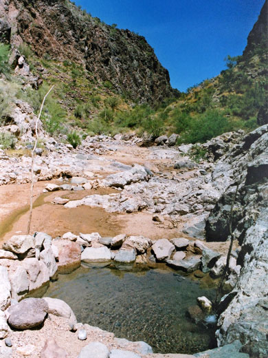
Downstream (southwest), the wash now known as Warm Spring Canyon enters a straightish, sandy section then bends west and is joined by a side valley, along which runs the alternative access jeep track. This follows the wash at stream level for a while, around quite a tight bend, though this part is disused. The warm spring is not far beyond, emerging from the rocks on the left side a few feet above the canyon floor, and flowing into a constructed pool half a meter deep, just big enough for three people to paddle in. The hike to this point is easy, and good for a family trip though all this area is unsuitable for summer exploration owing to the low elevations and high temperatures.
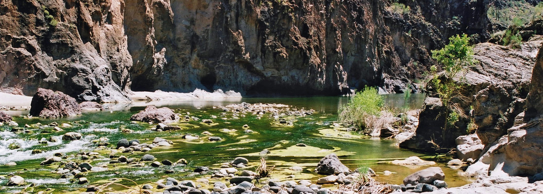
Burro Creek
Around the next bend, Warm Spring Canyon meets the larger ravine of Burro Creek, which in springtime is quite a forceful river that is still easy to cross in certain places but deep and fast flowing in others. Upstream are three large pools, the middle one many feet deep and maybe 150 feet long, set beneath high, dark, basalt cliffs, in some places rising sheer from the water, in others more stepped and bearing various cacti, all creating quite an impressive scene. Four large boulders form mini islands in the greenish waters, and there are plenty of sandy beaches at either side. Further upstream, and below the junction with Warm Spring Canyon, the ravine is less sheer and contains more rocks in the streambed.
Kaiser Spring Canyon - Nearby Places
- Alamo Lake State Park (20 miles direct, though 120 miles by road) - desert mountains, and a lake
- Black Canyon (4 miles) - ravine through lava, containing a small stream
Kaiser Spring Canyon - Similar Places
- Fish Creek - rocky canyon in the Superstition Mountains
- Tonto Creek - beautiful desert stream
- Bill Williams River Canyon - ravine through the Rawhide Mountains
All Contents © Copyright The American Southwest | Comments and Questions | Contribute | Affiliate Marketing Disclosure | Site Map