Mammoth Terraces, Yellowstone National Park
Wyoming > Yellowstone National Park > The North > Hiking > Mammoth Terraces
Mammoth Terraces
The terraces, pools and dormant thermal features of Mammoth Hot Springs; the lower section is viewed by a series of short, interconnected loop trails, while the more overgrown, less visited upper section is crossed by a narrow, one-way road, also suitable for hiking
Length: 1 mile (loop) for the lower section, or 2.8 miles (loop) for all areas
Elevation change: 220 feet, 520 feet
Difficulty: Easy
Type: Loop hikes
Usage: High, low to medium
Season: All year
Trailhead: Parking area along the main road (US 89)
Rating (1-5): ★★★★★
Elevation change: 220 feet, 520 feet
Difficulty: Easy
Type: Loop hikes
Usage: High, low to medium
Season: All year
Trailhead: Parking area along the main road (US 89)
Rating (1-5): ★★★★★

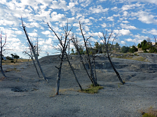
The thermal features of Mammoth Hot Springs have decreased in activity in recent years, and areas formally wet and lined by colorful algae are now dry, and white or grey, yet enough remains for this still to be one of the highlights of Yellowstone National Park.
Mammoth is most famous for its travertine terraces - numerous tiny, shallow pools along ledges of many different levels - though it also has a variety of hot springs and gas vents, divided approximately into two halves; the lower, or main terraces, toured by several short loop trails, and the upper or highland terraces, circled by a narrow, one-way drive, closed to RVs and other large vehicles.
The lower Mammoth terraces are usually very busy, in part due to the easy access from the main road, yet the upper region is much quieter, and despite the regular though infrequent traffic on the road, this is also a good hiking destination. The distance of all the trails across the lower terrace is about one mile, and when combined with the walk along the upper road the total is 2.8 miles, passing several dozen named thermal features.
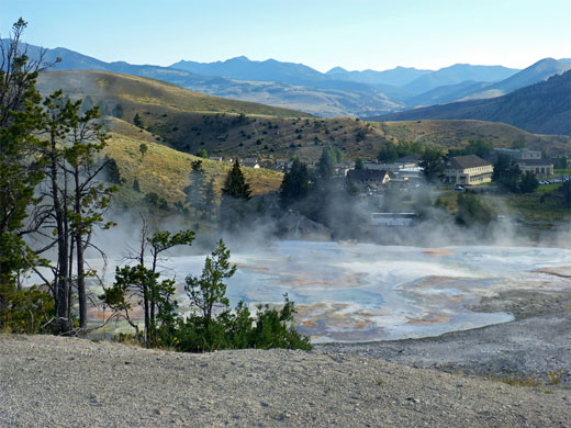
The lower basin is generally unvegetated, and the various terraces are part of a continuous mineralized area about a third of a mile cross, while the higher regions are partly wooded, the springs and terraces separated by grassy patches and groups of trees. Most areas have far-reaching views north, across Mammoth towards the Yellowstone River canyon, and there is a good chance of spotting wildlife, especially elk, who often wander across the treeless flats.
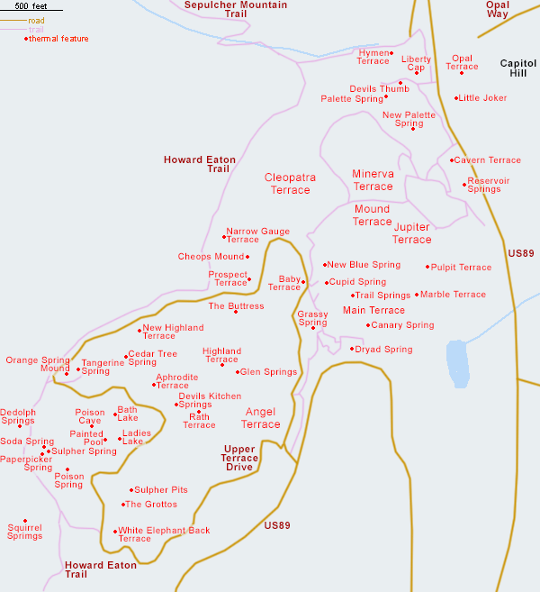
Map of the Mammoth Terraces
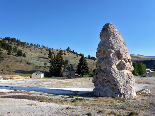
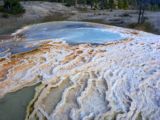
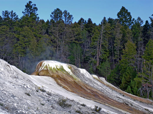
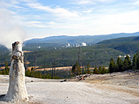
There are several parking places along the main road near the Lower Terraces, and if full there is usually space along Opal Way, a dead-end side street on the east side of the highway. The northernmost thermal feature is Hymen Terrace along the south bank of Clematis Creek, viewed from the lower end of the trail to Beaver Ponds and Sepulcher Mountain; also in the vicinity is Liberty Cap, a 40 foot high travertine cone from a long extinct spring. South of here is the first trail into the terraces, formerly a loop, though recent thermal activity has blocked the upper end, turning it into a 400 foot long spur, passing beneath the currently most colorful terrace, formed by Palette Spring - an elongated array of little pools and trickling water, sprinkled with a few dead trees. Run-off from the spring has partially enveloped Devils Thumb, another grey geyserite cone, rather smaller than Liberty Cap. Close by, at slightly higher elevation, is New Palette Spring, viewed from the next trail south.
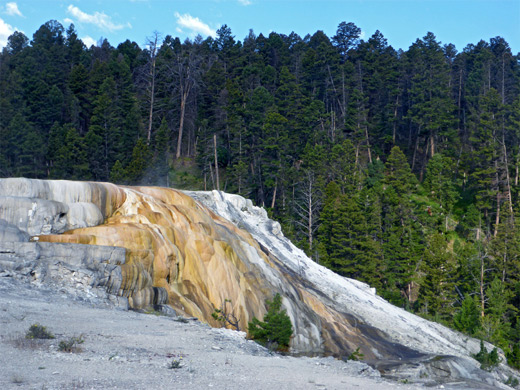
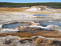
The next path southwards leaves the road beside the dormant Cavern Terrace and loops all around Minerva Terrace, a formerly large and colorful structure but now nearly all grey and dry. On the far side, slightly off-trail and close to the edge of the forest, is Cleopatra Terrace, a sizeable area of yellow and orange flow formations. Jupiter Terrace, on the south side of the loop, is also generally inactive, but adjacent Mound Terrace is a little more colorful. Another trail climbs a gentle slope and intersects the upper terrace drive, past a few minor pools (one, New Blue Spring may be dry, or filled with hot, bluish water) and on to Canary Spring at the south edge of the Main Terrace, which again, apart from the spring and a few other areas, is mostly dull-colored.
Walking counter-clockwise along the road from the lower terrace link path, the first significant formation is Narrow Gauge Terrace, a long, thin, whitish ridge which is most active towards its far end. This is closely followed by Cheops Mound and the dormant Prospect Terrace and then, on the south side of the road, the pretty New Highland Terrace, a mostly white formation about 300 feet long, with a few stark dead trees along the front. After a brief wooded patch, the road curves round Orange Spring Mound, a prominent travertine hill with an active orange area on the west side, and the similarly colored Tangerine Spring to the east; it then continues to the pure white Aphrodite Terrace. On the opposite side of the drive is Bath Lake, occasionally a sizeable warm pool but usually completely dry. Ladies Lake is nearby, though out-of-sight of the road, filled by cloudy greyish water and lined by orange algae. The southern reaches of the loop road pass through more densely wooded ground where the thermal features are smaller and generally not beside the road, one exception being White Elephant Back Terrace, another long, white, ridge-like formation with just a few small active areas. The road curves back to the north past the connection with US 89; opposite the junction is Angel Terrace, which has some large bright orange patches. From here a short walk further north reaches the edge of the lower terraces and the path back down to the starting point.
Mammoth is most famous for its travertine terraces - numerous tiny, shallow pools along ledges of many different levels - though it also has a variety of hot springs and gas vents, divided approximately into two halves; the lower, or main terraces, toured by several short loop trails, and the upper or highland terraces, circled by a narrow, one-way drive, closed to RVs and other large vehicles.
The lower Mammoth terraces are usually very busy, in part due to the easy access from the main road, yet the upper region is much quieter, and despite the regular though infrequent traffic on the road, this is also a good hiking destination. The distance of all the trails across the lower terrace is about one mile, and when combined with the walk along the upper road the total is 2.8 miles, passing several dozen named thermal features.
The lower basin is generally unvegetated, and the various terraces are part of a continuous mineralized area about a third of a mile cross, while the higher regions are partly wooded, the springs and terraces separated by grassy patches and groups of trees. Most areas have far-reaching views north, across Mammoth towards the Yellowstone River canyon, and there is a good chance of spotting wildlife, especially elk, who often wander across the treeless flats.
Map of the Mammoth Terraces
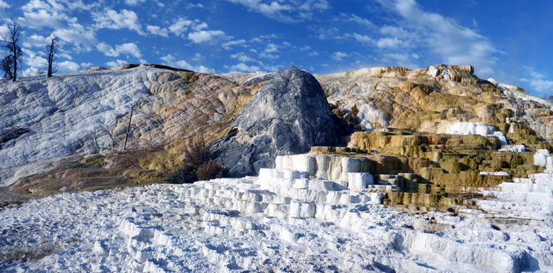
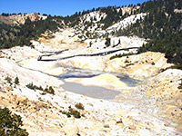
Liberty Cap and Palette Spring
There are several parking places along the main road near the Lower Terraces, and if full there is usually space along Opal Way, a dead-end side street on the east side of the highway. The northernmost thermal feature is Hymen Terrace along the south bank of Clematis Creek, viewed from the lower end of the trail to Beaver Ponds and Sepulcher Mountain; also in the vicinity is Liberty Cap, a 40 foot high travertine cone from a long extinct spring. South of here is the first trail into the terraces, formerly a loop, though recent thermal activity has blocked the upper end, turning it into a 400 foot long spur, passing beneath the currently most colorful terrace, formed by Palette Spring - an elongated array of little pools and trickling water, sprinkled with a few dead trees. Run-off from the spring has partially enveloped Devils Thumb, another grey geyserite cone, rather smaller than Liberty Cap. Close by, at slightly higher elevation, is New Palette Spring, viewed from the next trail south.
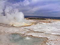
The Main Terraces at Mammoth
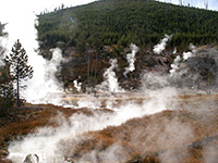
The next path southwards leaves the road beside the dormant Cavern Terrace and loops all around Minerva Terrace, a formerly large and colorful structure but now nearly all grey and dry. On the far side, slightly off-trail and close to the edge of the forest, is Cleopatra Terrace, a sizeable area of yellow and orange flow formations. Jupiter Terrace, on the south side of the loop, is also generally inactive, but adjacent Mound Terrace is a little more colorful. Another trail climbs a gentle slope and intersects the upper terrace drive, past a few minor pools (one, New Blue Spring may be dry, or filled with hot, bluish water) and on to Canary Spring at the south edge of the Main Terrace, which again, apart from the spring and a few other areas, is mostly dull-colored.
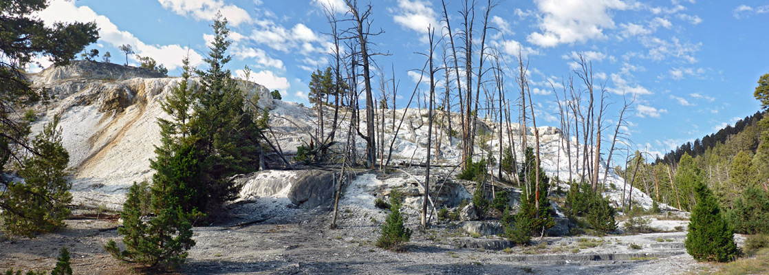
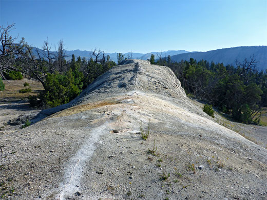
The Upper Mammoth Terraces
Walking counter-clockwise along the road from the lower terrace link path, the first significant formation is Narrow Gauge Terrace, a long, thin, whitish ridge which is most active towards its far end. This is closely followed by Cheops Mound and the dormant Prospect Terrace and then, on the south side of the road, the pretty New Highland Terrace, a mostly white formation about 300 feet long, with a few stark dead trees along the front. After a brief wooded patch, the road curves round Orange Spring Mound, a prominent travertine hill with an active orange area on the west side, and the similarly colored Tangerine Spring to the east; it then continues to the pure white Aphrodite Terrace. On the opposite side of the drive is Bath Lake, occasionally a sizeable warm pool but usually completely dry. Ladies Lake is nearby, though out-of-sight of the road, filled by cloudy greyish water and lined by orange algae. The southern reaches of the loop road pass through more densely wooded ground where the thermal features are smaller and generally not beside the road, one exception being White Elephant Back Terrace, another long, white, ridge-like formation with just a few small active areas. The road curves back to the north past the connection with US 89; opposite the junction is Angel Terrace, which has some large bright orange patches. From here a short walk further north reaches the edge of the lower terraces and the path back down to the starting point.

Mammoth Terraces - Similar Hikes
All Contents © Copyright The American Southwest | Comments and Questions | Contribute | Affiliate Marketing Disclosure | Site Map