Sepulcher Mountain Trail, Yellowstone National Park
Wyoming > Yellowstone National Park > The North > Hiking > Sepulcher Mountain Trail

Sepulcher Mountain
High, isolated summit on the west side of Mammoth, topped by dark, volcanic cliffs and pinnnacles. Reached by steep paths up the south and east slopes, forming a loop (incuding the Snow Pass Trail), through varied terrain of grassland, forest, meadows and riparian canyons
Length: 11.8 miles (round trip)
Elevation change: 3,360 feet
Difficulty: Strenuous
Type: Loop, connecting with other routes to Beaver Ponds, Fawn Pass and Sportsman Lake
Usage: Low
Season: Late spring, summer, fall
Trailhead: Mammoth
Rating (1-5): ★★★★★
Elevation change: 3,360 feet
Difficulty: Strenuous
Type: Loop, connecting with other routes to Beaver Ponds, Fawn Pass and Sportsman Lake
Usage: Low
Season: Late spring, summer, fall
Trailhead: Mammoth
Rating (1-5): ★★★★★

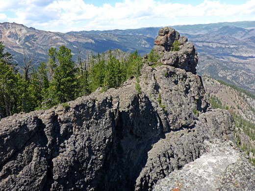
There are plenty of higher peaks in Yellowstone National Park, but 9,646 foot Sepulcher Mountain in the Gallatin Range is notable for its prominence, rising over 4,000 feet above the Gardner River along the north edge of the park, just west of Mammoth Hot Springs, and the strenuous route to the summit has the second highest elevation gain of any Yellowstone hiking path (3,360 feet) behind only the remote Cache Creek Trail, 100 feet more. The upper slopes fall away very steeply to the north, and are formed of jagged cliffs and pinnacles of dark volcanic rocks, the outline of which reminded early travelers of a tombstone, which is why the peak received its name, bestowed by the Barlow party of 1871.
The other sides are less steep, covered by woodland or short grass, allowing two trails to approach. The shortest route (4.9 miles) is from the east, starting beside the main terraces at Mammoth - this is the Sepulcher Mountain Trail, which climbs the steep, wooded valley of Clematis Creek then ascends further to a sloping ridgeline, which is followed to the summit. The same trail continues south, zig-zagging down mostly treeless hillsides to a junction with the Snow Pass Trail near Glen Creek, and this is used to complete the loop - beside the creek a way, across a meadow to the eponymous pass and finally down densely wooded slopes back to the Mammoth terraces.
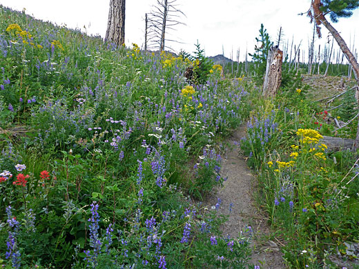
The elevation change is more gradual on the southern route hence clockwise is the preferred direction - up the Snow Pass Trail and down via the main section of the Sepulcher Mountain Trail, for a total of 11.8 miles, taking between five and eight hours. The hike traverses varied habitats, of moist meadows, dry grassland, coniferous forest, riparian canyons and volcanic cliffs, plus the thermal areas around Mammoth, all resulting in a great variety of wildflowers.
The trails are usually free of snow relatively early in the season owing to the south- and east-facing aspect of the mountain slopes, and the general lack of tree cover across the upper reaches. Wildlife in the area may include moose, especially in the meadows around Glen Creek, and grizzly bears, though these mostly stay a little way west; the nearest bear management area (Gallatin) extends just to the western edge of Sepulcher Mountain.
Trail map for Yellowstone National Park, topographic map of the Sepulcher Mountain area.
23 views along the Sepulcher Mountain Trail.
The usual place to park is at Mammoth, beside the lower terraces, though the hike can also start further south along the highway, either at the turn-off for the Upper Terrace Drive, or at the Snow Pass trailhead, at a small pull-out a little way beyond, on the east side of the road.
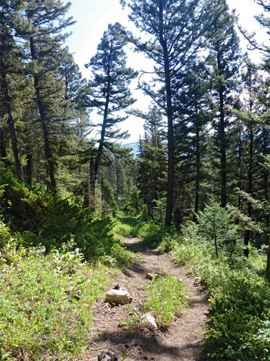
There are two options for the first part of the clockwise route to Sepulcher Mountain, from Mammoth - one is to walk a short distance along the Beaver Ponds Trail to a junction, and turn left at the first junction (Golden Gate/Howard Eaton Trail), a narrow path which skirts the lower terraces and proceeds south across wooded slopes close to the Upper Terrace Drive, while the other is to take the boardwalk path across the lower terraces, followed by a section of the Upper Terrace Drive, passing such features as Prospect Terrace, New Highland Terrace and Orange Spring Mound, before joining the other route via a short connecting path. After this junction, the trail stays heading south, across flat-floored woodland of tall, old growth trees to the junction with the Snow Pass Trail, the start point of which, along the road, is a quarter of a mile east.
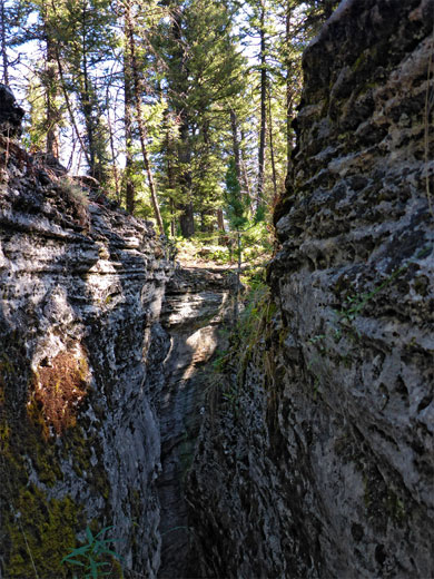
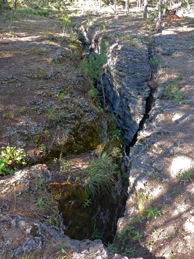
To the west is a steep hillside, bisected by a minor drainage, and the path climbs alongside, briefly curving away northwards then up some more to another wooded flat, an ancient, dormant thermal area named Pinyon Terrace. One feature of note, right beside the path on the south side, is a very narrow fissure, a few feet wide at the top and several hundred feet deep - a dropped stone bounces for about four seconds. The Snow Pass Trail climbs more gently on the far side of the terrace, to a sunny clearing encircled by tall undergrowth, and on to a junction, on the right, with the one mile Clagett Butte Trail; this ascends via three switchbacks to a grassy plateau overlooking Mammoth, drops down the far side, crosses Clematis Creek and rises a short distance to the junction with the Sepulcher Mountain Trail, and so can be used as a variant of the usual loop.
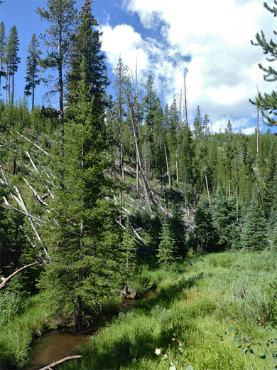
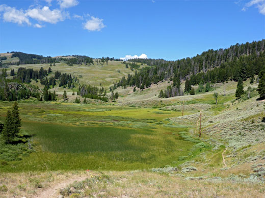
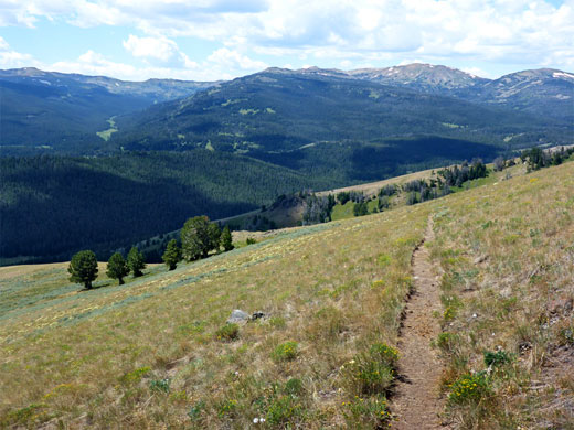
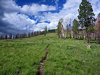
The Snow Pass Trail continues west, climbing a bit more steeply through moist, shady forest, passing a huge group of coneflowers, to the 7,475 foot pass, and along the open, grassy corridor on the far side, dotted with patches of trees and sagebrush. The land slopes down a little more to a bigger flat area, partly marshy, where the trail runs along the north edge, following some powerlines to a junction (3.3 miles from the start) at the edge of more extensive grassland to the southwest, known as Gardners Hole. Here the Fawn Pass Trail heads south while the Snow Pass Trail is north, entering a briefly narrow section of the overgrown valley of Glen Creek. The path is right beside the stream for a while before gradually rising across open slopes on the north side of the valley, over a tributary stream to the next junction; the Sportsman Lake Trail begins to the left while right is the south end of the Sepulcher Mountain Trail. This latter path switchbacks up more treeless slopes, into a shady glen and back out to the open, followed by a longer ascent up a little-changing hillside. Poles mark the end of the straight sections, to help identify the route when the land is snow-covered.
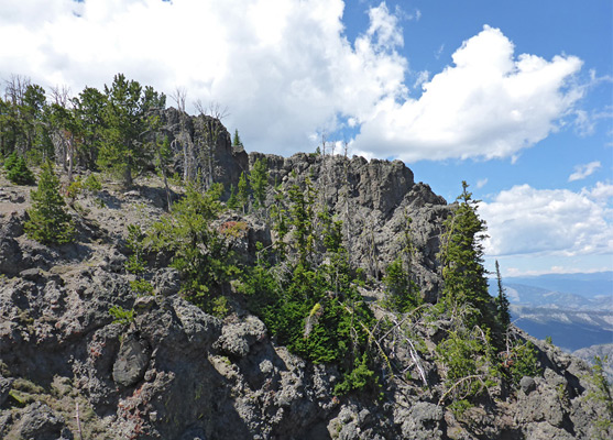
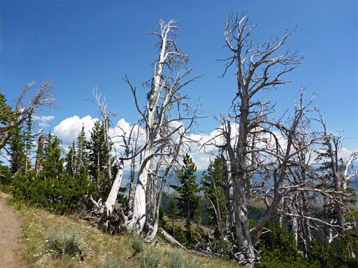
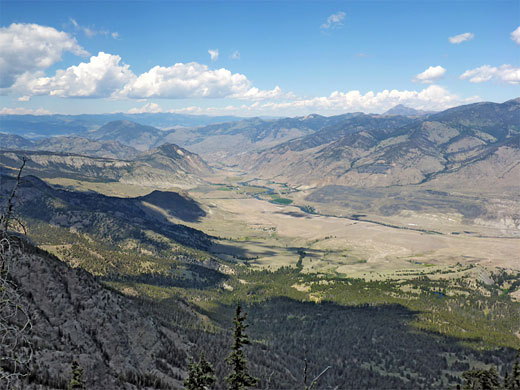
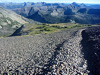
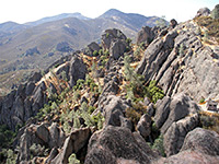
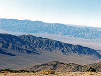
The trail approaches a patch of dead trees, while climbing along a minor ridgeline, near some rocky outcrops. The ridge is followed upwards, still quite steeply, to a false summit, then along flatter land with sparse trees, past another minor highpoint and finally to the main summit, on the north side of the peak. The best views are from a little spur off the main path, at a promontory of dark, irregular rocks, which has unobscured views of the Gardner River valley far below, north to the mountains of the Absaroka Range, and west to Electric Peak and other remote Yellowstone summits. Mammoth is hidden by lower hills to the east. Several species of Alpine wildflowers grow in crevices in the exposed rocks, including yellowdot saxifrage and cliff woodbeauty. To the north the land falls away precipitously into a mass of cliffs, fissures and narrow ravines.
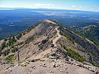
The eastwards descent from Sepulcher Mountain is initially very steep, along the top of a line of sheer cliffs, which allow good views back west towards the exposed, volcanic rocks at the top of the mountain. The path is slippery due to loose stones, and the land on the far side is wooded at first, until the trees give way to a sizeable grassy clearing, and the path moves away from the cliff edge, still descending steeply, then re-enters the woods on the far side, where the gradient eases. The ground is nearly level for a while, even rising at one point, until the path comes out of the forest and moves along a ridge, curving right and winding round the heads of several small valleys, traversing open slopes to the rim of a steep-sided basin. More steep switchbacks take the path down a grassy slope, home to many wildflowers, to the bushy, rocky terrain below, where again the walking is somewhat difficult because of loose rocks. The trail then enters new growth woodland of small, closely spaced trees where the views are limited, before crossing several small streams as the land becomes more sloping, and the surroundings less enclosed.
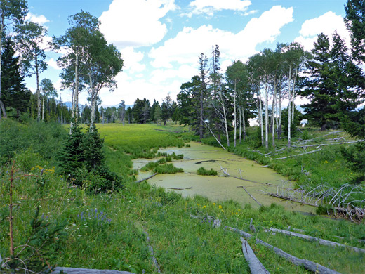
A pretty, algae-covered pond is passed on the left as the trail descends some more, past a few small seeps, down to the junction with the Clagett Butte Trail near Clematis Creek, which flows down a wide valley, partly wooded, and steep-sided around the streambed. The Sepulcher Mountain Trail runs down the east side of the valley, generally staying some distance above the creek, descending steadily through a mix of trees and long grass meadows to the Beaver Ponds junction. The final stretch has several long straights, over mostly open hillsides, before crossing the creek on a wooden bridge, past the link path to the Snow Pass Trail and finally emerging beside Hymen Terrace, at the north edge of the Mammoth thermal area.
The other sides are less steep, covered by woodland or short grass, allowing two trails to approach. The shortest route (4.9 miles) is from the east, starting beside the main terraces at Mammoth - this is the Sepulcher Mountain Trail, which climbs the steep, wooded valley of Clematis Creek then ascends further to a sloping ridgeline, which is followed to the summit. The same trail continues south, zig-zagging down mostly treeless hillsides to a junction with the Snow Pass Trail near Glen Creek, and this is used to complete the loop - beside the creek a way, across a meadow to the eponymous pass and finally down densely wooded slopes back to the Mammoth terraces.
The elevation change is more gradual on the southern route hence clockwise is the preferred direction - up the Snow Pass Trail and down via the main section of the Sepulcher Mountain Trail, for a total of 11.8 miles, taking between five and eight hours. The hike traverses varied habitats, of moist meadows, dry grassland, coniferous forest, riparian canyons and volcanic cliffs, plus the thermal areas around Mammoth, all resulting in a great variety of wildflowers.
The trails are usually free of snow relatively early in the season owing to the south- and east-facing aspect of the mountain slopes, and the general lack of tree cover across the upper reaches. Wildlife in the area may include moose, especially in the meadows around Glen Creek, and grizzly bears, though these mostly stay a little way west; the nearest bear management area (Gallatin) extends just to the western edge of Sepulcher Mountain.
Location
Trail map for Yellowstone National Park, topographic map of the Sepulcher Mountain area.
Photographs
23 views along the Sepulcher Mountain Trail.
Sepulcher Mountain Trailhead
The usual place to park is at Mammoth, beside the lower terraces, though the hike can also start further south along the highway, either at the turn-off for the Upper Terrace Drive, or at the Snow Pass trailhead, at a small pull-out a little way beyond, on the east side of the road.
Mammoth Terraces
There are two options for the first part of the clockwise route to Sepulcher Mountain, from Mammoth - one is to walk a short distance along the Beaver Ponds Trail to a junction, and turn left at the first junction (Golden Gate/Howard Eaton Trail), a narrow path which skirts the lower terraces and proceeds south across wooded slopes close to the Upper Terrace Drive, while the other is to take the boardwalk path across the lower terraces, followed by a section of the Upper Terrace Drive, passing such features as Prospect Terrace, New Highland Terrace and Orange Spring Mound, before joining the other route via a short connecting path. After this junction, the trail stays heading south, across flat-floored woodland of tall, old growth trees to the junction with the Snow Pass Trail, the start point of which, along the road, is a quarter of a mile east.
Pinyon Terrace
To the west is a steep hillside, bisected by a minor drainage, and the path climbs alongside, briefly curving away northwards then up some more to another wooded flat, an ancient, dormant thermal area named Pinyon Terrace. One feature of note, right beside the path on the south side, is a very narrow fissure, a few feet wide at the top and several hundred feet deep - a dropped stone bounces for about four seconds. The Snow Pass Trail climbs more gently on the far side of the terrace, to a sunny clearing encircled by tall undergrowth, and on to a junction, on the right, with the one mile Clagett Butte Trail; this ascends via three switchbacks to a grassy plateau overlooking Mammoth, drops down the far side, crosses Clematis Creek and rises a short distance to the junction with the Sepulcher Mountain Trail, and so can be used as a variant of the usual loop.

Snow Pass and Glen Creek
The Snow Pass Trail continues west, climbing a bit more steeply through moist, shady forest, passing a huge group of coneflowers, to the 7,475 foot pass, and along the open, grassy corridor on the far side, dotted with patches of trees and sagebrush. The land slopes down a little more to a bigger flat area, partly marshy, where the trail runs along the north edge, following some powerlines to a junction (3.3 miles from the start) at the edge of more extensive grassland to the southwest, known as Gardners Hole. Here the Fawn Pass Trail heads south while the Snow Pass Trail is north, entering a briefly narrow section of the overgrown valley of Glen Creek. The path is right beside the stream for a while before gradually rising across open slopes on the north side of the valley, over a tributary stream to the next junction; the Sportsman Lake Trail begins to the left while right is the south end of the Sepulcher Mountain Trail. This latter path switchbacks up more treeless slopes, into a shady glen and back out to the open, followed by a longer ascent up a little-changing hillside. Poles mark the end of the straight sections, to help identify the route when the land is snow-covered.
Sepulcher Mountain Summit
The trail approaches a patch of dead trees, while climbing along a minor ridgeline, near some rocky outcrops. The ridge is followed upwards, still quite steeply, to a false summit, then along flatter land with sparse trees, past another minor highpoint and finally to the main summit, on the north side of the peak. The best views are from a little spur off the main path, at a promontory of dark, irregular rocks, which has unobscured views of the Gardner River valley far below, north to the mountains of the Absaroka Range, and west to Electric Peak and other remote Yellowstone summits. Mammoth is hidden by lower hills to the east. Several species of Alpine wildflowers grow in crevices in the exposed rocks, including yellowdot saxifrage and cliff woodbeauty. To the north the land falls away precipitously into a mass of cliffs, fissures and narrow ravines.

The Descent to the East
The eastwards descent from Sepulcher Mountain is initially very steep, along the top of a line of sheer cliffs, which allow good views back west towards the exposed, volcanic rocks at the top of the mountain. The path is slippery due to loose stones, and the land on the far side is wooded at first, until the trees give way to a sizeable grassy clearing, and the path moves away from the cliff edge, still descending steeply, then re-enters the woods on the far side, where the gradient eases. The ground is nearly level for a while, even rising at one point, until the path comes out of the forest and moves along a ridge, curving right and winding round the heads of several small valleys, traversing open slopes to the rim of a steep-sided basin. More steep switchbacks take the path down a grassy slope, home to many wildflowers, to the bushy, rocky terrain below, where again the walking is somewhat difficult because of loose rocks. The trail then enters new growth woodland of small, closely spaced trees where the views are limited, before crossing several small streams as the land becomes more sloping, and the surroundings less enclosed.
Clematis Creek
A pretty, algae-covered pond is passed on the left as the trail descends some more, past a few small seeps, down to the junction with the Clagett Butte Trail near Clematis Creek, which flows down a wide valley, partly wooded, and steep-sided around the streambed. The Sepulcher Mountain Trail runs down the east side of the valley, generally staying some distance above the creek, descending steadily through a mix of trees and long grass meadows to the Beaver Ponds junction. The final stretch has several long straights, over mostly open hillsides, before crossing the creek on a wooden bridge, past the link path to the Snow Pass Trail and finally emerging beside Hymen Terrace, at the north edge of the Mammoth thermal area.
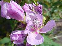
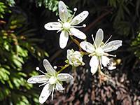
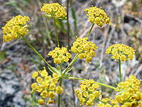
Sepulcher Mountain Wildflowers
More flowers along the trail
 Streambank globemallow |
 Yellowdot saxifrage |
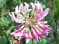 Alsike clover |
 American thorow wax |
More flowers along the trail
Sepulcher Mountain Trail - Similar Hikes
All Contents © Copyright The American Southwest | Comments and Questions | Contribute | Affiliate Marketing Disclosure | Site Map