The North, Yellowstone National Park: Mammoth, Tower and the Lamar Valley
Wyoming > Yellowstone National Park > The North
Highlights:
The north section of Yellowstone National Park - Gardiner, Mammoth Hot Springs, Tower, Roosevelt, Yellowstone River and the Lamar Valley, plus many trails

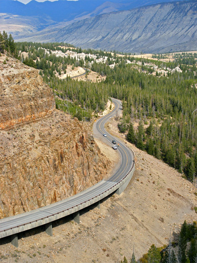
The northern approach to Yellowstone National Park is via US 89 in southwest Montana, which follows the Yellowstone River valley through the Gallatin National Forest, and enters the park at the small town of Gardiner. The valley is wooded and quite steep sided, and just north of town are several places for free camping, along short side tracks off the highway.
The Gardiner entrance is the only one of the five that remains open all year, since it has the lowest elevation, and the town provides all necessary facilities including a selection of accommodation, though sometimes this is quite expensive and needs early advance booking. One notable historical feature is Roosevelt Arch, dedicated in 1903 by the 26th president, marking what was at the time the main entrance to the national park.
The Gardiner entrance is the only one of the five that remains open all year, since it has the lowest elevation, and the town provides all necessary facilities including a selection of accommodation, though sometimes this is quite expensive and needs early advance booking. One notable historical feature is Roosevelt Arch, dedicated in 1903 by the 26th president, marking what was at the time the main entrance to the national park.
North Yellowstone Table of Contents
Photographs
The north, Beaver Ponds, Blacktail Deer Creek, Mammoth Terraces, Yellowstone River Picnic Area Trail.
Video
Blacktail Deer Creek.
Yellowstone Tours
Explore the Lamar Valley, home of much wildlife.
Mammoth
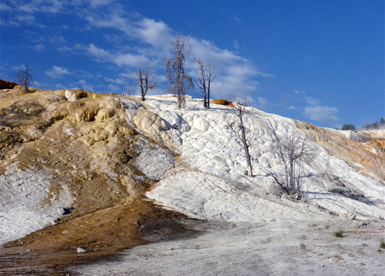
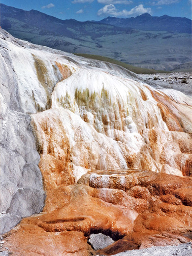
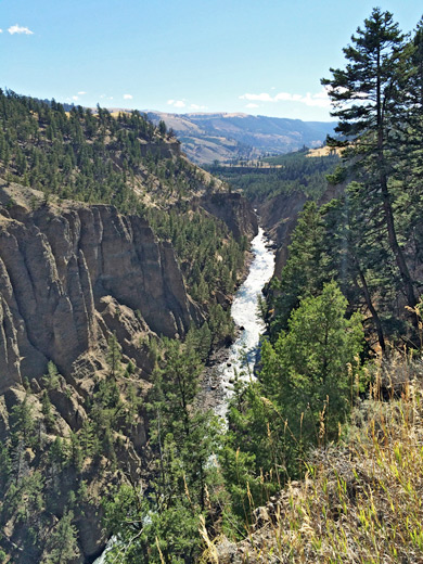
East of Gardiner, the Yellowstone River enters a rather deeper canyon - Black Canyon of the Yellowstone - though this is not accessible by road and instead requires a hike of either 2 miles (Garnet Hill Trail) or 3.5 miles (Blacktail Deer Creek Trail). Instead, the entrance road heads due south, following the Gardner River for 5 miles to Mammoth, site of the only major thermal area in the north of Yellowstone National Park. The formations here are different to most others, with no geysers or large pools, instead the warm, subterranean water has created large areas of beautiful terraces; staircase-like structures made of deposited travertine, stained a variety of bright colors by bacteria and algae that live in the acidic waters. Mammoth is also the location of a small village that includes a hotel, the historic Fort Yellowstone (built in 1891), a visitor center and an assortment of shops. In late summer and early fall the lawns and fields nearby are some of the best places in the park to view elk. The road forks in the middle of the village - east leads to the Tower and Canyon areas while south passes the terraces and formations then continues through a long, wooded valley towards Norris Geyser Basin. There are varied hiking opportunities in the Mammoth area including Beaver Ponds, Bunsen Peak, Osprey Falls and Sepulcher Mountain - see the hiking index for full details.
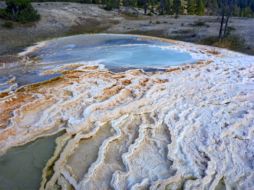
Mammoth Terraces
The main highway affords a fine view of the Mammoth terraces as it winds up a steep hillside, but trails, boardwalks and a one-way loop drive give much better access. The formations occur in two main areas - the Lower and Upper Terraces. The lower region has the largest deposits, over an area half a mile across, principally Palette Spring, Canary Spring, the Jupiter, Minerva and Cleopatra Terraces plus numerous lesser pools and springs. The Upper Terrace is a less geologically active region and its features are more dispersed, the surroundings more wooded. A narrow road, not for vehicles over 25 feet, passes structures such as Prospect Terrace, Angel Terrace and Orange Spring Mound, and has good elevated views over all the Mammoth formations. The majority of the terraces have become noticeably less productive and less colorful in recent years, however; the pools have dried up, the algae has died and hence the bright hues have faded, and now most of the area is a dull white or gray color, though still with a few small hot springs dotted about, each surrounded by a ring of yellow cyanobacteria. All thermal features, in both the upper and lower terraces, can be seen by a loop hike of 2.8 miles.
Tower
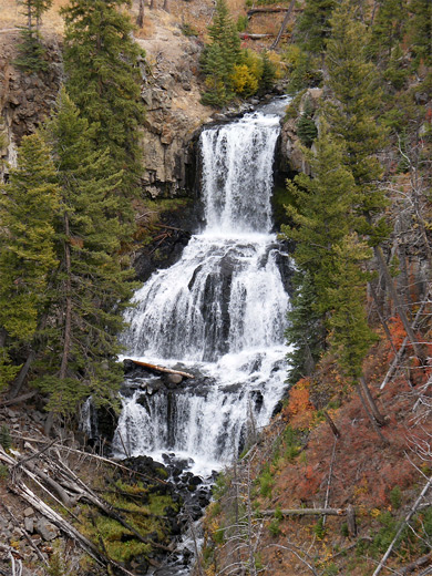
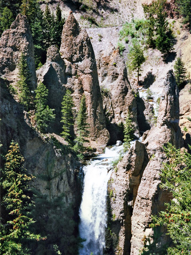
East of Mammoth, the Grand Loop Road re-crosses the Gardner River, climbs quite steeply up the side valley of Lava Creek (past two easily-reached waterfalls: Undine, right by the road and Wraith, at the end of a short trail) then enters a mostly treeless plateau en route to Tower Junction, site of a ranger station, picnic area and the venerable Roosevelt Lodge, which has cabins, a store, restaurant, gas station and horse rentals. The main attraction hereabouts is the 132 foot Tower Falls, where a tributary of the Yellowstone River (Tower Creek) flows through a group of unusual, sharply pointed volcanic spires then cascades down into a narrow, wooded canyon. The falls have a short trail leading to an overlook and a longer path down to the base, though this is currently closed because of safety concerns. Like all Yellowstone waterfalls, the amount of flow is greatest during the snowmelt season in early summer. A variety of other trails start nearby, including one to the secluded waters of Lost Lake, and one alongside the Yellowstone River. South of Tower, the loop road heads south, climbing into the foothills of 10,243 foot Mount Washburn then descending through forested land to the Canyon region, while the road eastwards soon reaches the Lamar Valley.
Beyond Tower - the Lamar Valley
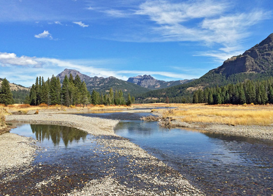
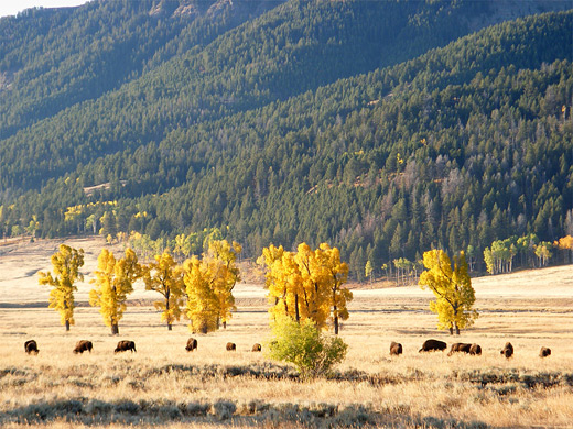
There are no geothermal features anywhere in northeast Yellowstone National Park since this area lies well outside the region occupied by the former volcano; instead, the road east of Tower crosses more forests and meadows, running alongside the Lamar River for a while then turning northeast, exiting the park at the Wyoming/Montana border. Like Hayden Valley to the south, Lamar Valley is a wide open, grassy expanse which offers a good chance of spotting wildlife, and is the most likely place to see wolves and grizzly bears, as well as being the least visited and least developed section of the national park. Even here though, at some times of year, there may be many dozens of vehicles parked in the pull-outs along the highway, which runs parallel to the river but a little way above it, so offering a good perspective down onto the grassland, and making it quite easy to spot animals even a mile or so away. Bison are most common here, and many hundreds may often be seen, sometimes walking right next to or along the road. The Yellowstone Institution runs a bison study center in the valley, located half way between Tower and the northeast entrance, and there are usually several animals roaming the compound.
Northeast Yellowstone Entrance
The road leaves the Lamar River after 13 miles, heading northeast along a lesser ravine formed by Soda Butte Creek, as the surroundings become wooded and mountainous. Past the national park boundary, two small towns (Silver Gate and Cooke City) offer basic facilities, before the highway (US 212) begins a long, continuous descent through mostly empty land of the Shoshone National Forest. Unusually for a USFS preserve, free camping is not allowed on side tracks leading off the road, though this is possible once about 15 miles from the park.
Hiking in North Yellowstone
All trails in the north of Yellowstone
Featured Trails
Beaver Ponds
★★★★★
★★★★★
5.0 miles, 450 feet (loop)
The pleasant trail to a group of beaver-inhabited ponds north of Mammoth village has two trailheads 1/4 mile apart
Blacktail Deer Creek
★★★★★
★★★★★
3.5 miles, 1100 feet
Most of the this trail crosses relatively open ground with grassy meadows and patches of woodland though the last part is steep, down a narrow ravine as it approaches the Yellowstone River, which is crossed on a footbridge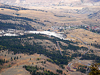
Bunsen Peak
★★★★★
★★★★★
4 miles, 1380 feet
Bunsen Peak, a circular, solitary, volcanic summit, affords excellent views of the Mammoth area and the surrounding mountains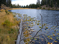
Lost Lake
★★★★★
★★★★★
4 miles, 600 feet
Starting right next to Roosevelt Lodge at Tower Junction, this loop trail climbs a wooded hillside and enters a hidden valley containing lily pad-covered Lost Lake, then follows Yancey Creek at the far side of the lake to a petrified redwood tree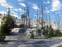
Mammoth Terraces
★★★★★
★★★★★
2.8 miles, 520 feet (loop)
The terraces, pools and dormant thermal features of Mammoth Hot Springs, viewed by walking along interconnected loop trails and a one-way road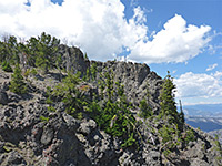
Sepulcher Mountain
★★★★★
★★★★★
11 miles, 3360 feet (loop)
Strenuous climb through forest, meadows and grassland to a high peak on the west side of Mammoth, topped by a group of volcanic pinnacles; a loop hike, including the Snow Pass Trail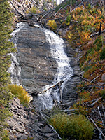
Wraith Falls
★★★★★
★★★★★
0.3 miles, 120 feet
The very short route to 100 foot Wraith Falls starts a quarter mile east of the Lava Creek Picnic area, 5 miles from Mammoth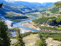
Yellowstone River Picnic Area
★★★★★
★★★★★
2 miles, 400 feet
This easy trail follows the east side of the cliffs at the downstream end of the Grand Canyon of the Yellowstone River, to a place known as The NarrowsAll Contents © Copyright The American Southwest | Comments and Questions | Contribute | Affiliate Marketing Disclosure | Site Map