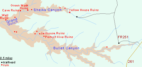
Bullet Canyon
Large Grand Gulch tributary sheltering two significant Anasazi sites, Perfect Kiva Ruins and Jailhouse Ruins, together with several granaries. The lower end contains a flowing stream and has many good places for camping
Length: 4.5 miles to Jailhouse Ruins, 4.4 miles to the lower end of Bullet Canyon, 6.7 miles to Grand Gulch. 14 miles for the Sheiks/Bullet loop
Elevation change: 900 feet
Difficulty: Moderate - a few steep and rocky places
Type: One way, or loop with adjacent Sheiks Canyon
Usage: Low to medium
Season: Spring, fall - winters are cold and potentially snowy, while summers are very hot
Trailhead: 1.1 miles from UT 261 along a good dirt track
Rating (1-5): ★★★★★

Bullet Canyon is the largest tributary of upper Grand Gulch, its enclosed section running east-west for about 6 miles, and becoming 800 feet deep around the confluence. The lowest couple of miles have a wide, grassy floor around a permanent stream with many good potential camping places, but the main attractions are two extensive, well preserved Anasazi sites, Perfect Kiva Ruins and Jailhouse Ruins, situated close together about 4.5 miles down the canyon.
Downstream are several smaller ruins, before Bullet Canyon joins Grand Gulch, 1 mile below the junction with another tributary (Sheiks Canyon) which can be combined with Bullet to make a 14 mile loop. For day trips Bullet is more popular since the trailhead is easily accessed, just 1 mile from UT 261. Jailhouse Ruins is named because of an unusual lattice window, and includes several intricate rooms, on two levels, surrounded by strangely eroded sandstone. Perfect Kiva Ruins feature a complete (partly restored) kiva, plus several impressive rooms and other smaller structures. Both sites also have petroglyphs and pictographs.
Guidelines for visiting archaeological sites
The Bullet Canyon trailhead is 1 mile along FR 251, an unpaved road which leaves the west side of UT 261 between mileposts 21 and 22; the location has plenty of parking space, a trailhead register, map, and pay station for the $2 Cedar Mesa day hiking fee. The road continues northwards, eventually looping back to the highway, while a rougher track forks west after another mile, leading to the less visited trailhead for Sheiks Canyon.
The trailhead lies close to the north rim of Bullet Canyon, already somewhat enclosed; the path stays on the mesa top a way before a short descent to the overgrown streambed, which contains flowing water in a few places. The gorge deepens only gradually, and the path stays beside the creek, through a mix of slickrock, grassy areas and patches of woodland. After about half a mile, a small rim-level ruin comes into view, on the north side - the lower portion of a square tower, built right at the edge of a protruding rock. A climb-up route enables closer views. The path continues by the stream, under a large overhang, past a shallow south-side tributary and a larger one to the north, where it curves round beneath a dryfall and descends a sloping slickrock chute, as the drainage becomes noticeably deeper. Round the next bend, the trail moves to a bench on the north side, staying quite level for a quarter of a mile, then drops down a bouldery slope back to the stream bed, which has several pools at intervals, some nice and clear, others deep and muddy.
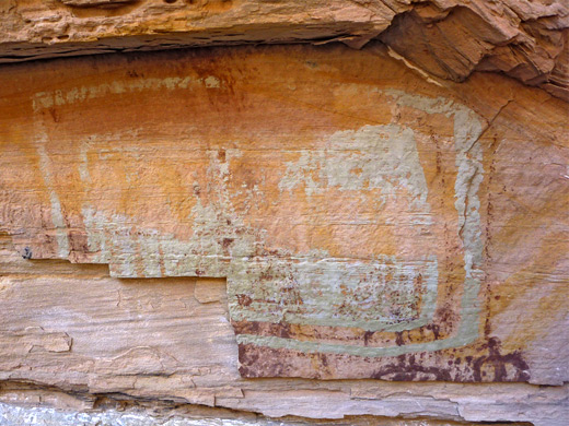
The creek flows intermittently, through horsetail and other dense undergrowth, round several bends and into a long straight, with another tributary to the south and several on the north, separated by narrow ridges. The east side of one of these ridges conceals Perfect Kiva Ruins, well hidden in an alcove and set back from the main channel, but its location is evident from a cairned path which branches off into the side ravine. This climbs a soil slope and then slickrock to the alcove, which has a sizeable, flat floor that allowed for extensive construction, including the kiva itself (entered via a replacement ladder), a well presented, square-walled dwelling house, several other rooms and a small structure lined by boulders marked with metate grooves. There are various petroglyphs, pictographs and 19th-century signatures on the cliff face above the ruins, all rather faded.
Close by, at the edge of the next fin, is Jailhouse Ruin, named because of a small window guarded by a lattice of criss-crossing sticks. Other parts have equally intricate construction such as thin, stick-reinforced walls, neat doorways, and a table built on a sloping surface - all set against a layered cliff face of strangely-eroded, holey sandstone. The ruin spans two levels but the upper part is inaccessible, though three large, white, circular pictographs in this section can be clearly seen from below. The ground is littered with many pot fragments and corncobs.
Below Jailhouse Ruins, Bullet Canyon becomes more enclosed and overgrown for a short distance, containing another section of flowing stream, which winds through a tight S bend, past a protruding ridge with spires at the end, and into a long, straight, wide and grassy section. A granary is visible on the north side, close to the stream bed, formed of neat red brick walls. A big dryfall with deep pool below (passed to the north) is followed by another open, shadeless stretch, passing several other scattered Anasazi sites, all quite small, including a two door granary quite high up, just before the junction with Grand Gulch, where the vegetation increases again. Sheiks Canyon joins from the east one mile upstream. In general the path through Bullet Canyon is cairned and easy to follow, but the hike can be somewhat strenuous, especially in the summer since much is exposed and hot, shielded from any breeze by the high cliffs, though drinkable water is available from the intermittent stream.
Downstream are several smaller ruins, before Bullet Canyon joins Grand Gulch, 1 mile below the junction with another tributary (Sheiks Canyon) which can be combined with Bullet to make a 14 mile loop. For day trips Bullet is more popular since the trailhead is easily accessed, just 1 mile from UT 261. Jailhouse Ruins is named because of an unusual lattice window, and includes several intricate rooms, on two levels, surrounded by strangely eroded sandstone. Perfect Kiva Ruins feature a complete (partly restored) kiva, plus several impressive rooms and other smaller structures. Both sites also have petroglyphs and pictographs.
Guidelines for visiting archaeological sites

Map of Bullet and Sheiks Canyons
Bullet Canyon Trailhead
The Bullet Canyon trailhead is 1 mile along FR 251, an unpaved road which leaves the west side of UT 261 between mileposts 21 and 22; the location has plenty of parking space, a trailhead register, map, and pay station for the $2 Cedar Mesa day hiking fee. The road continues northwards, eventually looping back to the highway, while a rougher track forks west after another mile, leading to the less visited trailhead for Sheiks Canyon.
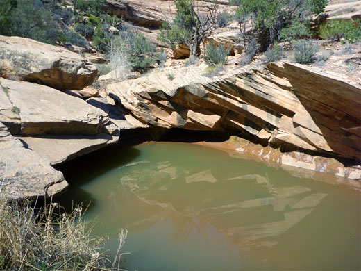
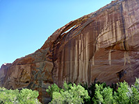
Upper Bullet Canyon
The trailhead lies close to the north rim of Bullet Canyon, already somewhat enclosed; the path stays on the mesa top a way before a short descent to the overgrown streambed, which contains flowing water in a few places. The gorge deepens only gradually, and the path stays beside the creek, through a mix of slickrock, grassy areas and patches of woodland. After about half a mile, a small rim-level ruin comes into view, on the north side - the lower portion of a square tower, built right at the edge of a protruding rock. A climb-up route enables closer views. The path continues by the stream, under a large overhang, past a shallow south-side tributary and a larger one to the north, where it curves round beneath a dryfall and descends a sloping slickrock chute, as the drainage becomes noticeably deeper. Round the next bend, the trail moves to a bench on the north side, staying quite level for a quarter of a mile, then drops down a bouldery slope back to the stream bed, which has several pools at intervals, some nice and clear, others deep and muddy.
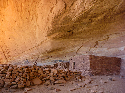
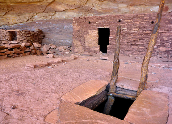
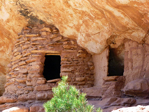
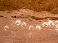
Perfect Kiva Ruins
The creek flows intermittently, through horsetail and other dense undergrowth, round several bends and into a long straight, with another tributary to the south and several on the north, separated by narrow ridges. The east side of one of these ridges conceals Perfect Kiva Ruins, well hidden in an alcove and set back from the main channel, but its location is evident from a cairned path which branches off into the side ravine. This climbs a soil slope and then slickrock to the alcove, which has a sizeable, flat floor that allowed for extensive construction, including the kiva itself (entered via a replacement ladder), a well presented, square-walled dwelling house, several other rooms and a small structure lined by boulders marked with metate grooves. There are various petroglyphs, pictographs and 19th-century signatures on the cliff face above the ruins, all rather faded.
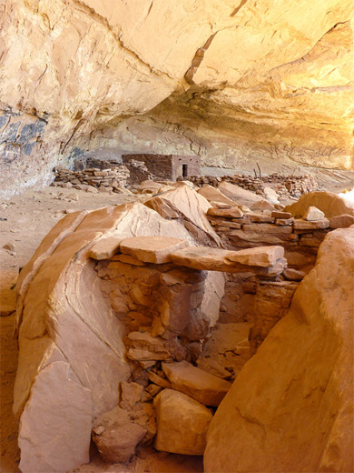
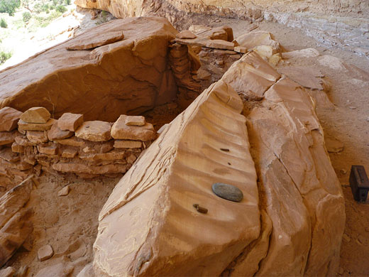
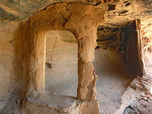
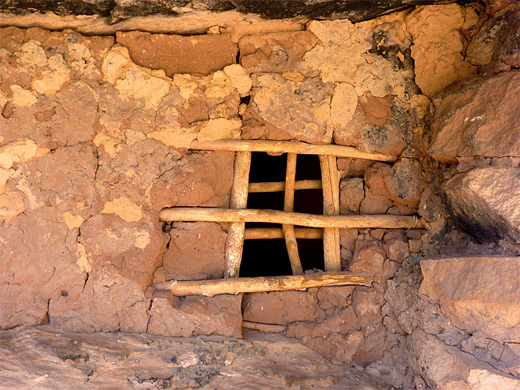
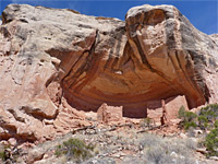
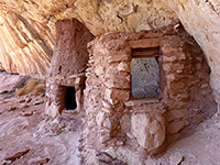
Jailhouse Ruins
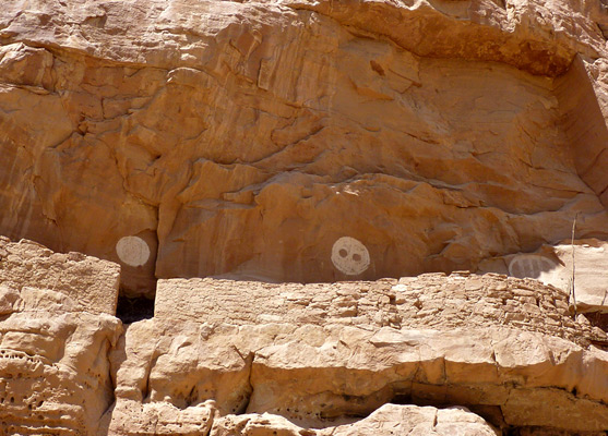
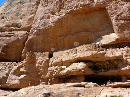
Close by, at the edge of the next fin, is Jailhouse Ruin, named because of a small window guarded by a lattice of criss-crossing sticks. Other parts have equally intricate construction such as thin, stick-reinforced walls, neat doorways, and a table built on a sloping surface - all set against a layered cliff face of strangely-eroded, holey sandstone. The ruin spans two levels but the upper part is inaccessible, though three large, white, circular pictographs in this section can be clearly seen from below. The ground is littered with many pot fragments and corncobs.
Lower Bullet Canyon
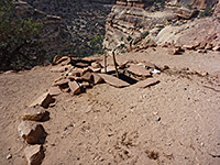
Below Jailhouse Ruins, Bullet Canyon becomes more enclosed and overgrown for a short distance, containing another section of flowing stream, which winds through a tight S bend, past a protruding ridge with spires at the end, and into a long, straight, wide and grassy section. A granary is visible on the north side, close to the stream bed, formed of neat red brick walls. A big dryfall with deep pool below (passed to the north) is followed by another open, shadeless stretch, passing several other scattered Anasazi sites, all quite small, including a two door granary quite high up, just before the junction with Grand Gulch, where the vegetation increases again. Sheiks Canyon joins from the east one mile upstream. In general the path through Bullet Canyon is cairned and easy to follow, but the hike can be somewhat strenuous, especially in the summer since much is exposed and hot, shielded from any breeze by the high cliffs, though drinkable water is available from the intermittent stream.
Bullet Canyon - Similar Hikes
All Contents © Copyright The American Southwest | Comments and Questions | Contribute | Affiliate Marketing Disclosure | Site Map