Lower Fish Creek
East-side Cedar Mesa canyon with a permanent stream draining into Comb Wash, containing about ten ancient sites including granaries, ruined settlements, pictographs and petroglyphs. Quite overgrown and not often visited
Length: 5 miles, to the tenth site
Elevation change: 250 feet
Difficulty: Easy to moderate - thick undergrowth in a few places, some stream crossings
Type: One way
Usage: Low
Season: Spring, summer, fall
Trailhead: End of a short track branching off the unpaved Comb Wash Road
Rating (1-5): ★★★★★
Elevation change: 250 feet
Difficulty: Easy to moderate - thick undergrowth in a few places, some stream crossings
Type: One way
Usage: Low
Season: Spring, summer, fall
Trailhead: End of a short track branching off the unpaved Comb Wash Road
Rating (1-5): ★★★★★

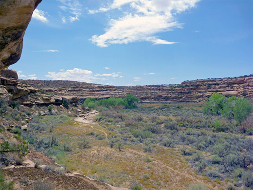
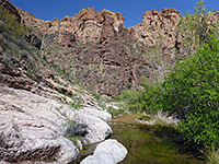
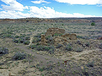
Fish Creek is a typically long but relatively shallow drainage on the east side of Cedar Mesa, flowing through a rather overgrown canyon which opens out at the lower end to a much wider valley below the steep west face of Comb Ridge, where the stream meets Comb Wash which leads south to the San Juan River.
There are many Anasazi ruins and rock art sites all along Fish Creek, and while the upper reaches are best explored from the west, via Hwy 261, the lower section is accessed via the unpaved but good quality Comb Wash Road, running between Hwy 95 and US 163. About ten main locations are spread out along 4 miles of the canyon, none especially dramatic but the group as a whole is varied, including mesa top ruins, alcove ruins, granaries, pictographs and petroglyphs.
A rough trail runs all through the valley, crossing the creek a few times, though the place is one of the less visited of the Cedar Mesa canyons, perhaps because of the relatively long distance from a paved road (9 miles). Some ruins take a little scrambling to reach, and a few sections of the canyon floor have thick undergrowth - an increasing problem in recent years, so the time needed is rather longer than might be expected, from 5 to 8 hours. The stream flows all year, mostly across earthen terrain between low, alluvial banks, but there are a few open, slickrock sections.
Guidelines for visiting archaeological sites
Map of Cedar Mesa, Grand Gulch and Comb Ridge.
26 views of lower Fish Creek.
Like Butler Wash Road on the east side of Comb Ridge, Comb Wash Road to the west is generally good for all vehicles, all year, being regularly maintained. There are a few bumpy wash crossings and short stretches of soft sand, however. Fish Creek is reached by a very short side track, branching off 9.4 miles south of Hwy 95 and 8.9 miles north of US 163; this ends at a small parking/camping area right next to the corridor of bushes and trees enclosing Comb Wash, though surrounded by flat, sandy land at either side. A BLM trailhead sign and register are located at the end of the track.
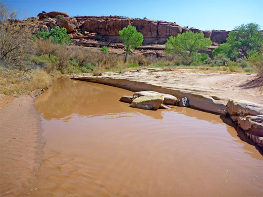
By the trailhead, Comb Wash is usually between one and two feet deep, and contains muddy water. The path starts by crossing the creek and the thin belt of bushes on the far side, where the route may not be evident, but it soon rises above the undergrowth to an open, sandy ridge, running alongside a fence where it is marked by a few more BLM signs. Fish Creek flows a short distance north; there is no canyon yet but ahead the land gradually rises and the trail drops down towards the wash as low cliffs form at either side, after half a mile. From here the canyon stays shallow, deepening only slowly so that the cliffs are just 300 feet high after 4.5 miles, at the furthest ruin site. The path stays on the south side of the creek initially, through surroundings that are quite overgrown, especially along the streamway, which is mostly hidden from view by dense thickets of willow and tamarisk. There are lots of spiky tumbleweed plants as well.
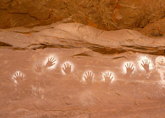
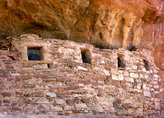
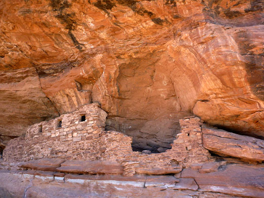
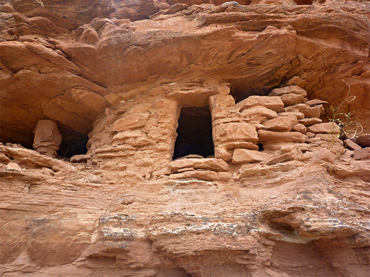
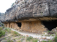
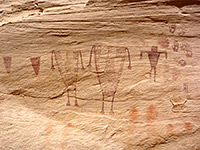
The path passes a dry, south-side tributary after 1.2 miles and comes within sight of the first ruins soon after, below the cliffs at the north edge of the canyon; a little route-finding may be necessary, to cross the creek. This first site has a small but photogenic ruin in an alcove, with four neat square windows in the front wall and a group of white handprint pictographs on the streaked orange sandstone wall above. Site two is not far beyond, past a little promontory, and contains two structures in a wider alcove, one beneath a row of especially crisp, white handprints, plus a larger, fainter group and some faded petroglyphs close by. These two sites are at the foot of the low cliffs to the north of a wide bend in the canyon, as the streamway curves to the southwest. Faint trails follow both sides of the creek but the main route still seems to be to the south; this passes a BLM fence and notice, then crosses to the north side for the first time, running for some distance along a vegetation-free rock bench.
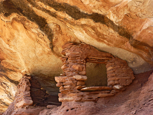
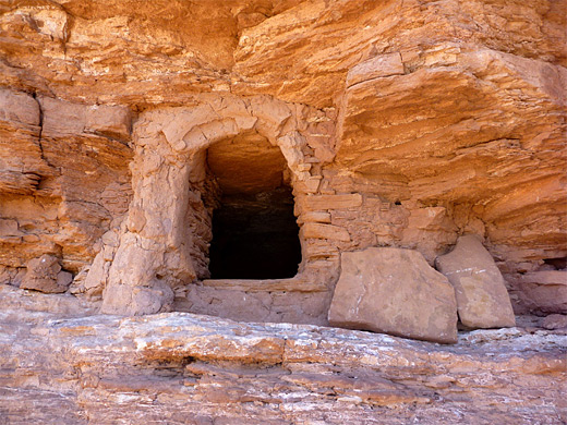
Site three is a partially complete granary with a neat window, built in an elevated alcove with good views up and down the valley. Site four is also a granary, quite high above a sand hill, this soon after the path moves back to the south side of the creek. Yet another granary is found at site five, a south-facing structure at the base of a big cliff.
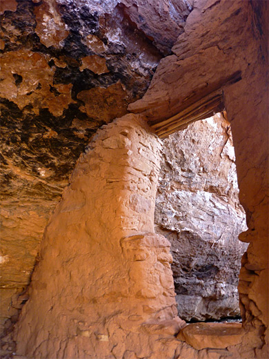
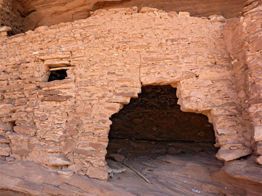
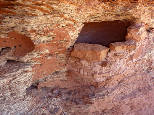
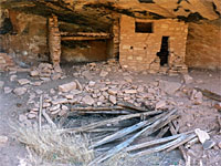
Two more crossings follow in quick succession as the stream flows through a tight U-bend. Site six is due south of this bend - another granary, on a ledge not far above the valley floor. The trail fords the creek for the last time and passes close to site seven, comprising a well preserved granary with two flat stones nearby, perhaps used as a door. A line of white triangular pictographs is visible just beyond, on the opposite side of a little ravine. The walk to the next location is a little longer, but easier, over flat land with a few bushes and no wash crossings. Site eight consists of a few wall remnants on a prominent boulder, 200 feet up on the south rim, reachable by a ten minute diversion.
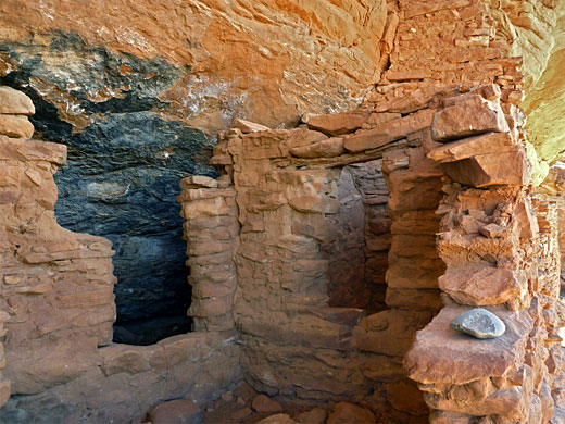
Site nine is a little way up the north side of the canyon; a series of walls, granaries and interlinked alcoves above a mound scattered with many pot fragments, and all surrounded by unusual, flaky, thin-layered and cross bedded sandstone. Site ten is the remains of a single room dwelling, built on a low, reddish hill just south of the stream in the middle of the canyon, which is nearly a mile across at its widest and still relatively shallow, but the walls steepen significantly not far upstream, where the two big tributaries join (McCloyd Canyon and Owl Creek). All three branches hold many more ruins, which are usually visited starting from Cedar Mesa to the west.
There are many Anasazi ruins and rock art sites all along Fish Creek, and while the upper reaches are best explored from the west, via Hwy 261, the lower section is accessed via the unpaved but good quality Comb Wash Road, running between Hwy 95 and US 163. About ten main locations are spread out along 4 miles of the canyon, none especially dramatic but the group as a whole is varied, including mesa top ruins, alcove ruins, granaries, pictographs and petroglyphs.
A rough trail runs all through the valley, crossing the creek a few times, though the place is one of the less visited of the Cedar Mesa canyons, perhaps because of the relatively long distance from a paved road (9 miles). Some ruins take a little scrambling to reach, and a few sections of the canyon floor have thick undergrowth - an increasing problem in recent years, so the time needed is rather longer than might be expected, from 5 to 8 hours. The stream flows all year, mostly across earthen terrain between low, alluvial banks, but there are a few open, slickrock sections.
Guidelines for visiting archaeological sites
Location
Map of Cedar Mesa, Grand Gulch and Comb Ridge.
Photographs
26 views of lower Fish Creek.
Fish Creek Access
Like Butler Wash Road on the east side of Comb Ridge, Comb Wash Road to the west is generally good for all vehicles, all year, being regularly maintained. There are a few bumpy wash crossings and short stretches of soft sand, however. Fish Creek is reached by a very short side track, branching off 9.4 miles south of Hwy 95 and 8.9 miles north of US 163; this ends at a small parking/camping area right next to the corridor of bushes and trees enclosing Comb Wash, though surrounded by flat, sandy land at either side. A BLM trailhead sign and register are located at the end of the track.
Lower End of Fish Creek Canyon
By the trailhead, Comb Wash is usually between one and two feet deep, and contains muddy water. The path starts by crossing the creek and the thin belt of bushes on the far side, where the route may not be evident, but it soon rises above the undergrowth to an open, sandy ridge, running alongside a fence where it is marked by a few more BLM signs. Fish Creek flows a short distance north; there is no canyon yet but ahead the land gradually rises and the trail drops down towards the wash as low cliffs form at either side, after half a mile. From here the canyon stays shallow, deepening only slowly so that the cliffs are just 300 feet high after 4.5 miles, at the furthest ruin site. The path stays on the south side of the creek initially, through surroundings that are quite overgrown, especially along the streamway, which is mostly hidden from view by dense thickets of willow and tamarisk. There are lots of spiky tumbleweed plants as well.
The First Ruins
The path passes a dry, south-side tributary after 1.2 miles and comes within sight of the first ruins soon after, below the cliffs at the north edge of the canyon; a little route-finding may be necessary, to cross the creek. This first site has a small but photogenic ruin in an alcove, with four neat square windows in the front wall and a group of white handprint pictographs on the streaked orange sandstone wall above. Site two is not far beyond, past a little promontory, and contains two structures in a wider alcove, one beneath a row of especially crisp, white handprints, plus a larger, fainter group and some faded petroglyphs close by. These two sites are at the foot of the low cliffs to the north of a wide bend in the canyon, as the streamway curves to the southwest. Faint trails follow both sides of the creek but the main route still seems to be to the south; this passes a BLM fence and notice, then crosses to the north side for the first time, running for some distance along a vegetation-free rock bench.
Granaries
Site three is a partially complete granary with a neat window, built in an elevated alcove with good views up and down the valley. Site four is also a granary, quite high above a sand hill, this soon after the path moves back to the south side of the creek. Yet another granary is found at site five, a south-facing structure at the base of a big cliff.
The Upper Ruins
Two more crossings follow in quick succession as the stream flows through a tight U-bend. Site six is due south of this bend - another granary, on a ledge not far above the valley floor. The trail fords the creek for the last time and passes close to site seven, comprising a well preserved granary with two flat stones nearby, perhaps used as a door. A line of white triangular pictographs is visible just beyond, on the opposite side of a little ravine. The walk to the next location is a little longer, but easier, over flat land with a few bushes and no wash crossings. Site eight consists of a few wall remnants on a prominent boulder, 200 feet up on the south rim, reachable by a ten minute diversion.

More Dwellings
Site nine is a little way up the north side of the canyon; a series of walls, granaries and interlinked alcoves above a mound scattered with many pot fragments, and all surrounded by unusual, flaky, thin-layered and cross bedded sandstone. Site ten is the remains of a single room dwelling, built on a low, reddish hill just south of the stream in the middle of the canyon, which is nearly a mile across at its widest and still relatively shallow, but the walls steepen significantly not far upstream, where the two big tributaries join (McCloyd Canyon and Owl Creek). All three branches hold many more ruins, which are usually visited starting from Cedar Mesa to the west.
Lower Fish Creek - Similar Hikes
All Contents © Copyright The American Southwest | Comments and Questions | Contribute | Affiliate Marketing Disclosure | Site Map