North Fork of Mule Canyon, Cedar Mesa
Utah > Cedar Mesa, Grand Gulch and Comb Ridge > North Fork of Mule Canyon
North Fork of Mule Canyon
Relatively shallow and lightly vegetated canyon containing at least four groups of ancient ruins, some with rock art. Two are close to the streambed; the other pair are high above, and harder to reach
Length: 2.8 miles, to the fourth site
Elevation change: 200 feet
Difficulty: Easy to moderate
Type: One way, off trail
Usage: Low
Season: Spring, summer, fall - winters are cold and snowy
Trailhead: 1 mile along a gravel track, off UT 95
Rating (1-5): ★★★★★
Elevation change: 200 feet
Difficulty: Easy to moderate
Type: One way, off trail
Usage: Low
Season: Spring, summer, fall - winters are cold and snowy
Trailhead: 1 mile along a gravel track, off UT 95
Rating (1-5): ★★★★★

Mule Canyon is one of the major drainages along the east edge of Cedar Mesa, with a deep lower section, south of UT 95, and two shallower upper forks, meeting just north of the highway; both contain plentiful ancient ruins and rock art. The south fork is visited more often since it lies closer to the main road and has one famous, photogenic ruin (House on Fire) reached after only a short walk, yet the north fork is also fairly simple to explore, and its ruins, while not so numerous, are equally impressive.
The North Fork of Mule Canyon may contain a few pools and shallow streams but is usually dry, and lightly vegetated, the floor mostly wide slickrock, and there are no obstacles when walking upstream. The canyon contains four major groups of ruins - a single room close to the streambed, a pair of granaries high on a ledge, two more intricate structures in an elongated alcove, and, the largest site, a two-story dwelling and several granaries, also on a high bench. The two elevated ruins need scrambling or climbing to reach but the other two are much more accessible. All sites are on the north side of the canyon, as is usually the case, positioned to catch the morning and evening sunshine.
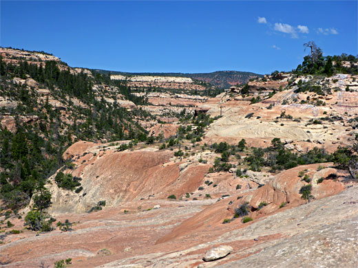
The furthest ruin is 2.8 miles from the trailhead, at which point the canyon is around 300 feet deep, though the drainage extends for another 2.5 miles, becoming deeper, narrower at stream level, and more overgrown, so there may be additional ruins upstream.
Guidelines for visiting archaeological sites
Map of Cedar Mesa, Grand Gulch and Comb Ridge.
33 views of the North Fork of Mule Canyon.
Both forks of Mule Canyon may be accessed by a wide gravel track, suitable for most vehicles including small RVs - from Hwy 95, between mileposts 101 and 102, this passes the fee station ($2 per person) and a flat area, a possible parking place for oversized vehicles, then descends into the south fork, climbs the far side and crosses a sandy flat, reaching the shallower north fork after one mile. There are several side tracks between the forks suitable for primitive camping, while the main track continues several miles to overlooks of Arch and Texas canyons. At the north fork, a short trail follows the south side of the drainage through bushes before merging with the streambed. A BLM register suggests that this canyon is visited only once every two to three days.
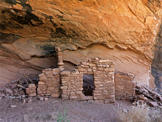
The canyon of the north fork is at first very shallow, bordered by low, earthen banks, and also quite overgrown, due to residual pools that sustain thick vegetation, but it soon widens, deepens a little and becomes less vegetated, the floor alternating between slickrock and dry sand. The streambed moves round a minor bend and enters a long straight, still quite open, but sheltered enough to sustain a few tall ponderosa pines. The first ruin, not far after the bend, is situated below a ledge very close to the streambed; it has two side walls, smoke-blackened inside, and the remains of a collapsed front wall. Nearby is a curious, projecting, narrow-stemmed formation of white sandstone enclosed in a little alcove.
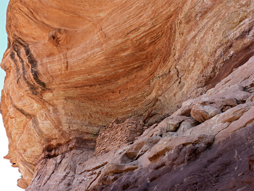
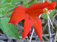
The canyon deepens only slowly, curving through a tighter, U-shaped bend and continuing past a minor north-side tributary to a larger side drainage (after 1.7 miles), also to the north, with a narrow rocky spur just west of the junction. The second ruin site is on a ledge right at the end of the spur, quite high above the streambed and so visible from some distance downstream. Here are two small granaries, one intact, the other mostly collapsed. Directly below, on the canyon floor, is an elongated seep in a shady alcove, home to a population of crimson monkeyflower, an uncommon wildflower species.
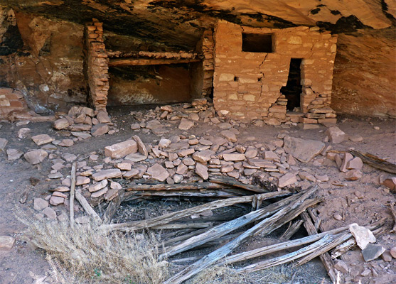
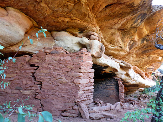
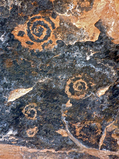
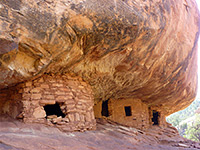
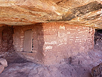
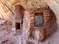
A short distance beyond the seep, and not far above the canyon floor, is the third site, consisting of two main structures, a two-room, two-level dwelling with sturdy wooden floor/ceiling, and the remains of a kiva in front, and an angular, less complete, three-room structure with fallen roof timbers. There is also at least one group of (spiral) petroglyphs, and an adobe wall panel marked with many finger prints.
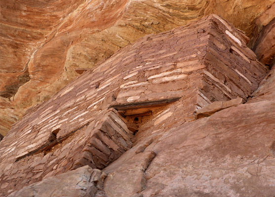
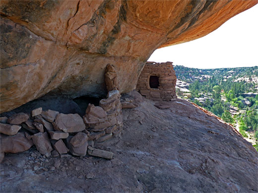
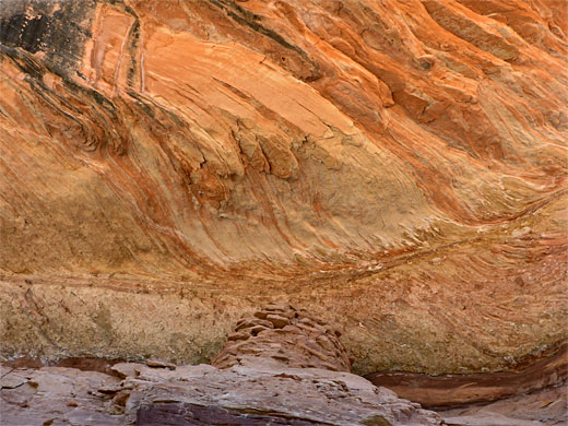
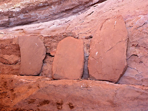
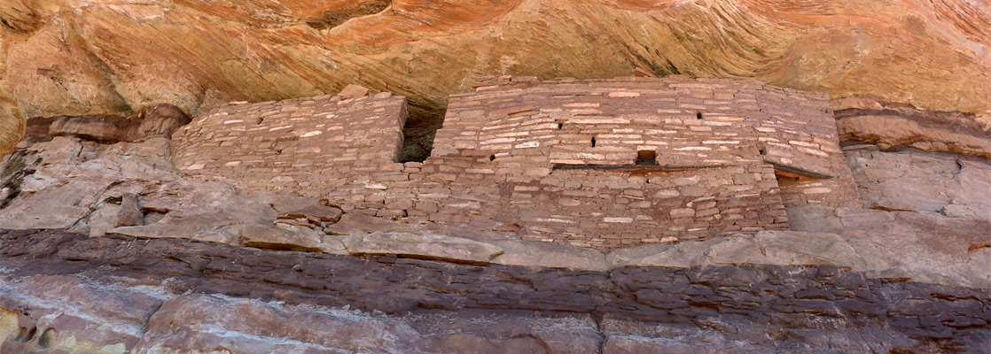
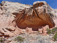
The fourth ancient site in the canyon is 0.8 miles beyond the north-side tributary, in an alcove just below the canyon rim, around 250 feet above the streambed and not so easy to reach due to steep slopes below and a near vertical cliff directly underneath. The ruin may also be approached by walking along high benches from the dual granary site. The main component is a long, two-level dwelling with neat walls, a central T-shaped doorway and a chamfered corner to one side, set below a particularly colorful, overhanging, orange-yellow cliff formed of many thin sandstone layers. Nearby are two other ruins, possibly granaries, though not, it seems, any rock art. This site affords a grand view up the canyon, over many benches and slopes of red-and-white sandstone, towards the elevated ridge of South Long Point.
The North Fork of Mule Canyon may contain a few pools and shallow streams but is usually dry, and lightly vegetated, the floor mostly wide slickrock, and there are no obstacles when walking upstream. The canyon contains four major groups of ruins - a single room close to the streambed, a pair of granaries high on a ledge, two more intricate structures in an elongated alcove, and, the largest site, a two-story dwelling and several granaries, also on a high bench. The two elevated ruins need scrambling or climbing to reach but the other two are much more accessible. All sites are on the north side of the canyon, as is usually the case, positioned to catch the morning and evening sunshine.
The furthest ruin is 2.8 miles from the trailhead, at which point the canyon is around 300 feet deep, though the drainage extends for another 2.5 miles, becoming deeper, narrower at stream level, and more overgrown, so there may be additional ruins upstream.
Guidelines for visiting archaeological sites
Location
Map of Cedar Mesa, Grand Gulch and Comb Ridge.
Photographs
33 views of the North Fork of Mule Canyon.

Mule Canyon Trailhead
Both forks of Mule Canyon may be accessed by a wide gravel track, suitable for most vehicles including small RVs - from Hwy 95, between mileposts 101 and 102, this passes the fee station ($2 per person) and a flat area, a possible parking place for oversized vehicles, then descends into the south fork, climbs the far side and crosses a sandy flat, reaching the shallower north fork after one mile. There are several side tracks between the forks suitable for primitive camping, while the main track continues several miles to overlooks of Arch and Texas canyons. At the north fork, a short trail follows the south side of the drainage through bushes before merging with the streambed. A BLM register suggests that this canyon is visited only once every two to three days.
Site 1
The canyon of the north fork is at first very shallow, bordered by low, earthen banks, and also quite overgrown, due to residual pools that sustain thick vegetation, but it soon widens, deepens a little and becomes less vegetated, the floor alternating between slickrock and dry sand. The streambed moves round a minor bend and enters a long straight, still quite open, but sheltered enough to sustain a few tall ponderosa pines. The first ruin, not far after the bend, is situated below a ledge very close to the streambed; it has two side walls, smoke-blackened inside, and the remains of a collapsed front wall. Nearby is a curious, projecting, narrow-stemmed formation of white sandstone enclosed in a little alcove.

Site 2
The canyon deepens only slowly, curving through a tighter, U-shaped bend and continuing past a minor north-side tributary to a larger side drainage (after 1.7 miles), also to the north, with a narrow rocky spur just west of the junction. The second ruin site is on a ledge right at the end of the spur, quite high above the streambed and so visible from some distance downstream. Here are two small granaries, one intact, the other mostly collapsed. Directly below, on the canyon floor, is an elongated seep in a shady alcove, home to a population of crimson monkeyflower, an uncommon wildflower species.
Site 3
A short distance beyond the seep, and not far above the canyon floor, is the third site, consisting of two main structures, a two-room, two-level dwelling with sturdy wooden floor/ceiling, and the remains of a kiva in front, and an angular, less complete, three-room structure with fallen roof timbers. There is also at least one group of (spiral) petroglyphs, and an adobe wall panel marked with many finger prints.
Site 4
The fourth ancient site in the canyon is 0.8 miles beyond the north-side tributary, in an alcove just below the canyon rim, around 250 feet above the streambed and not so easy to reach due to steep slopes below and a near vertical cliff directly underneath. The ruin may also be approached by walking along high benches from the dual granary site. The main component is a long, two-level dwelling with neat walls, a central T-shaped doorway and a chamfered corner to one side, set below a particularly colorful, overhanging, orange-yellow cliff formed of many thin sandstone layers. Nearby are two other ruins, possibly granaries, though not, it seems, any rock art. This site affords a grand view up the canyon, over many benches and slopes of red-and-white sandstone, towards the elevated ridge of South Long Point.

North Fork of Mule Canyon - Similar Hikes
All Contents © Copyright The American Southwest | Comments and Questions | Contribute | Affiliate Marketing Disclosure | Site Map