Highlights:
The largest and most numerous collection of Ancestral Puebloan ruins in the Southwest, the majority intricate cliff dwellings of up 100 or more rooms, built in alcoves beneath sheer cliffs in branched canyons cutting into a wooded sandstone plateau. Two main areas, the popular Chapin Mesa and the more remote Wetherill Mesa
Nearby town:
Cortez, 9 miles
Management:
Location:
37.340, -108.411 (park entrance)
Seasons:
April to October; all or most of the park is closed by snow at other times
Rating (1-5):
★★★★★
Weather:


Mesa Verde NP is part of the Indian Lands itinerary
Featured Hotel
Holiday Inn Express Mesa Verde-Cortez
 One of the closest hotels to Mesa Verde; 9 miles west of the park entrance on US 160, at the edge of Cortez. Free hot breakfast and an indoor pool
Check Rates
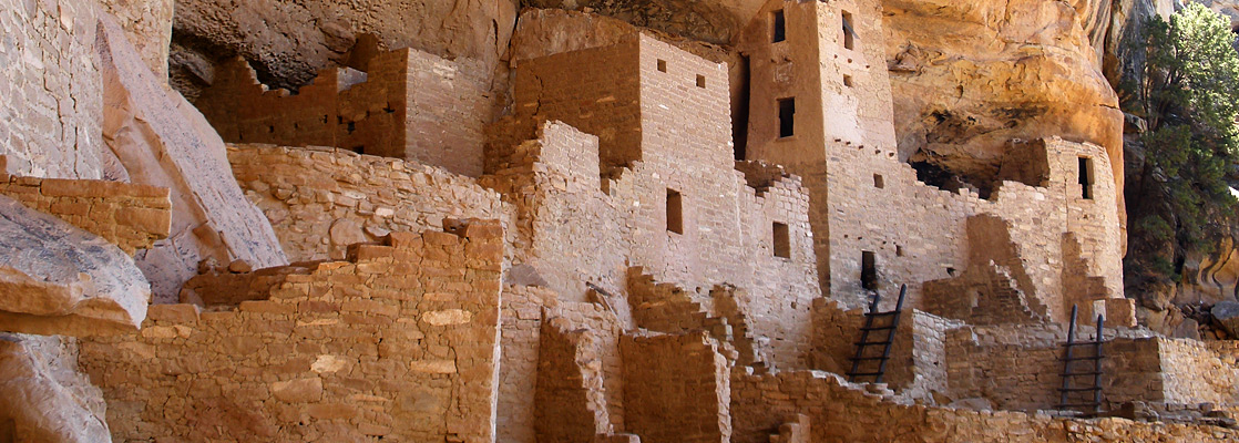
Mesa Verde is the only American national park that protects man-made structures, as opposed to natural features. In hilly, inaccessible country south of Cortez, there are over 4,000 historic ruins, many of them large structures built under steep, overhanging cliffs in narrow canyons. This is the most famous and highly visited archaeological site in the US, due to the number, the size and the excellent state of preservation of the buildings, together with their scenic location.
The park is fully open for only seven months of the year (April to October) owing to the large amount of winter snowfall received by this high elevation location - the access road runs along a ridge at over 8,000 feet. Mesa Verde is close to Four Corners, the only point where four states meet, and the center of former Indian civilisations - many other important sites are preserved nearby including Aztec Ruins, Canyon de Chelly, Chaco and Hovenweep. Today, most of the region is still within Indian reservations; the Ute in Colorado and the Navajo in AZ, NM and UT.
The park is fully open for only seven months of the year (April to October) owing to the large amount of winter snowfall received by this high elevation location - the access road runs along a ridge at over 8,000 feet. Mesa Verde is close to Four Corners, the only point where four states meet, and the center of former Indian civilisations - many other important sites are preserved nearby including Aztec Ruins, Canyon de Chelly, Chaco and Hovenweep. Today, most of the region is still within Indian reservations; the Ute in Colorado and the Navajo in AZ, NM and UT.
Mesa Verde Table of Contents
Mesa Verde Tours
Location
Map of Mesa Verde National Park.
Photographs
Chapin Mesa and the east, Wetherill Mesa.
Mesa Verde - Locations
The main location of ruins in the park, accessible all year; dozens of overlooks, several short paths, two longer trails, and three dwellings viewable on guided tours
Mesatop ruins and four large cliff dwellings in a quieter area on the west side of the park, reached by short trails; open only from spring to fall
Mesa Verde Geography
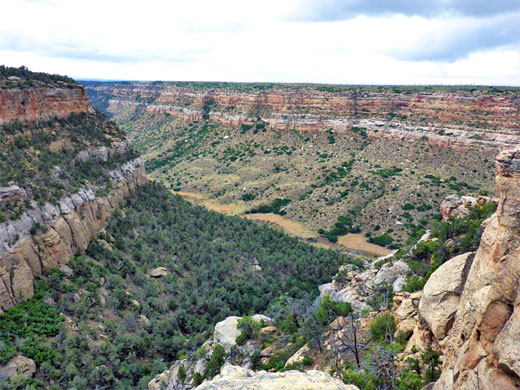
Generally, the land of extreme southwest Colorado is high desert with arid mesas and wide empty valleys, but it becomes more mountainous to the northeast, as the foothills of the San Juan Mountains approach. The hills of Mesa Verde are shaped like a comb, linked by a high ridge (the North Rim) running approximately east-west and many long thin, wooded mesas extending southwards. These have almost flat tops but are separated by narrow, often sheer-walled canyons up to 1,000 feet deep, and it was in these well-protected ravines that the Anasazi Indians built their settlements, between 550 and 1250 AD, although most of the large buildings were constructed near the end of this period. As with many other ancient cultures of the Southwest, the Mesa Verde area was abandoned quite suddenly, around 1300 AD and it was not until the late 19th century that their settlements were rediscovered.
Approach to Mesa Verde
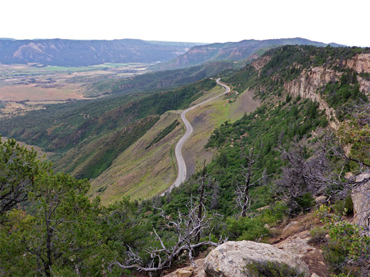
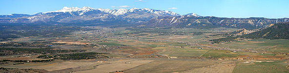
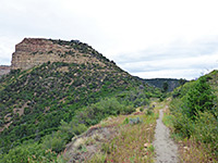
Mesa Verde National Park is approached from busy highway US 160, which runs along Montezuma Valley between Cortez and Mancos (see map). There are a few businesses including RV sites and Indian souvenir shops around the entrance, but most facilities are in the two towns, 10 and 8 miles away respectively. A steep climb begins just inside the park gate, as the road winds up a rocky ridge, reducing traffic to 15 mph in some places, and including one section right beneath a near-vertical cliff, a location prone to avalanches in winter and rockfalls all year. A pull-out on the east side gives fine views over Mancos Valley and the snow-covered La Plata Mountains, before the road passes through a gap in the ridge and onto the flat floor of Morfield Valley, site of the park's campground (open mid May to mid October). The highway crosses to the adjacent valley (Prater Canyon) via a tunnel before ascending again, steeply up to the top of North Rim, the wooded escarpment forming the south edge of Montezuma Valley. Several roadside stops allow for viewing the lands far below, and three have short trails to other viewpoints, including at Geologic Overlook and Montezuma Valley Overlook. On a clear day the views southwards extend to Shiprock Peak in New Mexico, 50 miles away.
Wildfires at Mesa Verde
Another short trail along the entrance road leads to Park Point, at 8,571 feet the highest peak in the area. Nearby stands a watch tower with uninterrupted 360 degree views, and visitors can enter to learn about the work of the fire prevention service. From here, the first signs of the great fire of August 1996 were observed - for five days, a large destructive blaze raged through the bushes and pine trees covering the hills and canyons in the north central section of Mesa Verde. The fire followed an extended spell of hot, dry weather and was started by lightning; when it was finally extinguished nearly 5,000 acres had burned, and the park had to be evacuated and closed for a week. The fire jumped across the main park road several times and spread to within a few feet of the visitor center buildings, but despite the short-term destruction, no lasting damage was done. Many other serious fires have occurred in the last hundred years, recent events being in 2000 (twice), 2002 and 2003, but the vegetation always recovers. One side effect of such fires is the revelation of previously unknown archaeological sites.
Mesa Verde Scenic Drives
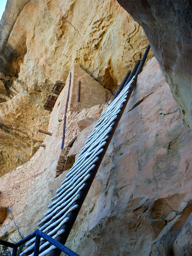
The park drive eventually reaches Far View, a cluster of buildings that includes the visitor center and a restaurant. From here, a side road (open only during summer) continues further west across steep terrain for 12 miles towards the Wetherill Mesa group of ruins, most famous of which are Long House and Step House, both large structures which may be reached by short trails. However, by far the most visited section of the park is Chapin Mesa, ten miles south of Far View along the main approach route (the Ruins Road) - here are dozens of easily accessible cliff dwellings, ruins and other historic features, although the majority of the thousands of archaeological sites in the park, many still unexcavated, are more remote. Three one-way loop systems help ease traffic congestion on the narrow roads between the various groups of ruins. There are also foot trails, but hiking is limited to recognised routes and most ruins are not open to the public, to help prevent damage to the fragile sandstone structures and the theft of artefacts. Some trails require tickets to be purchased, to control the numbers of visitors, and watchful park rangers are present at all the major ruins during opening hours. Guided tours are available through some of the largest clusters of buildings; these often require visitors to ascend ladders and crawl through small openings.
Major Sites in the National Park
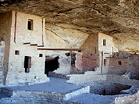
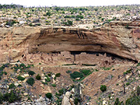
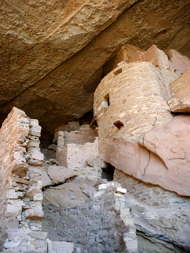
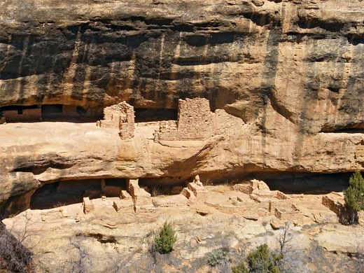
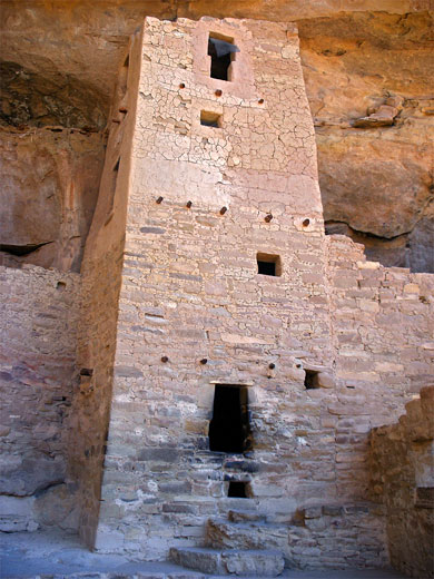
The largest cluster of buildings, with 150 rooms in total, is Cliff Palace - this has many towers, houses and circular kivas (ceremonial gathering places), is also reached by a short trail (including a ladder) and is easily explored. The palace is best viewed from a different road at the opposite side of the canyon. Spruce Tree House, one of the best-preserved cliff house complexes, is visible from the road near the park museum. The structure originally had 114 separate rooms and is built in a large overhanging cave-like recess in the canyon wall. A short but quite steep foot trail descends into Spruce Tree Canyon to view the ruins; however, the site is currently closed to the public 'for the foreseeable future' following a 2015 rock fall, and concerns over the stability of parts of the overhanging walls. A longer path (the 2.4 mile Petroglyph Point Trail) continues past, and along the canyon, giving a good appreciation of the landscape - it passes colorful rock formations and several small ruins as well as the petroglyphs. The trail returns along the rim above the canyon with good views of distant lands to the west. The third large ruin in the Chapin Mesa area is Balcony House, visible further along the Cliff Palace loop road.
Ruins and Sites on Chapin Mesa
Ruins and Sites on Wetherill Mesa
Trails of Mesa Verde
All Mesa Verde trails
Featured Mesa Verde Trails
Knife Edge Trail
★★★★★
★★★★★
1 mile, 60 feet
Easy walk along an old roadbed, through a low pass and across a steep slope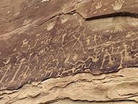
Petroglyph Point Trail
★★★★★
★★★★★
2.9 miles, 300 feet (loop)
Path along the canyon south of Spruce Tree House, to a large petroglyph panel, returning on the mesa top close to the canyon rim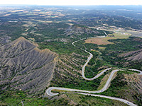
Point Lookout Trail
★★★★★
★★★★★
1.1 miles, 530 feet
Short but quite steep trail to an 8,427 foot summit overlooking the north edge of the national park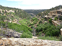
Spruce Canyon Trail
★★★★★
★★★★★
2.4 miles, 550 feet (loop)
Loop along part of a wooded canyon, reached from the rim via two short tributariesMesa Verde Wildflowers
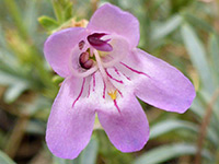
Photographs and descriptions of flowering plants found in the national park
Mesa Verde - Nearby Places
- Aztec Ruins National Monument, New Mexico (67 miles) - well preserved settlement from the 12 century
- Hovenweep National Monument (50 miles) - remote ruins on the Utah-Colorado border
- Shiprock, New Mexico (67 miles) - stark volcanic peak in the high desert
Mesa Verde - Similar Places
- Bandelier National Monument, New Mexico - unusual cliff dwellings and ruins in a volcanic canyon
- Canyons of the Ancients National Monument, Colorado - thousands of ancient sites, most unmarked and unrestored
- Walnut Canyon National Monument, Arizona - ancient ruins in a deep canyon near Flagstaff
All Contents © Copyright The American Southwest | Comments and Questions | Contribute | Affiliate Marketing Disclosure | Site Map