The Mesa Verde National Park map indicates the location of all open trails.

Mesa Verde Trails
Badger House Community Trail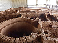 Length 1.2 miles (1.9 km) Elevation change 130 feet (40 meters) Trailhead End of the road to Wetherill Mesa. Also accessed from several places along the tram route Rating (1-5) ★★★★★ The ruins of Badger House comprise four mesa top sites, all now protected by metal enclosures. A trail visits the ruins, accessed from several places along the Wetherill Mesa tram route, and linked by a longer path from the end of the approach road. The shortest hike to see all sites is 0.6 miles. |
|
Farming Terrace Trail Length 0.5 miles (0.8 km) (loop) Elevation change 120 feet (37 meters) Trailhead Along the road to Cedar Tree Tower Rating (1-5) ★★★★★ The remains of several ancient check dams are visited by this short loop trail, which descends slightly into a shallow ravine then returns across the flat lands above. |
Knife Edge Trail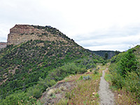 Length 1 miles (1.6 km) Elevation change 60 feet (18 meters) Trailhead Parking lot near Morfield Campground Rating (1-5) ★★★★★ Easy walk along an old roadbed, through a low pass then gently down across a steep slope, with long distance views across Montezuma Valley towards Sleeping Ute Mountain. A good selection of summer wildflowers may be seen along the way, and the final viewpoint is a good place to watch the setting sun. |
Nordenskiold Site 16 Trail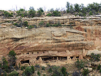 Length 0.8 miles (1.3 km) Elevation change 90 feet (27 meters) Trailhead Along the Wetherill Mesa tram route Rating (1-5) ★★★★★ An otherwise inaccessible ruin is viewed from an overlook on the east rim of Rock Canyon, reached by a short trail across the mesa top, which is level at first then descends slightly towards the end. |
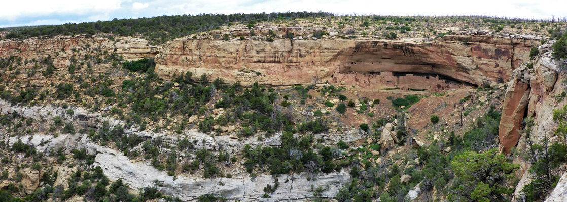
Petroglyph Point Trail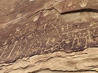 Length 2.9 miles (4.7 km) round trip Elevation change 300 feet (91 meters) Trailhead Parking lot beside Chapin Mesa Museum Rating (1-5) ★★★★★ Starting at the cliff dwelling ruins of Spruce Tree House, this trail heads downstream along the canyon, giving a good appreciation of the landscape, passing colorful rock formations and another small ruin as well as a set of petroglyphs. The path later climbs to the rim above the canyon and returns along the plateau, with views of distant lands to the west. |
Point Lookout Trail Length 1.1 miles (1.8 km) Elevation change 530 feet (162 meters) Trailhead North side of Morfield Campground Rating (1-5) ★★★★★ Point Lookout, an 8,427 foot summit, overlooks the north part of the national park entrance road, as well as vast areas of the surrounding countryside, including Mancos Valley and Montezuma Valley. The short trail to the top climbs steeply from Morfield Campground then traverses nearly level terrain to the viewpoint. |
|
Prater Ridge Trail Length 7.8 miles (12.6 km) (loop) Elevation change 700 feet (213 meters) Trailhead Along the spur road to Morfield Campground Rating (1-5) ★★★★★ This rather long trail loops all around the edge of the bushy mesa west of Morfield Campground, passing no ruins but offering views in all directions. The elevation gain is all at the start; the remainder of the hike is mostly level, over slickrock and grassland along the rim. A cut off trail divides the north and south sections of the loop, allowing shorter round trips of 5.5 or 3.5 miles respectively. |
Soda Canyon Overlook Trail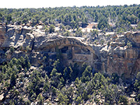 Length 0.6 miles (1 km) Elevation change 40 feet (12 meters) Trailhead Pull-out along the Cliff Palace Loop Road Rating (1-5) ★★★★★ Soda Canyon Overlook Trail winds through wooded surroundings, around the head of a side ravine and on to a viewpoint on the rim of a much larger canyon, opposite the ruins of Balcony House - the only location where these may be viewed. Other, more distant ruins are visible further downstream. |
Spruce Canyon Trail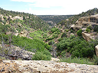 Length 2.4 miles (3.9 km) (loop) Elevation change 550 feet (168 meters) Trailhead Chapin Mesa Museum Rating (1-5) ★★★★★ Spruce Canyon borders Chapin Mesa to the west, and may be explored by a loop trail that while not coming close to any ruins does pass within sight of a few cliff dwellings high up on the far side. The path starts by Spruce Tree House, following the first part of the Petroglyph Point Trail then forking off to the west, leading up Spruce Canyon for a mile then climbing back to the mesa. |
Step House Trail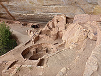 Length 0.8 miles (1.3 km) (loop) Elevation change 90 feet (27 meters) Trailhead End of the road to Wetherill Mesa Rating (1-5) ★★★★★ The ruins of Step House sit in an alcove at the upper end of a short tributary of Long Canyon; they may be viewed by a self-guided loop trail that drops down quite steeply, passes in front of the site then climbs back to the mesa top. |
Wetherill Mesa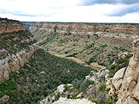 Length 5.2 miles (8.4 km) (loop) Elevation change 200 feet (61 meters) Trailhead End of the road to the mesa Rating (1-5) ★★★★★ Apart from the quick walk to Step House, the accessible ancient sites of Wetherill Mesa are accessed by short paths off the old tram road, now closed to all vehicles: overlooks of Kodak House, Long House and Nordenskiold Site 16, and the mesa top ruins of Badger House. These may be visited individually, or along a 5.2 mile loop, the furthest reaches of which (around Kodak House) are very lightly traveled. |
All Contents © Copyright The American Southwest | Comments and Questions | Contribute | Affiliate Marketing Disclosure | Site Map