Highlights:
Detached unit of Canyonlands National Park, west of the main section - several miles of a deep, vertical-walled canyon, a tributary of the Green River, containing four major pictograph panels, some of finest rock art in the Southwest. Reached by unpaved roads and a 3 mile hike
Location:
38.473, -110.200 (trailhead parking)
Seasons:
All year

Twenty miles northwest of the Maze, the Horseshoe Canyon section of Canyonlands National Park features a deep, vertical-walled ravine similar to many others in the neighborhood, but the main attraction here are four ancient Indian pictograph panels including the Great Gallery, a collection of several dozen figures reckoned to be the best rock art of its type anywhere on the Colorado Plateau. This part of the national park is small, enclosing just 5 miles of the canyon and a narrow belt of land on either side, and also quite remote, first requiring a trip on unpaved roads of at least 31 miles.
The four sets of pictographs may then be visited by a moderately difficult 3.25 mile trail that drops 600 feet from the canyon rim and follows the dry wash upstream, usually across soft sand that makes the walk quite tiring, especially during the summer months when the temperatures routinely top 100°F. Several dozen visitors make the trip each day in the popular seasons of spring and fall, and are rewarded by close up views of hundreds of large, elaborate, well preserved pictographs, all with comparatively easy access. There are countless other pictograph locations in Southwest canyons but the majority are more difficult to reach.
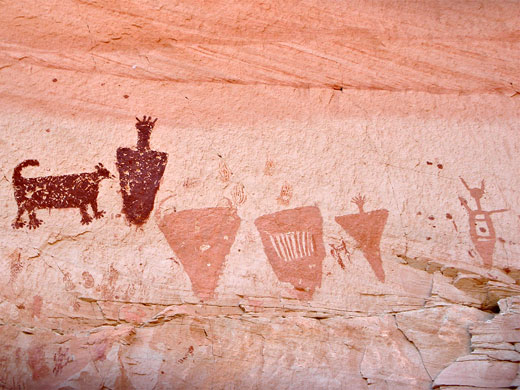
Horseshoe Canyon was originally known as Barrier Canyon, and the pictographs here are the type-example for the Barrier Canyon Style, chracterized by use of large areas of solid color, especially for anthropomorphic figures, detailed and varied designs, and association with animals.
The four sets of pictographs may then be visited by a moderately difficult 3.25 mile trail that drops 600 feet from the canyon rim and follows the dry wash upstream, usually across soft sand that makes the walk quite tiring, especially during the summer months when the temperatures routinely top 100°F. Several dozen visitors make the trip each day in the popular seasons of spring and fall, and are rewarded by close up views of hundreds of large, elaborate, well preserved pictographs, all with comparatively easy access. There are countless other pictograph locations in Southwest canyons but the majority are more difficult to reach.
Horseshoe Canyon was originally known as Barrier Canyon, and the pictographs here are the type-example for the Barrier Canyon Style, chracterized by use of large areas of solid color, especially for anthropomorphic figures, detailed and varied designs, and association with animals.
Horseshoe Canyon Table of Contents
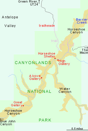
Map of Horseshoe Canyon
Photographs
13 views of Horseshoe Canyon.
History
Pictographs were created by painting onto rocks using pigments made from powdered minerals, and are less common (partly as they are more susceptible to damage by erosion) than petroglyphs, which are produced by chipping away the weather-darkened surface of the rock to reveal lighter stone underneath. In the Canyonlands area, the best petroglyph panel is at Newspaper Rock along UT 211. The largest designs at Horseshoe Canyon date from the Late Archaic period of 2,000 BC to 500 AD, with later additions by the Fremont and Ancestral Pueblo cultures.
Approach Roads to Horseshoe Canyon
Access to Horseshoe Canyon is along an unpaved but fairly well maintained road starting either at Green River or UT 24 (near milepost 136); this latter is easiest, a 29 mile journey eastwards across wide open land of the San Rafael Desert. See the description of the approach to the Moonshine Wash slot canyon for a fuller account of the two routes. The spur to the national park is a narrower road of 2 miles, still fine for all vehicles though the last part does have a few steep and rocky places. It ends at a large, lonely parking area by the edge of the plateau, from where several miles of canyon are in view, together with other more distant cliffs and ravines towards the Green River. The trailhead is unstaffed and furnished just with rest rooms and an information board plus map, though park rangers visit regularly and often make the hike to the pictographs. Camping is permitted by the trailhead (which is on BLM land outside the national park), or along side tracks away from the main approach road, but all the land is flat, open and treeless so there are not many nice sites. All roads in this area are liable to become impassable for a while after heavy rain.

Horseshoe Canyon Trail
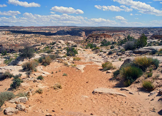
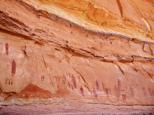
The 3 mile path sets off over a slope of grayish slickrock, well marked by cairns, and quite winding so that the downwards gradient is not too steep. It soon reaches the top of the vertical cliffs at the edge of the main ravine, passes through an NPS gate marking the park boundary then descends to the canyon floor via a long, curving section across a large sand hill - quite a tiring climb on the return journey. The plateau may be cool and windy but conditions are usually quite different at the stream level, as the high walls block the wind, the temperature increases, and for much of the year the place is bone dry. A 4WD track climbs the far side of the canyon and links with the Maze district of Canyonlands, while the trail turns south (upstream), along the wide, flat sandy floor. Cairns indicate the recommended route but it is sometimes better to veer off to one side for firmer footing. A few places are permanently moist because of small seeps, where shallow water flows a short distance and allows willow and larger cottonwood trees to flourish; all of the canyon is wide enough to support a variety of bushes and desert plants, growing on high sandbanks either side of the drainage channel. The walls are smooth Navajo sandstone, typically light brown colored, streaked with dark bands of desert varnish, and often eroded at stream level on the outside of bends into big alcoves where some of the pictographs are found, protected from sun and rain. Horseshoe Canyon is formed by Barrier Creek, a long, branched drainage whose upper forks include the Blue John slot canyon; indeed, trips through this canyon can be combined with the trail past the pictographs for a total hike of around 15 miles (rappelling equipment and car shuttle required).
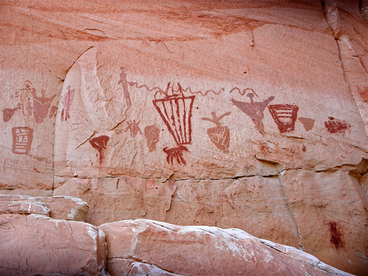
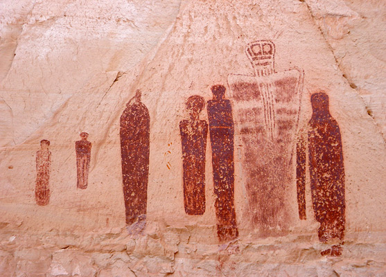
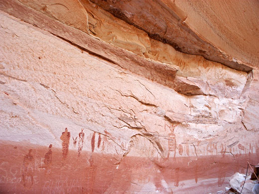
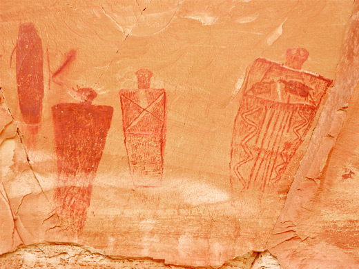
The Horseshoe Canyon Pictographs
The first pictographs are at the High Gallery, on the east side of the canyon, reached by a short side path that climbs a sandy slope to the base of the cliffs. The images are rather indistinct, and situated 20 feet above the ground so were presumably painted by people standing on several very narrow ledges that slant across this part of the cliffs. The second location is Horseshoe Shelter, nearly opposite on the west side; this has more simple figures but they are much crisper, and painted on a band of rock almost white in color so they stand out very well. The third group, perhaps the least impressive, is the Alcove Gallery found in a particularly large overhang on the west side of the canyon, 2 miles from the start. The pictographs are somewhat faded and damaged by 20th century graffiti. The final panel, and by far the grandest is the Great Gallery, at the end of the trail after 3.25 miles. This is also on the west side, in a shallower alcove, and it contains dozens of detailed, mysterious, intricate pictures in various shades of red and brown, some up to 8 feet tall and extending across the canyon walls for over 200 feet. Most are in excellent condition; just a few are incomplete owing to collapse of part of the cliff face. Many are the familiar ghostly armless effigies (anthropomorphs), often bearing intricate decoration on the upper torso, but others include animals, hunters and more abstract shapes. Petroglyphs as well as pictographs are found here. The panel is protected by a fence though most figures are 10 feet or more above ground level and so high enough to avoid casual visitor damage. The NPS state the 6.5 mile round trip to the Great Gallery takes 4 to 6 hours but it can be done in as little as 2.5 hours.
All Contents © Copyright The American Southwest | Comments and Questions | Contribute | Affiliate Marketing Disclosure | Site Map