Lower Mule Canyon
Downstream end of a long drainage on the east side of Cedar Mesa, containing several groups of Ancestral Puebloan ruins, easily accessed from Comb Wash Road
Length: 1 mile
Elevation change: 100 feet
Difficulty: Easy
Type: One way, along a trail
Usage: Low to medium
Season: All year
Trailhead: End of a very short track west of Comb Wash Road, or along the road itself
Rating (1-5): ★★★★★
Elevation change: 100 feet
Difficulty: Easy
Type: One way, along a trail
Usage: Low to medium
Season: All year
Trailhead: End of a very short track west of Comb Wash Road, or along the road itself
Rating (1-5): ★★★★★

At the east edge of Cedar Mesa, the land slopes gently down to the wide valley of Comb Wash, which is bordered on the far side by the much steeper west face of Comb Ridge. An unpaved but good quality track - a designated county road - runs all through the valley, giving access to the lower end of several major tributary canyons, most of which contain Anasazi ruins. These tend to be concentrated towards the upper end of the drainages, and many of the best sites are reached from UT 261 across the high part of the mesa, but some places have ruins near the lower end, such as Mule Canyon, which is the first tributary encountered when driving south along Comb Wash Road, one mile from Hwy 95.
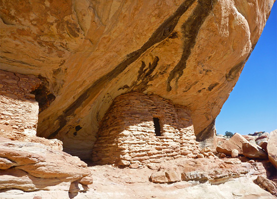
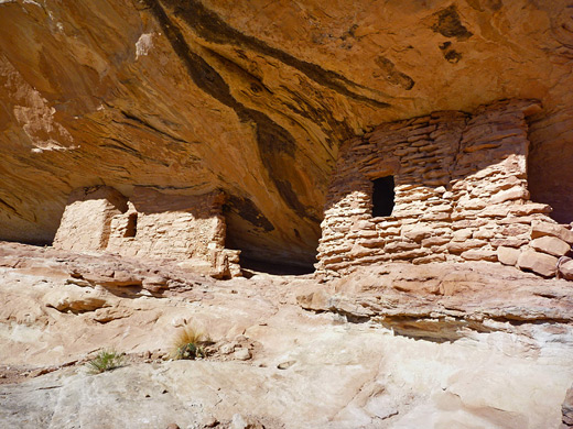
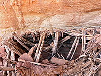
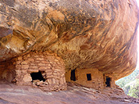
A hike of just less than a mile leads to two groups of ruins, not too large but attractively situated in sandstone alcoves, beneath cliffs that have nicely eroded surface textures and are streaked with dark patterns of desert varnish. The parking area for the hike is also a good place to camp, shaded by tall cottonwood trees.
Guidelines for visiting archaeological sites
Map of Cedar Mesa, Grand Gulch and Comb Ridge.
The Lower Mule Canyon trailhead is 1 mile south of Hwy 95 on Comb Wash Road (17 miles north of US 163) then a short distance west on a narrow track, which leads to an open area beside a line of cottonwood trees that border the (usually dry) wash emerging from Mule Canyon. A sandier track continues, briefly north and then west, alongside the wash through shady woodland with a varied selection of wildflowers including Indian paintbrush, coral gilia and flaxflowered gilia.
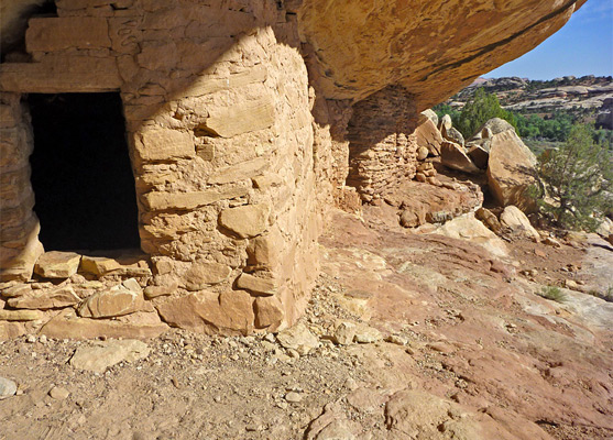
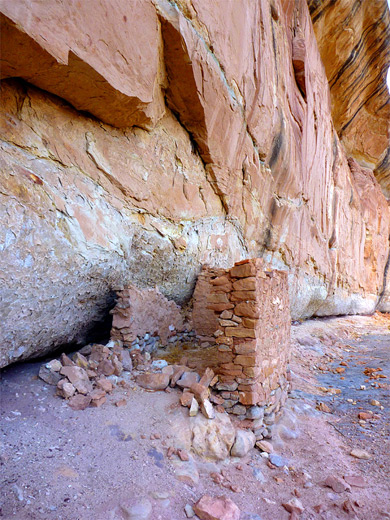
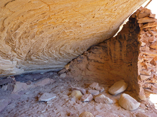
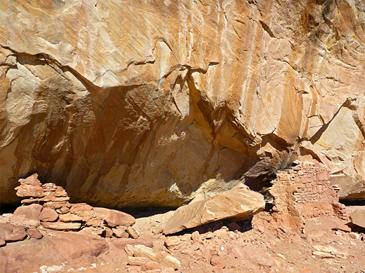
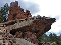
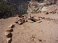
The first ruins come into view quite soon, not much more than half a mile from the parking area, in a little basin on the north side of the canyon, soon after the cliffs start to rise up. An ATV track leads most of the way there, climbing a little towards the base of the cliffs. This first site is in two parts, above a white sandstone layer, reached by climbing about 50 feet up a steep slope. The ruins include several rooms and wall remnants, plus some faded petroglyphs. The next ancient site is not far beyond, also on the north side, past a narrow line of protruding rocks, on top of a white bench. Again some climbing is needed. This site has just one recognizable room, plus two soot-blackened areas where fires were once lit. As is often the case with Anasazi ruins, there are many small pot fragments scattered about, and also pieces of sharp-edged, flint-like minerals, perhaps used by the Anasazi to make tools. The two sites seem quite popular, judging by the number of footprints and tire tracks in the parking area. Upstream, the canyon becomes a lot deeper but does not appear to have any major ruins for several miles. The upper reaches of the canyon are easily accessed from UT 95, and the South Fork in particular has many good sites.
A hike of just less than a mile leads to two groups of ruins, not too large but attractively situated in sandstone alcoves, beneath cliffs that have nicely eroded surface textures and are streaked with dark patterns of desert varnish. The parking area for the hike is also a good place to camp, shaded by tall cottonwood trees.
Guidelines for visiting archaeological sites
Location
Map of Cedar Mesa, Grand Gulch and Comb Ridge.
Mule Canyon Access
The Lower Mule Canyon trailhead is 1 mile south of Hwy 95 on Comb Wash Road (17 miles north of US 163) then a short distance west on a narrow track, which leads to an open area beside a line of cottonwood trees that border the (usually dry) wash emerging from Mule Canyon. A sandier track continues, briefly north and then west, alongside the wash through shady woodland with a varied selection of wildflowers including Indian paintbrush, coral gilia and flaxflowered gilia.
The Ruins
The first ruins come into view quite soon, not much more than half a mile from the parking area, in a little basin on the north side of the canyon, soon after the cliffs start to rise up. An ATV track leads most of the way there, climbing a little towards the base of the cliffs. This first site is in two parts, above a white sandstone layer, reached by climbing about 50 feet up a steep slope. The ruins include several rooms and wall remnants, plus some faded petroglyphs. The next ancient site is not far beyond, also on the north side, past a narrow line of protruding rocks, on top of a white bench. Again some climbing is needed. This site has just one recognizable room, plus two soot-blackened areas where fires were once lit. As is often the case with Anasazi ruins, there are many small pot fragments scattered about, and also pieces of sharp-edged, flint-like minerals, perhaps used by the Anasazi to make tools. The two sites seem quite popular, judging by the number of footprints and tire tracks in the parking area. Upstream, the canyon becomes a lot deeper but does not appear to have any major ruins for several miles. The upper reaches of the canyon are easily accessed from UT 95, and the South Fork in particular has many good sites.

Lower Mule Canyon - Similar Hikes
All Contents © Copyright The American Southwest | Comments and Questions | Contribute | Affiliate Marketing Disclosure | Site Map