Highlights:
Ruins, rock art and red rock scenery along a relatively shallow Colorado Plateau canyon east of Blanding, toured by a 43 mile gravel road, suitable for all vehicles. Several dozen ancient sites, and more along side canyons
Management:
Location:
37.564, -109.252 (Three Kiva Pueblo)
Seasons:
All year, though hot in summer, and affected by snow in winter
Rating (1-5):
★★★★★
Weather:


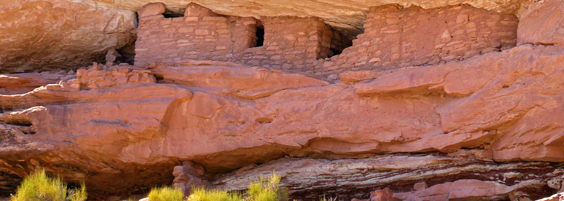
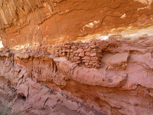
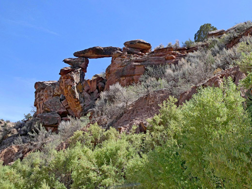
Montezuma Creek is a lengthy, north-side tributary of the San Juan River in southeastern Utah, a seasonal drainage enclosed by a relatively wide, branched canyon through red and white rocks of the Morrison Formation, up to 1,200 feet deep towards its upper (north) end. The canyon walls have many alcoves, stretches of sheer cliffs and photogenic eroded formations, but like many ravines in this part of the state the main attractions are the ancient sites - cliff dwellings, granaries and rock art, with several dozen locations all along the main drainage, and more in its tributaries.
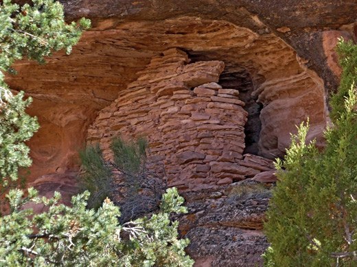
One site, Three Kiva Pueblo, has been stabilized, and includes a fully restored kiva which may be entered, but apart from this all ruins are unmarked and unmodified. Some are quite high in alcoves and so hard to see close-up yet the majority are easily viewed and accessed, by short walks from the road through the canyon, which is unpaved though usually suitable for all vehicles.
One site, Three Kiva Pueblo, has been stabilized, and includes a fully restored kiva which may be entered, but apart from this all ruins are unmarked and unmodified. Some are quite high in alcoves and so hard to see close-up yet the majority are easily viewed and accessed, by short walks from the road through the canyon, which is unpaved though usually suitable for all vehicles.
Montezuma Canyon Table of Contents
- Map of Montezuma Canyon
- Photographs
- Montezuma Canyon Road
- Sites in the North
- Devil Canyon to Bradford Canyon
- Sites in the South
- Nearby places
- Similar places
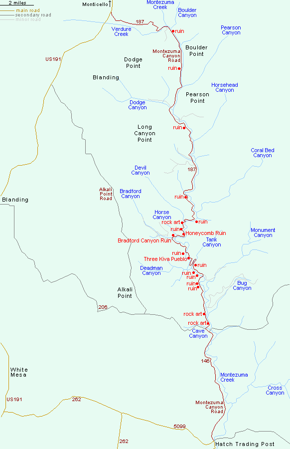
Map of Montezuma Canyon
Introduction
Montezuma Canyon is largely surrounded by public (BLM) land and is only sparsely inhabited, with various places suitable for primitive camping. The only extended private area is on the west side stretching about ten miles, approximately along the middle third. The winding road through the canyon is 43 miles long, with most of the ruins and rock art within an 11 mile section between the tributaries of Cave Canyon and Devil Canyon; further north are some lesser ruins, more spread out, while to the south there appear to be no ancient sites.
At least one full day could be spent if exploring in depth, or just a few hours for the (four) major sites, which are a group of rock art panel panels near Cave Canyon, the Three Kiva Pueblo, an extensive settlement at the mouth of Bradford Canyon, and the nearby Honeycomb Ruin.
Montezuma Canyon Road
The road through Montezuma Canyon starts in the south at Hatch Trading Post (permanently closed) by the junction with road 5099 to Hovenweep, and in the north at an intersection with US 191, three quarters of the way from Blanding to Monticello. The most direct access from Blanding, to the lower end of the main area of ruins, is via road 206 (20 miles). The main road is described below from north to south.
Sites in the North
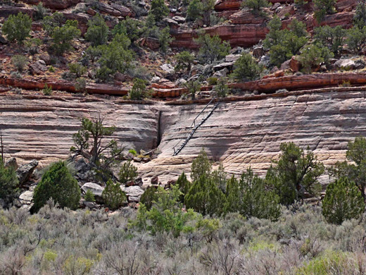
From US 191, Montezuma Canyon Road (CR187) heads east a short distance before a steep descent into the side canyon of Verdure Creek to the floor of the main valley, here about one thousand feet wide. The first obvious ruin is on the east side just south of Boulder Canyon, near the remains of an old homestead, while not far beyond is a huge alcove in a steep red cliff, with a line of moqui steps leading up to it. Near here are a couple of homes built into huge alcoves, and a small roadside ruin, followed after a short distance by an aged wooden ladder along a steep rock slope, once used to access the bench above - this on the west side of the canyon.
Devil Canyon to Bradford Canyon
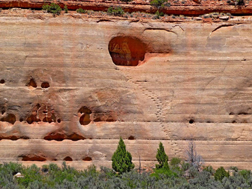
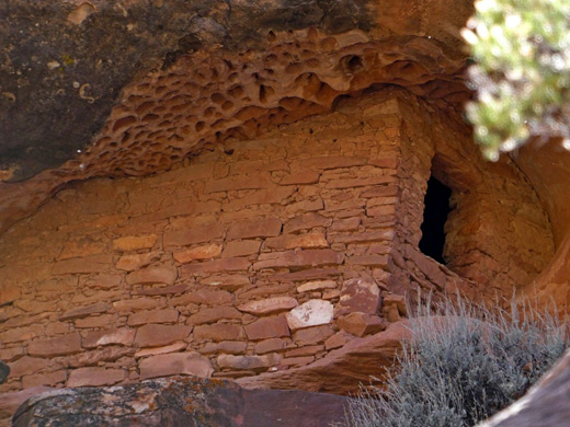
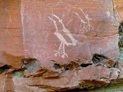
Over the next few miles are several minor ruins, before the more concentrated group, beginning just south of Devil Canyon, the first place of interest being several petroglyph panels, one depicting a hand and a god-like figure, the other a group of shapes and effigies. 0.4 miles south is a granary, partly hidden by trees, then a similar distance further is Honeycomb Ruin, named for the potholed texture of its alcove roof. This structure is about 50 feet above the road, clearly visible from below. South of Honeycomb Ruin, the road bends sharply to the west, past Horse Canyon to the mouth of Bradford Canyon, and just before this drainage is the largest pueblo in Montezuma Canyon, the Bradford Canyon Ruins, consisting of a dozen or more structures on several levels, plus both pictographs and petroglyphs. The site is easily reached from the road.
Sites in the South
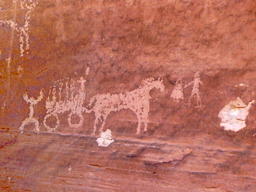
Two miles south of Bradford Canyon, a short track heads southwest towards the base of a cliff below a pair of granaries, then less than a mile further, the road reaches the Three Kiva Pueblo, the restored site, complete with intact kiva. Soon after here the road switchbacks sharply to cross the eastern tributary of Tank Canyon, after which are four more ancient sites, all on the west side; a rather hidden ruin with two white shield petroglyphs, a smaller ruin, another minor ruin accompanied by some larger pictographs (including a spiral, a pair of feet and a four-limbed figure), and finally a wall fragment beside more petroglyphs, most notably a covered wagon, a deer, and several human figures with white outlines. The latter two sites are very close together, along a track. The southernmost major location in Montezuma Canyon is half a mile north of the junction with CR 206, on the north side of a protruding cliff - here is a group of rock art panels extending nearly a quarter of a mile, with many human figures, animals (including sandhill cranes) and geometric shapes.
Montezuma Canyon - Nearby Places
- Comb Ridge (33 miles) - numerous petroglyphs, pictographs and Ancestral Puebloan ruins
- Hovenweep National Monument (16 miles) - ruins of 13th century villages
Montezuma Canyon - Similar Places
- Molen Seep, Utah - red pictographs in the San Rafael Swell
- Nine Mile Canyon, Utah - thousands of ancient petroglyphs
- Sego Canyon, Utah - pictograph panels in the Book Cliffs, plus an abandoned mining settlement
All Contents © Copyright The American Southwest | Comments and Questions | Contribute | Affiliate Marketing Disclosure | Site Map