Molen Seep
Minor drainage along the west edge of the San Rafael Swell lined by low cliffs of Ferron Sandstone, adorned with panels of intricate red pictographs, and a few petroglyphs
Length: 0.3 miles
Elevation change: 110 feet
Difficulty: Easy
Type: One way, off-trail
Usage: Low
Season: All year, but not during wet or icy weather
Trailhead: County road 706, 11 miles from Ferron
Rating (1-5): ★★★★★
Elevation change: 110 feet
Difficulty: Easy
Type: One way, off-trail
Usage: Low
Season: All year, but not during wet or icy weather
Trailhead: County road 706, 11 miles from Ferron
Rating (1-5): ★★★★★

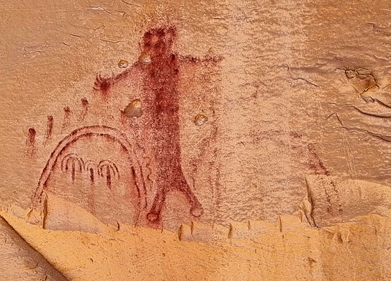
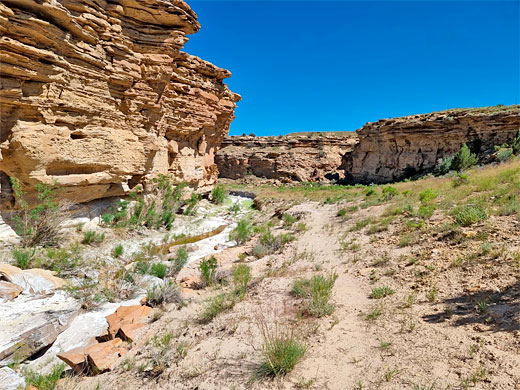
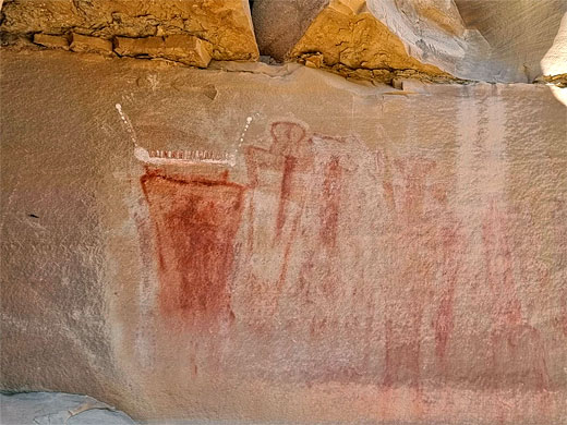
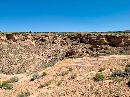
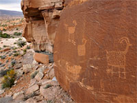
Molen Seep is a minor drainage on the west side of the San Rafael Swell, starting in the foothills of Manti La Sal National Forest, crossing a wide valley (Dutch Flat), then cutting through a low plateau, the Molen Reef, formed of buff-colored Ferron Sandstone. It forms a three mile-long canyon through the reef, at most 200 feet deep, and is of interest for several panels of petroglyphs and pictographs, concentrated along the lower half mile, at the west end of the canyon.
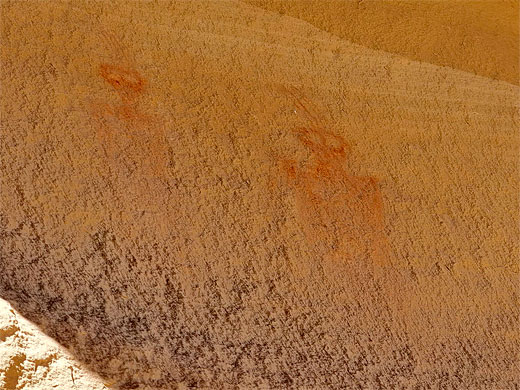
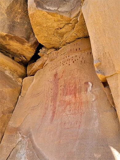
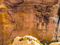
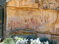
This place is reached by driving 4.5 miles on unpaved roads, gravel or clayish, suitable for most vehicles when dry; the rock art is all along the north side of the canyon, viewed on an easy hike of around half a mile, round-trip. The best designs are the pictographs, mostly red with some white components, some rather faded most quite intricate and detailed. These are typical examples of the Barrier Canyon Style, which is concentrated in the Swell and in Canyonlands National Park.
Guidelines for visiting archaeological sites
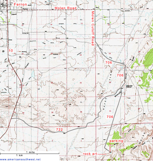
Molen Seep is reached from Hwy 10 near Ferron; the usual route is east 3 miles along 1000 S (Molen Road), south for 2.5 miles on Molen Cutoff Road as the surface changes to gravel, then further south, for 3 miles, on CR 706 and finally 1000 feet east on a side track, ending at a little loop on the north rim of the canyon, 100 feet deep at this point. An alternative approach begins 4 miles south on Hwy 10; 5 miles east on CR 722 (Ferron Old Dump Road) which intersects CR 706, then south as before.
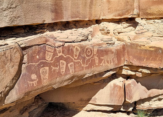
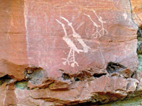
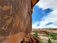
Below the parking place are some sheer cliffs but also a few gaps, and one in particular allows a relatively simple climb down to the streambed. An alternative is to walk a quarter of a mile west along the rim, since this slopes gently down towards the canyon mouth. If descending from the parking place, all the rock art is to the west; first are some petroglyphs including one distinctive panel quite high up featuring a snake and some filled circles, another panel lower down, this containing lines, animals, a circular bull's-eye and a group of sandals. A short distance further is the main attraction, the collection of pictographs, some elements of which, those most exposed to the sun, are somewhat faded, while other parts are still crisp. All the best pictographs and petroglyphs are found across one short section of the cliffs, around 500 feet.
This place is reached by driving 4.5 miles on unpaved roads, gravel or clayish, suitable for most vehicles when dry; the rock art is all along the north side of the canyon, viewed on an easy hike of around half a mile, round-trip. The best designs are the pictographs, mostly red with some white components, some rather faded most quite intricate and detailed. These are typical examples of the Barrier Canyon Style, which is concentrated in the Swell and in Canyonlands National Park.
Guidelines for visiting archaeological sites
Access
Molen Seep is reached from Hwy 10 near Ferron; the usual route is east 3 miles along 1000 S (Molen Road), south for 2.5 miles on Molen Cutoff Road as the surface changes to gravel, then further south, for 3 miles, on CR 706 and finally 1000 feet east on a side track, ending at a little loop on the north rim of the canyon, 100 feet deep at this point. An alternative approach begins 4 miles south on Hwy 10; 5 miles east on CR 722 (Ferron Old Dump Road) which intersects CR 706, then south as before.
The Rock Art
Below the parking place are some sheer cliffs but also a few gaps, and one in particular allows a relatively simple climb down to the streambed. An alternative is to walk a quarter of a mile west along the rim, since this slopes gently down towards the canyon mouth. If descending from the parking place, all the rock art is to the west; first are some petroglyphs including one distinctive panel quite high up featuring a snake and some filled circles, another panel lower down, this containing lines, animals, a circular bull's-eye and a group of sandals. A short distance further is the main attraction, the collection of pictographs, some elements of which, those most exposed to the sun, are somewhat faded, while other parts are still crisp. All the best pictographs and petroglyphs are found across one short section of the cliffs, around 500 feet.
Topo Map of Molen Seep
Molen Seep - Similar Hikes
All Contents © Copyright The American Southwest | Comments and Questions | Contribute | Affiliate Marketing Disclosure | Site Map