Hidden Valley Trail
Path up a steep, boulder-covered slope with great views of Moab and the La Sal Mountains, then along the flat, grassy floor of a sheltered valley below red rock cliffs, to a major petroglyph site
Length: 2.5 miles
Elevation change: 700 feet
Difficulty: Moderate; steep at the start
Type: One-way
Usage: Medium
Season: All year
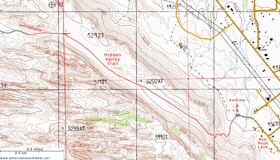
Trailhead: End of a short track off Rim Rock Lane, 4 miles from downtown Moab
Rating (1-5): ★★★★★
Elevation change: 700 feet
Difficulty: Moderate; steep at the start
Type: One-way
Usage: Medium
Season: All year
Trailhead: End of a short track off Rim Rock Lane, 4 miles from downtown Moab
Rating (1-5): ★★★★★

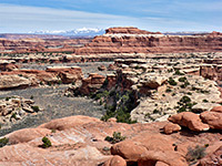
The Hidden Valley Trail is a popular route in the red rock country southwest of Moab, just four miles from the town center, served by a maintained trailhead at the end of a short gravel track, off a residential street close to US 191. The valley is an example of a graben, a sunken area of land between two parallel normal faults, and it has formed little way up the dramatic red cliffs that border the highway to the west.
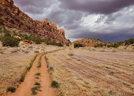
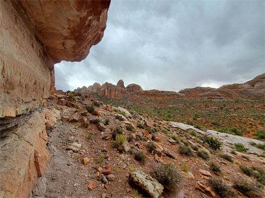
The valley is lined to the east by relatively low cliffs of the Kayenta Formation, and on the other side by a short band of the Kayenta beneath a much taller exposure of Navajo sandstone, and when viewed from the highway below is essentially hidden, only properly appearing once having climbed up the lower slopes and entering the southern end.
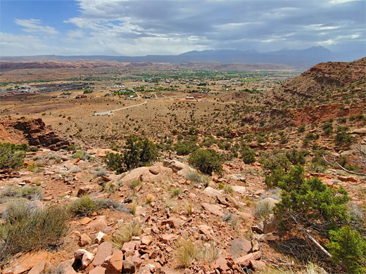
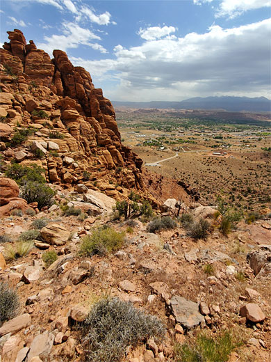
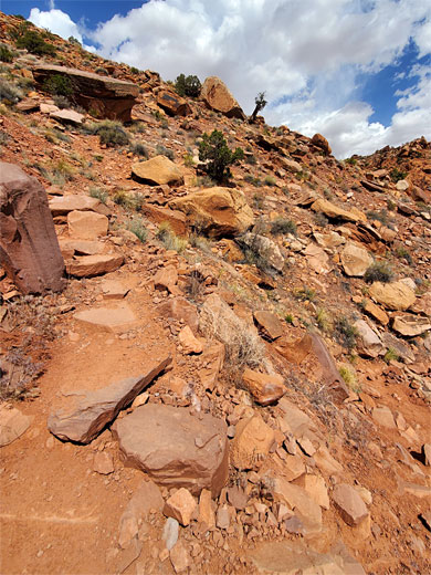
The hike itself is of three distinct sections, differing in length; the start is a relatively short but steep scramble up talus ledges and boulders, plus a small outcrop of the Chinle Formation - rising 500 feet over half a mile, all the while offering ever better views of Spanish Valley below and the La Sal Mountains off to the southeast.
The middle section of the hike, the longest (1.5 miles) is all along the flat valley floor, which is dry, covered mostly by grasses and wildflowers, with scattered juniper trees along the edges. In the final section, 0.5 miles, the trail reaches a saddle, exits the north end of the valley and descends, following a minor drainage through a more generally rocky area, ending at an intersection with a 4WD track, the Moab Rim Trail, which leads ultimately to Kane Springs Road by the Colorado River.
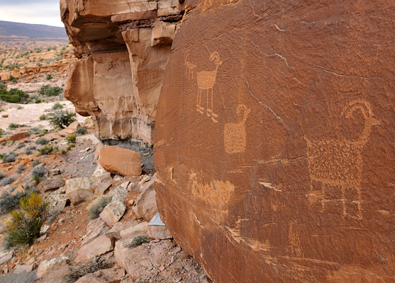
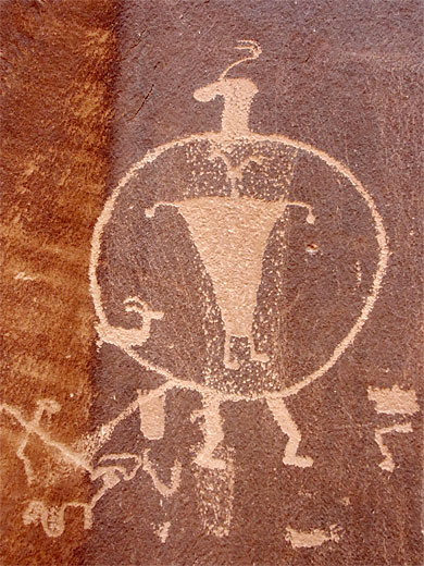
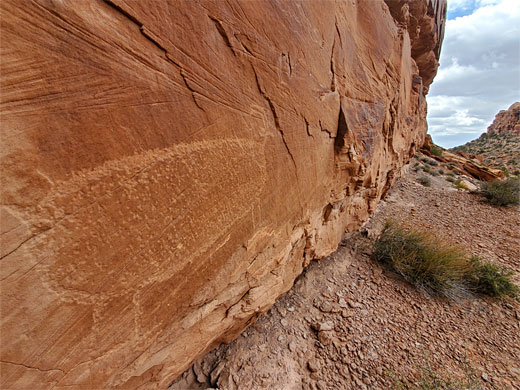
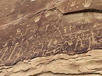
Just before the end of the hiking trail, a short distance north, is a line of Kayenta cliffs adorned with hundreds of petroglyphs, some large and well preserved; one of the highlights of the hike, along with the varied scenery en route and the long distance views, particularly at the start and the end.
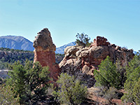
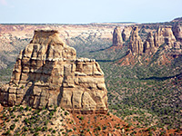
29 views along the Hidden Valley Trail.
Petroglyphs at the end of the trail.
The Hidden Valley trailhead, not signed from the highway, is reached by driving two blocks uphill on Angel Rock Road then one block northwest on Rim Rock Lane and finally a little way along a gravel track, to the parking place. One other path starts here (Pipe Dream Trail) heading northwest along the base of the cliffs, but most people are here for the valley, the path to which starts off by climbing a talus slope to the south, crossing a few little ravines whilst curving to the west, rising through many short switchbacks, up steep, boulder-strewn slopes which are hot and exposed in morning and early afternoon, if the sun is shining.
Eventually the path passes the last boulder piles, crests the valley rim and enters quite a different landscape, of flat grassland, a sandy floor, and slopes on either side, much higher to the west. The path follows the valley northwards, over a little ridge with a few exposed rocks, about halfway along, followed by grassland again, to the more jumbled terrain at the north end of the valley, where the route veers left and starts to descend, alongside a minor drainage, onto the junction with the Moab Rim Trail. Near here, a faint unsigned path on the right forms a loop, running partially at the base of a line of cliffs to the north, location of the rock art, most of which is part of a near-continuous band of about a quarter of a mile, all along the lower portion of the cliff, just above an inclined bench, sloping gently up to the southeast. In other direction, round a corner, is a little side valley which also has a few petroglyphs, on the cliffs on the far side. In general, the petroglyphs are many and varied; bighorn sheep feature prominently, plus elk, human figures and geometric shapes. Other evidence of the ancient peoples includes two stone circles atop the cliffs to the north of the side valley, reachable by climbing up from below.
The valley is lined to the east by relatively low cliffs of the Kayenta Formation, and on the other side by a short band of the Kayenta beneath a much taller exposure of Navajo sandstone, and when viewed from the highway below is essentially hidden, only properly appearing once having climbed up the lower slopes and entering the southern end.
The hike itself is of three distinct sections, differing in length; the start is a relatively short but steep scramble up talus ledges and boulders, plus a small outcrop of the Chinle Formation - rising 500 feet over half a mile, all the while offering ever better views of Spanish Valley below and the La Sal Mountains off to the southeast.
The middle section of the hike, the longest (1.5 miles) is all along the flat valley floor, which is dry, covered mostly by grasses and wildflowers, with scattered juniper trees along the edges. In the final section, 0.5 miles, the trail reaches a saddle, exits the north end of the valley and descends, following a minor drainage through a more generally rocky area, ending at an intersection with a 4WD track, the Moab Rim Trail, which leads ultimately to Kane Springs Road by the Colorado River.
Just before the end of the hiking trail, a short distance north, is a line of Kayenta cliffs adorned with hundreds of petroglyphs, some large and well preserved; one of the highlights of the hike, along with the varied scenery en route and the long distance views, particularly at the start and the end.
Photographs
29 views along the Hidden Valley Trail.
Hidden Valley Video
Petroglyphs at the end of the trail.
Hidden Valley Trailhead
The Hidden Valley trailhead, not signed from the highway, is reached by driving two blocks uphill on Angel Rock Road then one block northwest on Rim Rock Lane and finally a little way along a gravel track, to the parking place. One other path starts here (Pipe Dream Trail) heading northwest along the base of the cliffs, but most people are here for the valley, the path to which starts off by climbing a talus slope to the south, crossing a few little ravines whilst curving to the west, rising through many short switchbacks, up steep, boulder-strewn slopes which are hot and exposed in morning and early afternoon, if the sun is shining.
The Canyon
Eventually the path passes the last boulder piles, crests the valley rim and enters quite a different landscape, of flat grassland, a sandy floor, and slopes on either side, much higher to the west. The path follows the valley northwards, over a little ridge with a few exposed rocks, about halfway along, followed by grassland again, to the more jumbled terrain at the north end of the valley, where the route veers left and starts to descend, alongside a minor drainage, onto the junction with the Moab Rim Trail. Near here, a faint unsigned path on the right forms a loop, running partially at the base of a line of cliffs to the north, location of the rock art, most of which is part of a near-continuous band of about a quarter of a mile, all along the lower portion of the cliff, just above an inclined bench, sloping gently up to the southeast. In other direction, round a corner, is a little side valley which also has a few petroglyphs, on the cliffs on the far side. In general, the petroglyphs are many and varied; bighorn sheep feature prominently, plus elk, human figures and geometric shapes. Other evidence of the ancient peoples includes two stone circles atop the cliffs to the north of the side valley, reachable by climbing up from below.
Hidden Valley Wildflower
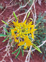 Yellow beeplant |
Topographic Map of the Hidden Valley Trail
Hidden Valley - Similar Hikes
All Contents © Copyright The American Southwest | Comments and Questions | Contribute | Affiliate Marketing Disclosure | Site Map