Natural Bridges National Monument - Hiking to the Bridges
Utah > Natural Bridges National Monument > Hiking
Natural Bridges Trails
Three short trails that descend to the base of the natural bridges, all located in quite a deep and narrow canyon. The Sipapu path continues another mile to Horse Collar Ruin
Length: 0.6 miles (Sipapu), 0.7 miles (Kachina), 0.2 miles (Owachomo)
Elevation change: 500 feet, 400 feet, 90 feet
Difficulty: Moderate, easy, easy
Type: All are one way trails, though the three bridges can also be seen via an 8 mile loop path
Usage: High
Season: All year. Ice may make some sections hazardous in winter
Trailhead: Pullouts along the loop road; Sipapu, Kachina, Owachomo
Rating (1-5): ★★★★★

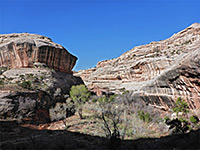
Sipapu, Kachina and Owachomo can all be seen from the loop drive in Natural Bridges National Monument, but far better views are available by walking the short trails that descend the canyon walls and lead right underneath each bridge. An 8 mile path links the three bridges, partly along the canyon floor and partly over the plateau, though most hikers just visit each bridge separately.
Map of Natural Bridges National Monument.
20 views of Natural Bridges National Monument.
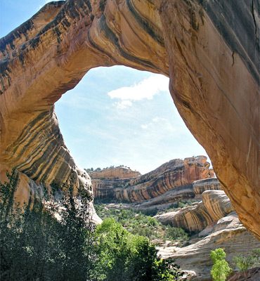
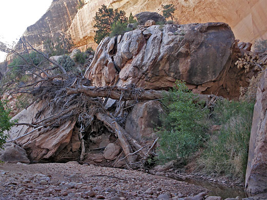
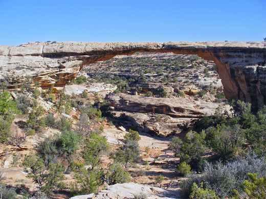
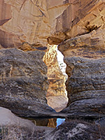
Sipapu is the biggest bridge in terms of height and span, and the most impressive when viewed from below. The trailhead is located a little way beyond the main roadside viewpoint, from where the path descends steeply to the canyon floor; the half mile journey is somewhat strenuous, and has some parts where ladders are installed to traverse vertical cliffs, yet the trail is popular since the bridge is the first along the park road, and arguably the best. The path drops over the plateau edge and soon passes a small Anasazi ruin in a cliff alcove, then after another descent, follows a flat layer for a while, out to a good viewpoint of White Canyon. Next is a crossing of a bushy hillside, a descent of a slickrock slope and finally a climb down a wooden ladder into a small grove of Gambel's oak trees beneath the bridge - part of a cool, green environment quite sheltered from the sun, and kept moist by the seasonal stream that flows through the canyon. The buff colored sandstone of the bridge bears a fine coating of desert varnish, making a nice contrast with the dark green trees growing beneath.
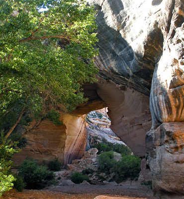
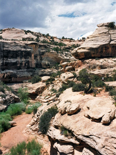
The longer path down White Canyon heads off downstream from Sipapu Bridge, with the next arch (Kachina) about 3 miles away, but the interesting Anasazi dwellings of Horse Collar Ruin are reached after less than one mile. The trail is well marked, winding either through overgrown sand banks at the side of the ravine or across pebbly ground by the streambed, past the junction with a large tributary drainage on the north side (Deer Canyon, which contains pools and narrows) and on to the base of the ruins. Although there is no obvious path to the buildings, located quite high up on the north side of the canyon, they can be visited by scrambling up the steep slickrock beneath. The dwellings are well protected from sun and rain by the overhanging cliffs above, and they still have several rooms intact (two granaries and a kiva), some with unusual horseshoe-shaped openings in the walls. The ruins can be observed from afar by a 0.3 mile trail over the mesa top, starting along the loop drive.
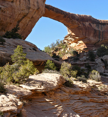
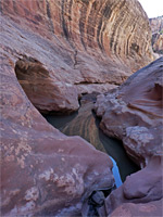
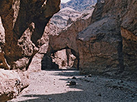
The most geologically recent of the three natural bridges is Kachina, characterized by a relatively small opening beneath a very thick span, making the arch difficult to spot from the highway. The path to the bridge is the longest of the three so not as many people make the hike, despite it being quite easy. The trail begins next to Kachina overlook; it descends a little, rounds a promontory beneath the viewpoint then drops down a lot more via many stone steps, to a junction with the canyon trail, here running a little way above the streambed in order to avoid a big pour-off just upstream. Turning right, the path soon reaches the wash, via a short ladder at one point, then follows alongside the stream to the bridge, which spans White Canyon just as it joins Armstrong Canyon and is enclosed on most sides by vertical cliffs, rising rather higher then the bridge itself. The thickness of the bridge and the steepness of the surrounding rocks make the large area underneath particularly cool and shady, though this also makes photography rather difficult, especially as the arch is in shadow most of the day, and further obscured by tall cottonwood trees that grow at either side. This is a quiet, peaceful place most of the time but subject to occasional stormy conditions as shown both from the large mass of sandstone boulders on the north side, remains of 4,000 tons of rock that fell from the bridge in 1992, and the deep pools and big piles of driftwood along the streambed - results of the powerful flash floods that often tear through the canyon, especially during the summer thunderstorm season.
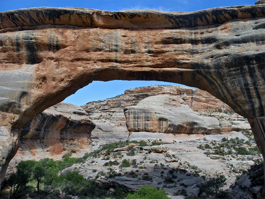
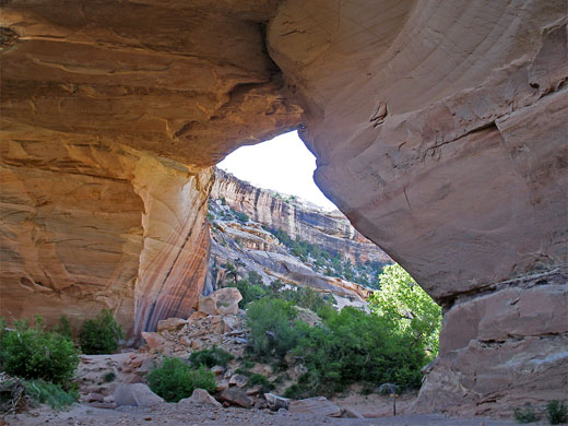
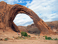
Owachomo may be viewed by a quick hike along an easy trail down a fairly gentle slope starting at the roadside viewpoint, ending at a slickrock bowl directly beneath, at the edge of Armstrong Canyon which runs past on the north side. Armstrong is rather shallow at this point but still receives big floods periodically as evident from a huge, permanent pool just downstream. The bridge spans 180 feet but is just 9 feet thick so will be the first of the three to break, yet it is still likely to survive for several more centuries. Continuation hikes are possible either down the canyon via the 8 mile trail, up the cliffs on the far side to an alternative viewpoint of the bridge, or upstream - although this part of Armstrong Canyon has no path, the terrain is quite moderate, and similarly for the nearby tributary of Tuwa Canyon.
Location
Map of Natural Bridges National Monument.
Photographs
20 views of Natural Bridges National Monument.
Sipapu Bridge - 0.6 miles, 500 foot descent
Sipapu is the biggest bridge in terms of height and span, and the most impressive when viewed from below. The trailhead is located a little way beyond the main roadside viewpoint, from where the path descends steeply to the canyon floor; the half mile journey is somewhat strenuous, and has some parts where ladders are installed to traverse vertical cliffs, yet the trail is popular since the bridge is the first along the park road, and arguably the best. The path drops over the plateau edge and soon passes a small Anasazi ruin in a cliff alcove, then after another descent, follows a flat layer for a while, out to a good viewpoint of White Canyon. Next is a crossing of a bushy hillside, a descent of a slickrock slope and finally a climb down a wooden ladder into a small grove of Gambel's oak trees beneath the bridge - part of a cool, green environment quite sheltered from the sun, and kept moist by the seasonal stream that flows through the canyon. The buff colored sandstone of the bridge bears a fine coating of desert varnish, making a nice contrast with the dark green trees growing beneath.
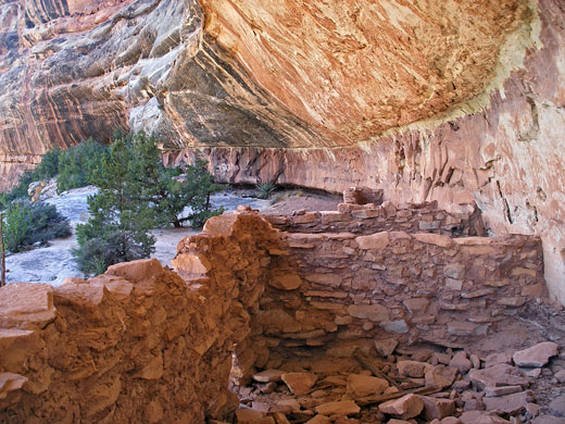
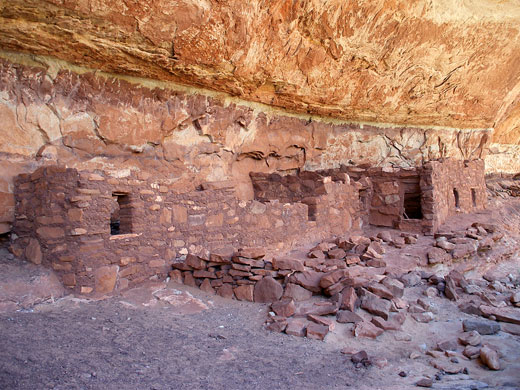
Horse Collar Ruin
The longer path down White Canyon heads off downstream from Sipapu Bridge, with the next arch (Kachina) about 3 miles away, but the interesting Anasazi dwellings of Horse Collar Ruin are reached after less than one mile. The trail is well marked, winding either through overgrown sand banks at the side of the ravine or across pebbly ground by the streambed, past the junction with a large tributary drainage on the north side (Deer Canyon, which contains pools and narrows) and on to the base of the ruins. Although there is no obvious path to the buildings, located quite high up on the north side of the canyon, they can be visited by scrambling up the steep slickrock beneath. The dwellings are well protected from sun and rain by the overhanging cliffs above, and they still have several rooms intact (two granaries and a kiva), some with unusual horseshoe-shaped openings in the walls. The ruins can be observed from afar by a 0.3 mile trail over the mesa top, starting along the loop drive.
Kachina Bridge - 0.7 miles, 400 foot descent
The most geologically recent of the three natural bridges is Kachina, characterized by a relatively small opening beneath a very thick span, making the arch difficult to spot from the highway. The path to the bridge is the longest of the three so not as many people make the hike, despite it being quite easy. The trail begins next to Kachina overlook; it descends a little, rounds a promontory beneath the viewpoint then drops down a lot more via many stone steps, to a junction with the canyon trail, here running a little way above the streambed in order to avoid a big pour-off just upstream. Turning right, the path soon reaches the wash, via a short ladder at one point, then follows alongside the stream to the bridge, which spans White Canyon just as it joins Armstrong Canyon and is enclosed on most sides by vertical cliffs, rising rather higher then the bridge itself. The thickness of the bridge and the steepness of the surrounding rocks make the large area underneath particularly cool and shady, though this also makes photography rather difficult, especially as the arch is in shadow most of the day, and further obscured by tall cottonwood trees that grow at either side. This is a quiet, peaceful place most of the time but subject to occasional stormy conditions as shown both from the large mass of sandstone boulders on the north side, remains of 4,000 tons of rock that fell from the bridge in 1992, and the deep pools and big piles of driftwood along the streambed - results of the powerful flash floods that often tear through the canyon, especially during the summer thunderstorm season.
Owachomo Bridge - 0.2 miles, 90 foot descent
Owachomo may be viewed by a quick hike along an easy trail down a fairly gentle slope starting at the roadside viewpoint, ending at a slickrock bowl directly beneath, at the edge of Armstrong Canyon which runs past on the north side. Armstrong is rather shallow at this point but still receives big floods periodically as evident from a huge, permanent pool just downstream. The bridge spans 180 feet but is just 9 feet thick so will be the first of the three to break, yet it is still likely to survive for several more centuries. Continuation hikes are possible either down the canyon via the 8 mile trail, up the cliffs on the far side to an alternative viewpoint of the bridge, or upstream - although this part of Armstrong Canyon has no path, the terrain is quite moderate, and similarly for the nearby tributary of Tuwa Canyon.
Natural Bridges - Similar Hikes
All Contents © Copyright The American Southwest | Comments and Questions | Contribute | Affiliate Marketing Disclosure | Site Map