Trachyte Creek
Long, branched drainage holding a permanent stream; a section of the upper canyon has an enclosed section with waterfalls, while a north fork forms shallow narrows through nicely colored rocks
Length: 6 miles, round trip; down the north fork and up the main canyon
Difficulty: Easy
Management: BLM
Rocks: Navajo sandstone
Season: Spring, summer, fall
Trailhead: Start of a side track, along UT 276 just north of the bridge over the creek
Rating (1-5): ★★★★★
Difficulty: Easy
Management: BLM
Rocks: Navajo sandstone
Season: Spring, summer, fall
Trailhead: Start of a side track, along UT 276 just north of the bridge over the creek
Rating (1-5): ★★★★★

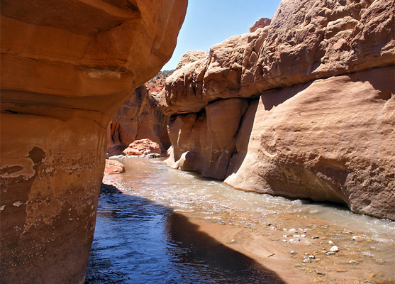
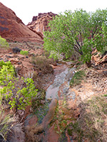
Although only ten miles long, Trachyte Creek has around 20 significant tributary canyons, all quite deeply incised into a big area of exposed Navajo sandstone extending south from Trachyte Point. The main gorge is mostly quite wide, containing a permanent stream flowing past sandbanks bearing trees and bushes, but its upper part has a few quite pretty sections where the waters form cascades, waterfalls and curving channels, as the canyon becomes temporarily vertical walled and moderately narrow.
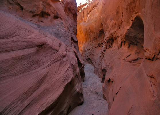
A parallel tributary - the north fork - is rather more confined and has several proper slot sections, which while never very deep, are colorful and easy to explore. A round trip down the dry slot and back up the watery main fork makes a pleasant half day hike, encountering a good variety of rock forms and desert scenery.
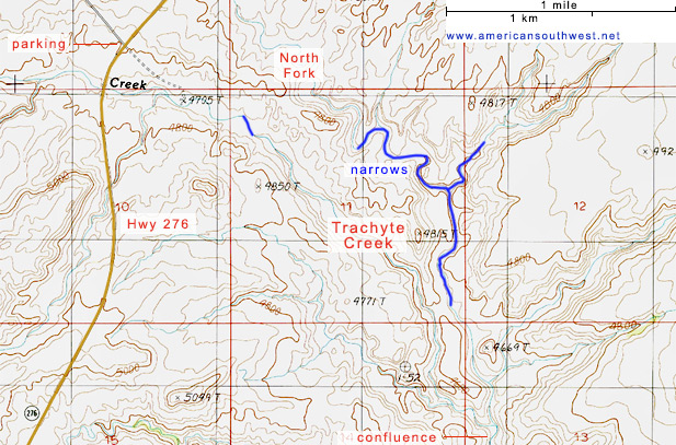
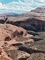
The upper end of Trachyte Creek crosses UT 276 near milepost 5, just south of the junction with an unpaved track that leads westwards towards ranches, old mines, and other interesting sites in the nearby Henry Mountains. The north fork of the creek meets the main road one mile away. Parking is a little restricted along this part of the highway so the best place to leave vehicles is at the road junction. Places for camping are also limited; although all the surroundings are BLM land, there are few other side tracks along the main road, and sites further north around the UT 95 intersection are quite often taken by people exploring the North Wash canyons. One good location close to Trachyte Creek is on top of a small hill a little way along the side road, reached by a short, disused track that forks right after 0.3 miles. The site is quite exposed, and is visible (at a distance) from the highway, but it has fine, elevated, 360° views of the desert surroundings, including the high peaks of the Henry Mountains and the vast slickrock and canyon landscape around lower Trachyte Creek.
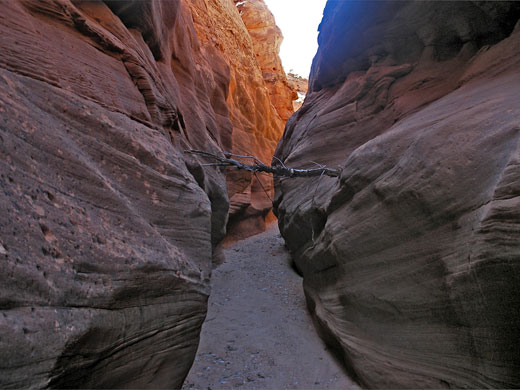
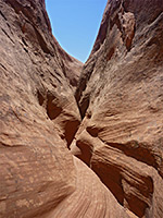
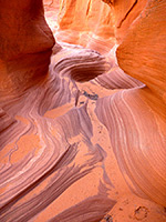
Either side of the highway, the north fork of Trachyte Creek is a dry, sandy wash. Walking downstream, the drainage rounds a few small bends then drops 40 feet over a dryfall, an obstruction easily passed on the right. A semi-permanent pool lies beneath, surrounded by cool, mossy walls. Beyond this the streambed stays relatively wide for a while before entering the first of three colorful, narrow passageways of increasing depth - each fairly short and never particularly enclosed, but pretty, bordered by smooth orange/red rock displaying thin strata and water-carved undulations. The last and deepest contains several logs wedged across the streamway, and a huge boulder in the middle, partly blocking the passage and causing further driftwood to accumulate. There are no obstacles in the narrows, and plenty of climb out routes. A tributary joins from the north; upstream are more shallow slots interrupted by chokestones, and drops of a few feet over dryfalls.
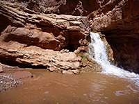
The surroundings change from small, soil-covered hills and low cliffs of crumbling strata, to rounded Navajo sandstone domes, as the dry streamway turns due south and widens to a bright, sandy-floored wash beneath reddish, vertical walls, and soon meets the main fork of Trachyte Creek with its year round flow. This canyon provides easy walking upstream beside the water, crossing the creek several times to avoid deeper sections on one side or the other. The water is mostly shallow but fast moving, flowing over a few minor falls and cascades between longer, more level stretches. Some places have deeper, narrower channels through patches of exposed rock. The walls are vertical in only a few places, where the canyon becomes quite confined; mostly they are gently sloping, the wash open and sunny. In one spot the waters flow swiftly along a shallow, curving channel then fall 20 feet into a narrow gorge with pools and boulders; quite a photogenic scene. Highway 276 approaches soon after the falls, and the return route is along a disused track, past some concrete foundations suggesting that a house once stood here. All this area seems little visited, though faint tire marks on the track and in the canyon indicate that ATVs sometimes drive right down the creek and up the north fork tributary to the end of the slot.
A parallel tributary - the north fork - is rather more confined and has several proper slot sections, which while never very deep, are colorful and easy to explore. A round trip down the dry slot and back up the watery main fork makes a pleasant half day hike, encountering a good variety of rock forms and desert scenery.
Topographic Map of Trachyte Creek
Location
The upper end of Trachyte Creek crosses UT 276 near milepost 5, just south of the junction with an unpaved track that leads westwards towards ranches, old mines, and other interesting sites in the nearby Henry Mountains. The north fork of the creek meets the main road one mile away. Parking is a little restricted along this part of the highway so the best place to leave vehicles is at the road junction. Places for camping are also limited; although all the surroundings are BLM land, there are few other side tracks along the main road, and sites further north around the UT 95 intersection are quite often taken by people exploring the North Wash canyons. One good location close to Trachyte Creek is on top of a small hill a little way along the side road, reached by a short, disused track that forks right after 0.3 miles. The site is quite exposed, and is visible (at a distance) from the highway, but it has fine, elevated, 360° views of the desert surroundings, including the high peaks of the Henry Mountains and the vast slickrock and canyon landscape around lower Trachyte Creek.

North Fork of Trachyte Creek
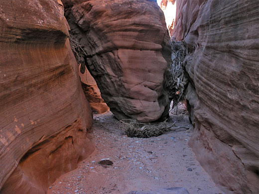
Either side of the highway, the north fork of Trachyte Creek is a dry, sandy wash. Walking downstream, the drainage rounds a few small bends then drops 40 feet over a dryfall, an obstruction easily passed on the right. A semi-permanent pool lies beneath, surrounded by cool, mossy walls. Beyond this the streambed stays relatively wide for a while before entering the first of three colorful, narrow passageways of increasing depth - each fairly short and never particularly enclosed, but pretty, bordered by smooth orange/red rock displaying thin strata and water-carved undulations. The last and deepest contains several logs wedged across the streamway, and a huge boulder in the middle, partly blocking the passage and causing further driftwood to accumulate. There are no obstacles in the narrows, and plenty of climb out routes. A tributary joins from the north; upstream are more shallow slots interrupted by chokestones, and drops of a few feet over dryfalls.
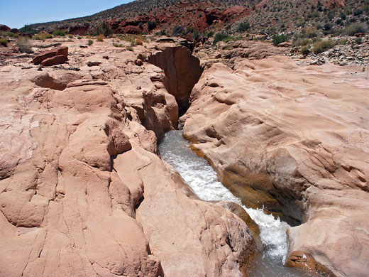
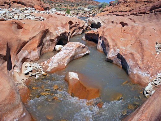
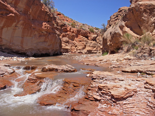
Main Branch of Trachyte Creek
The surroundings change from small, soil-covered hills and low cliffs of crumbling strata, to rounded Navajo sandstone domes, as the dry streamway turns due south and widens to a bright, sandy-floored wash beneath reddish, vertical walls, and soon meets the main fork of Trachyte Creek with its year round flow. This canyon provides easy walking upstream beside the water, crossing the creek several times to avoid deeper sections on one side or the other. The water is mostly shallow but fast moving, flowing over a few minor falls and cascades between longer, more level stretches. Some places have deeper, narrower channels through patches of exposed rock. The walls are vertical in only a few places, where the canyon becomes quite confined; mostly they are gently sloping, the wash open and sunny. In one spot the waters flow swiftly along a shallow, curving channel then fall 20 feet into a narrow gorge with pools and boulders; quite a photogenic scene. Highway 276 approaches soon after the falls, and the return route is along a disused track, past some concrete foundations suggesting that a house once stood here. All this area seems little visited, though faint tire marks on the track and in the canyon indicate that ATVs sometimes drive right down the creek and up the north fork tributary to the end of the slot.
Nearby Slot Canyons
Bullfrog Bay Canyon
Butler Canyon
Cheesebox Canyon
Death Canyon
Fortknocker Canyon
Fry Canyon
Gravel Canyon
Hog Canyon
Long Canyon
Maidenwater Canyon
Maidenwater Canyon, North
North Trachyte Point Canyon
North Wash
Poison Spring Canyon
Rock Canyon
Smith Fork
Swett Creek
Trachyte Point Canyon
Trail Canyon
White Canyon
Butler Canyon
Cheesebox Canyon
Death Canyon
Fortknocker Canyon
Fry Canyon
Gravel Canyon
Hog Canyon
Long Canyon
Maidenwater Canyon
Maidenwater Canyon, North
North Trachyte Point Canyon
North Wash
Poison Spring Canyon
Rock Canyon
Smith Fork
Swett Creek
Trachyte Point Canyon
Trail Canyon
White Canyon
Trachyte Creek Canyon - Similar Hikes
All Contents © Copyright The American Southwest | Comments and Questions | Contribute | Affiliate Marketing Disclosure | Site Map