Upper West Fork
The west, or main fork of Water Holes Canyon itself splits into three branches, all of which have good, short, colorful narrows
Length: 6 miles; walk (or drive) from US 89
Trailhead: Parking area on the east side of US 89
Rating (1-5): ★★★★★
Trailhead: Parking area on the east side of US 89
Rating (1-5): ★★★★★

The west (main) fork of upper Water Holes Canyon splits into three branches, each of which has narrows, different in character - one forms a deep, sheer-walled gorge ending beneath a big dryfall, another is less deep but has a nice, short enclosed passageway through stripy white and brown sandstone, and the third becomes a tight slot - again rather short but very narrow, with patterns of light and erosion as good as any other canyon in the area.
This section of the drainage could perhaps be reached by walking westwards cross-country from Copper Mine Road, but more straightforward is to hike southeast from US 89, beside or along the streambed, which apart from the lower slot is wide and sandy all the way; to view the best parts of all three branches is a journey of about 12 miles, round trip. A Navajo access permit, required for all hiking on the reservation, may be obtained from the parks office at Leche-e, however as of May 2018 it seems that all the Water Holes area is off-limits to unaccompanied hikers, open only to the guided tour companies, even though they do not travel to the west fork tributaries.
Topographic map of Water Holes Canyon.
23 views of the west fork of upper Water Holes Canyon.
One possible parking place for the hike to the upper west fork of Water Holes is next to the US 89 bridge over the canyon, from where the best route is over the sand dunes and slickrock bordering the north side of the lower narrows (an area with some nice erosional features, including an oft-photographed wave-like terrace known as the Great Wall), before meeting a dirt track after one mile, then descending into the canyon as it widens to a sandy wash. Another potential parking spot is also on US 89, 0.7 miles south, beside the start of a track that heads east, past a Navajo residence, and descends into the same drainage after a mile. The sandy wash is then followed further upstream, to the first major junction; left is the middle fork, while right is the west fork. Between the two forks is a 4WD track leading up a steep sandy hillside, part of the route used by the tour companies to reach Secret Canyon, bypassing a short slot just upstream on the middle fork. The west fork becomes quite wide, and is straight for nearly a mile, before another junction, soon after which the east branch splits again. Each of the three branches has narrows, as described below.
See the narrows on a Navajo guided tour - the only way to visit the canyon.
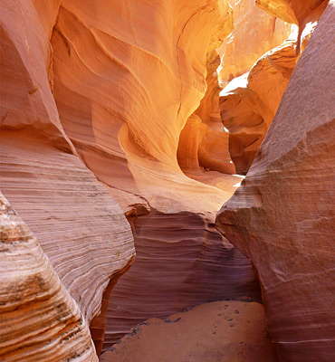
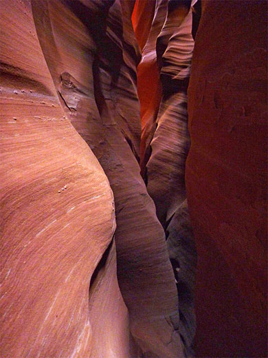
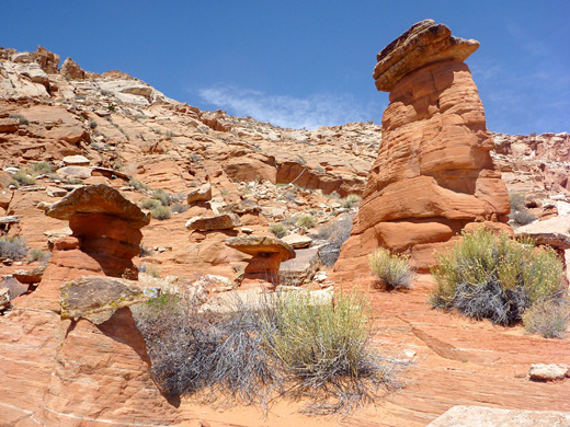
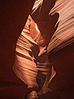
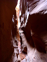
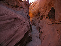
The westernmost drainage runs beneath the edge of a low mesa, passing some eroded rock formations that are quite varied in color and shape, and include a few reddish hoodoos. The streambed changes from sand to rock, and the wash narrows to form a slot, preceded by a curvy passage through especially colorful, stripy sandstone. After a short enclosed section, the wash briefly widens, then closes in abruptly, becoming quite deep and just one foot wide in places so the canyon is rather gloomy at floor level, but has nice light effects higher up, where the sandstone is bathed in dark shades of red and orange. The slot twists and turns, gaining height via a few small dryfalls and one taller drop of about 15 feet that is not so easy to climb, but instead, the upper passageways can be seen by retreating to the start of the narrows, ascending the cliffs on the east side, then re-entering higher up the drainage - here are shallower passages, containing potholes and a few chokestones.
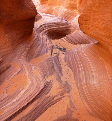
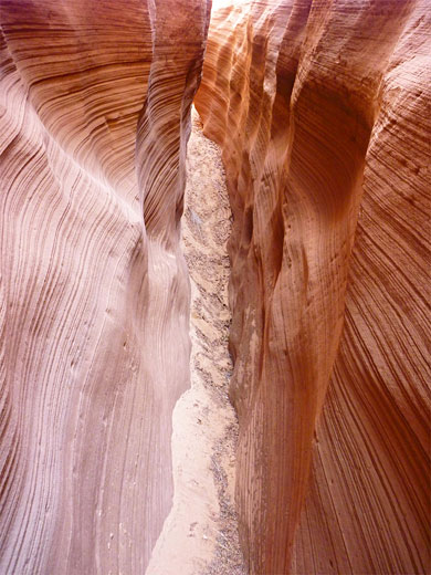
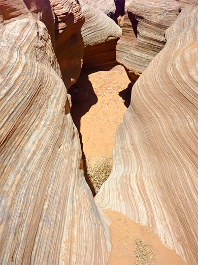
The middle branch is a longer drainage but this stays wide except for a brief, entrenched, photogenic section through whitish sandstone containing numerous thin, greyish strata, topped by straight cliffs of dark brown rock. Beyond a few bends, the canyon opens out again to another wide wash between sloping sides, eventually ending beneath a tall dryfall.
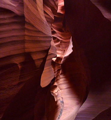
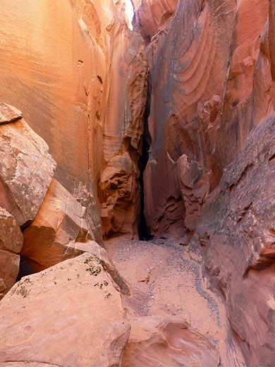
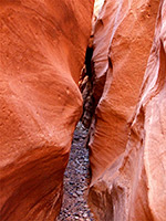
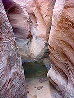
The east branch is the main drainage of the whole Water Holes system, and narrows after a while to a vertical-walled gorge which is about 30 feet across at floor level apart from a couple of very short slots, one of which holds a pool up to 6 feet deep after rainfall. The canyon ends at an enclosed chamber beneath a sheer, 150 foot dryfall.
This section of the drainage could perhaps be reached by walking westwards cross-country from Copper Mine Road, but more straightforward is to hike southeast from US 89, beside or along the streambed, which apart from the lower slot is wide and sandy all the way; to view the best parts of all three branches is a journey of about 12 miles, round trip. A Navajo access permit, required for all hiking on the reservation, may be obtained from the parks office at Leche-e, however as of May 2018 it seems that all the Water Holes area is off-limits to unaccompanied hikers, open only to the guided tour companies, even though they do not travel to the west fork tributaries.
Map
Topographic map of Water Holes Canyon.
Photographs
23 views of the west fork of upper Water Holes Canyon.
Route Description
One possible parking place for the hike to the upper west fork of Water Holes is next to the US 89 bridge over the canyon, from where the best route is over the sand dunes and slickrock bordering the north side of the lower narrows (an area with some nice erosional features, including an oft-photographed wave-like terrace known as the Great Wall), before meeting a dirt track after one mile, then descending into the canyon as it widens to a sandy wash. Another potential parking spot is also on US 89, 0.7 miles south, beside the start of a track that heads east, past a Navajo residence, and descends into the same drainage after a mile. The sandy wash is then followed further upstream, to the first major junction; left is the middle fork, while right is the west fork. Between the two forks is a 4WD track leading up a steep sandy hillside, part of the route used by the tour companies to reach Secret Canyon, bypassing a short slot just upstream on the middle fork. The west fork becomes quite wide, and is straight for nearly a mile, before another junction, soon after which the east branch splits again. Each of the three branches has narrows, as described below.
Tours of Secret Canyon
See the narrows on a Navajo guided tour - the only way to visit the canyon.
West Branch of the West Fork
The westernmost drainage runs beneath the edge of a low mesa, passing some eroded rock formations that are quite varied in color and shape, and include a few reddish hoodoos. The streambed changes from sand to rock, and the wash narrows to form a slot, preceded by a curvy passage through especially colorful, stripy sandstone. After a short enclosed section, the wash briefly widens, then closes in abruptly, becoming quite deep and just one foot wide in places so the canyon is rather gloomy at floor level, but has nice light effects higher up, where the sandstone is bathed in dark shades of red and orange. The slot twists and turns, gaining height via a few small dryfalls and one taller drop of about 15 feet that is not so easy to climb, but instead, the upper passageways can be seen by retreating to the start of the narrows, ascending the cliffs on the east side, then re-entering higher up the drainage - here are shallower passages, containing potholes and a few chokestones.
Middle Branch of the West Fork
The middle branch is a longer drainage but this stays wide except for a brief, entrenched, photogenic section through whitish sandstone containing numerous thin, greyish strata, topped by straight cliffs of dark brown rock. Beyond a few bends, the canyon opens out again to another wide wash between sloping sides, eventually ending beneath a tall dryfall.
East Branch of the West Fork
The east branch is the main drainage of the whole Water Holes system, and narrows after a while to a vertical-walled gorge which is about 30 feet across at floor level apart from a couple of very short slots, one of which holds a pool up to 6 feet deep after rainfall. The canyon ends at an enclosed chamber beneath a sheer, 150 foot dryfall.
West Fork of Water Holes Canyon - Similar Hikes
All Contents © Copyright The American Southwest | Comments and Questions | Contribute | Affiliate Marketing Disclosure | Site Map