Slot canyons near Page and the west end of Lake Powell, Utah/Arizona.
Antelope Canyon Tours
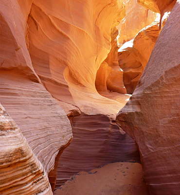
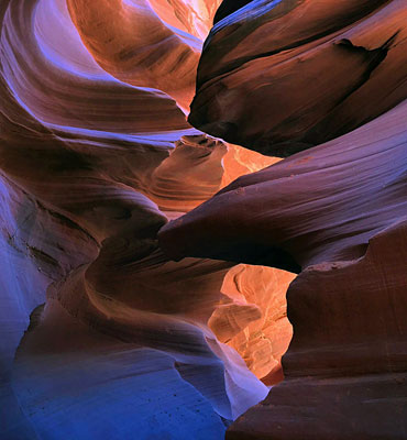
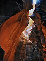
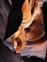
Antelope Canyon
★★★★★
★★★★★
0.1 miles, 0 feet
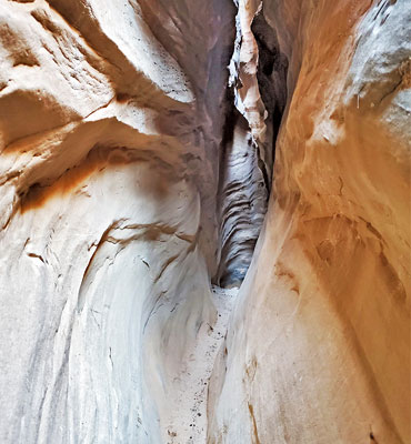
Beautiful but commercialized slot canyon, visited by hundreds of people on a typical day in summer. Two sections are open to visitors; the 600 foot long upper narrows, south of AZ 98, and the deeper lower narrows to the northBlue Pool Wash
★★★★★
★★★★★
1.2 miles, 80 feet
Minor drainage with a short narrows section through light colored Entrada sandstone, interrupted by several chokestones and dryfalls, at least one of which is not free climbableButterfly Canyon
★★★★★
★★★★★
3.5 miles, 800 feet
Shallow, quite pretty narrows followed by a much deeper and darker slot canyon, blocked at intervals by dryfalls, that eventually meets Lake Powell. Currently closed to all hikersPotato Canyon
★★★★★
★★★★★
9 miles, round trip
Deep, branched slots through richly-colored sandstone, mostly inaccessible unless rappelling. The upper end of a long tributary of Navajo CreekStarting Water Wash
★★★★★
★★★★★
2.5 miles, 400 feet
Long slot canyon tributary of Kaibito Creek; extended narrows becoming totally dark in places. One of the best canyons on the Colorado Plateau, but currently closed to all hikersStateline Canyon
★★★★★
★★★★★
2 miles, 300 feet
Short, shallow but quite photogenic and easily explored slot canyon, reached by a short walk from US 89, and ending at Lake Powell.Upper Kaibito Creek
★★★★★
★★★★★
0.8 miles, 200 feet
Deep, exciting, challenging canyon, one requiring rappelling in many places. A short section of the uppermost narrows is accessible to hikers, but all the canyon is currently closed by the NavajoUpper Kaibito Creek, East Fork
★★★★★
★★★★★
2 miles, 300 feet
Beautiful tributary of Kaibito Creek - many fins, small arches and interlinked potholes, all very colorful and nicely eroded. Currently closed to all hikersWahweap Canyon
★★★★★
★★★★★
1.4 miles, 120 feet
Short slot through greyish Entrada sandstone, 2 miles west of Wahweap Marina, spanning the Arizona-Utah stateline. Contains a tiny, spring-fed stream that sustains a population of orchidsWater Holes Canyon
★★★★★
★★★★★
1.6 miles, 400 feet
Branched drainage that forms several beautiful sections of slot canyon, separated by wide, sandy washes; short, pretty very narrow slots in the upper forks and a deeper, more extended gorge lower down. As of May 2018, all of the canyon may only be visited as part of a guided tourAntelope Canyon Tours
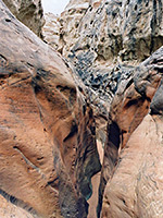
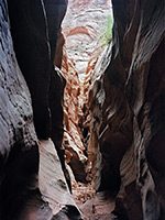
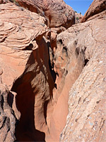
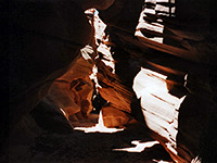
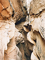
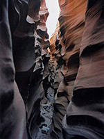
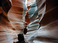
The canyons that cut through the soft Navajo sandstone rock south of the western end of Lake Powell near Page are the most beautiful and photogenic in the Southwest - they are typically very narrow but not too deep to prevent the sun from illuminating the passageways. The rocks have bright red to orange colors with pretty textures and patterns, and the movement of light and shadows during the day produces enchanting, ever-changing conditions.
All of this region is part of the Navajo Reservation, which issues permits for hiking and camping, though the requirement seems not to be widely enforced. Permits cost $5 for hiking, and may be obtained from the Navajo Tribal Parks Office beside the Leche-e Chapter House, 3 miles south of Page. However, Antelope Canyon, by far the most well-known slot in the area, may only be visited as part of an accompanied group and payment of an additional (large) fee. Guided tours are also available for several narrow parts of nearby Water Holes Canyon, which like Antelope is conveniently located adjacent to a main road (US 89).
All other slot canyons around Page are more difficult to reach, and require some degree of experience to locate and explore - the reservation is crossed by many dirt tracks which are unsignposted and sandy in places so detailed maps and a 4WD vehicle are advisable if exploring away from the main roads. There are many good canyons between Page and Navajo Mountain, 60 miles east, especially various tributaries of Navajo and Kaibito creeks, although these have been officially closed ever since 1998, with no access allowed, because of problems where the Navajo were forced to arrange expensive search and rescue operations to extricate unprepared hikers who became trapped in some of the deeper places. The major drainages with narrows are Butterfly Canyon, Chaol Canyon, Kaibito Creek, Peach Wash and Starting Water Wash, plus many unnamed branches of Navajo Creek, mostly on the north side.
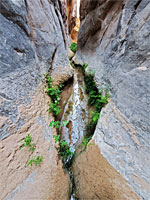
Canyons on the Navajo Reservation further east are currently open for exploration though they are very difficult to reach, and access by boat is probably easier. They include the remote West Canyon Creek, one of the most demanding narrows on the Southwest, which has many deep, long pools and sheer drops. On the west side of Page, the slot-forming Navajo sandstone is not exposed; the rocks along the western shore of Lake Powell are mostly Entrada sandstone, though a few short narrows are still found hereabouts such as Blue Pool Wash and Stateline Canyon.
All of this region is part of the Navajo Reservation, which issues permits for hiking and camping, though the requirement seems not to be widely enforced. Permits cost $5 for hiking, and may be obtained from the Navajo Tribal Parks Office beside the Leche-e Chapter House, 3 miles south of Page. However, Antelope Canyon, by far the most well-known slot in the area, may only be visited as part of an accompanied group and payment of an additional (large) fee. Guided tours are also available for several narrow parts of nearby Water Holes Canyon, which like Antelope is conveniently located adjacent to a main road (US 89).
Canyons on the Navajo Reservation further east are currently open for exploration though they are very difficult to reach, and access by boat is probably easier. They include the remote West Canyon Creek, one of the most demanding narrows on the Southwest, which has many deep, long pools and sheer drops. On the west side of Page, the slot-forming Navajo sandstone is not exposed; the rocks along the western shore of Lake Powell are mostly Entrada sandstone, though a few short narrows are still found hereabouts such as Blue Pool Wash and Stateline Canyon.
Related Sections
- Glen Canyon National Recreation Area - general information
- Page - the town and nearby facilities
All Contents © Copyright The American Southwest | Comments and Questions | Contribute | Affiliate Marketing Disclosure | Site Map