Highlights:
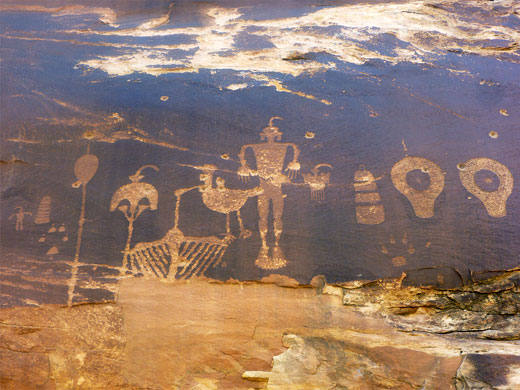
The best collections of ancient ruins, cliff dwellings and rock art sites in the Southwest, mostly dating from the Anasazi period of the 12th to 14th centuries. In general little hiking is needed, since most ruins are beside a road or at the end of a short trail
Type:
Loop, beginning at Phoenix. Albuquerque would be an alternative start point
Length:
1,325 miles, 2,130 km
Duration:
9 days minimum; 14 days or more with optional side trips
Seasons:
Spring and fall are preferred. Summers are rather hot, while some areas see snow and low temperatures in winter
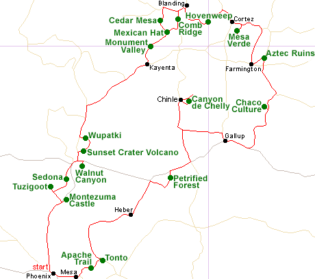
Map of the Indian lands Itinerary
Please refer to the disclosure notice for information about the affiliate (commissionable) links on this page.
Day 1 - Phoenix to Sedona, 140 miles
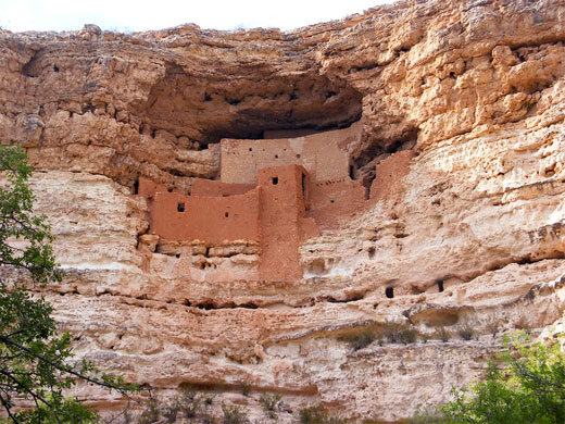
The tour begins by driving north along I-17 to the spectacular cliff dwelling of Montezuma Castle, followed by a visit to the hill-top ruins at Tuzigoot near Clarkdale. Scenic AZ 89A then leads to Sedona, Arizona's second most popular destination, at the entrance to Oak Creek Canyon.
Optional extra day: hiking in Sedona
Day 2 - Sedona to Kayenta, 190 miles
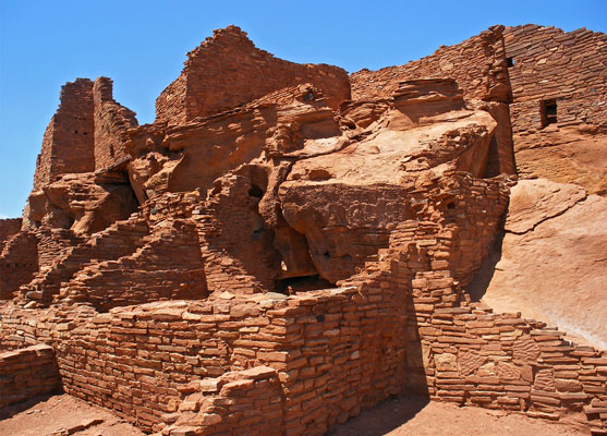
The next Indian site is just east of Flagstaff, 40 miles from Sedona, at Walnut Canyon, where many cliff dwellings can be seen via a short, steep trail. Also near Flagstaff, Wupatki National Monument features several photogenic, preserved, red rock ruins surrounded by flat, sandy desert; toured by a quiet backroad that also passes the volcanic landscapes of Sunset Crater. A two hour drive north and east on little-traveled roads through the heart of the Navajo Indian Reservation leads to Kayenta, along the southern approach to Monument Valley.
Optional extra day: South Rim of the Grand Canyon
Day 3 - Kayenta to Blanding, 120 miles
After a drive through the arcetypal Western scenery of Monument Valley, US 163 crosses into Utah and reaches the little village of Mexican Hat, at the foot of a high plateau (Cedar Mesa), where many ancient sites can be visited by long or short hikes; easiest reached are those along nearby Comb Ridge, though the best locations are on the mesa.
Optional extra day: more hiking in the Cedar Mesa region
Day 4 - Blanding to Cortez, 90 miles
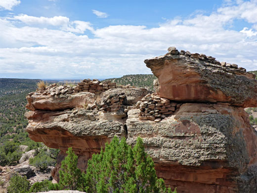
A short drive east of Bluff are two lesser known NPS sites (Hovenweep and Canyons of the Ancients), each containing many small ruins set in particularly remote, undeveloped country. The access road crosses into Colorado and soon reaches Cortez.
Day 5 - Cortez to Farmington, 120 miles
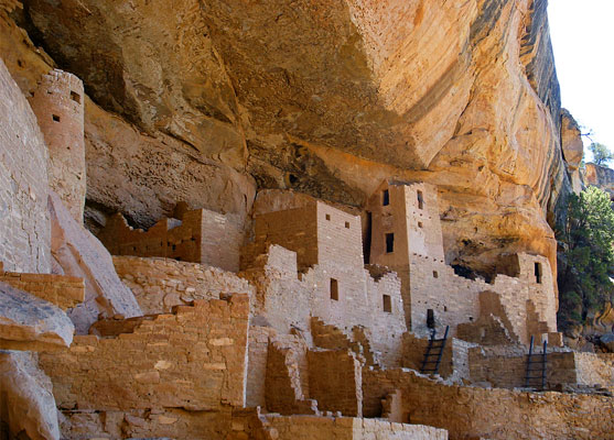
Cortez is the gateway to Mesa Verde National Park, which contains the largest and best preserved ruins in the Southwest. One full day spent here is enough to see all major overlooks and hike along a few trails. The main road south leads to Farmington in north New Mexico.
Day 6 - Farmington to Gallup, 185 miles
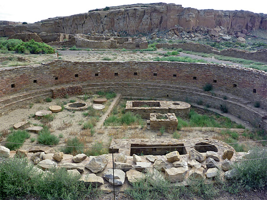
Aztec Ruins National Monument contains ruins of an extensive walled settlement from the 12th century, including a fully reconstructed kiva. Similar relics are seen at the remote Chaco Culture NHS to the south; rivalling Mesa Verde to be the most important and spectacular ancient site in the Southwest. Most of the ruins can be seen via roadside overlooks or short hikes. The nearby town of Gallup sits along old Route 66, and contains many reminders of the famous road.
Optional extra day: one or more of El Malpais National Monument (lava formations), El Morro National Monument (historic inscriptions, a pueblo ruin and colorful cliffs) and Bisti Wilderness (fantastic eroded rocks)
Day 7 - Gallup to Chinle, 130 miles
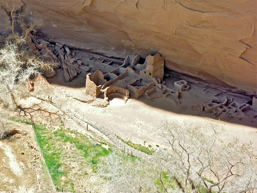
Deep, sheer-walled Canyon de Chelly in Arizona is 90 miles from Gallup; here many cliff-alcove ruins can be seen via overlooks; one (White House) by a mile long trail, and others by Navajo-led tours.
Day 8 - Chinle to Heber, 190 miles
US 191 provides a quick route back south, with a short detour through Petrified Forest National Park, site of amazingly colorful fossilized wood. A little way west, Holbrook is another small town along the course of Route 66, from where the road southwest crosses wide-open grasslands to the friendly town of Heber.
Day 9 - Heber to Mesa, 160 miles
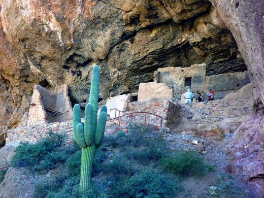
South of Heber, the road winds through pine forests for a while then descends steeply down the edge of a plateau (the Mogollon Rim), and soon returns to desert lands. Hwy 188 runs alongside Roosevelt Lake to the cliff dwellings of Tonto National Monument; the route back to Mesa and Phoenix is then via the very scenic (though partly unpaved) Apache Trail through the Superstition Mountains, passing several lakes and great expanses of cactus wilderness.
All Contents © Copyright The American Southwest | Comments and Questions | Contribute | Affiliate Marketing Disclosure | Site Map